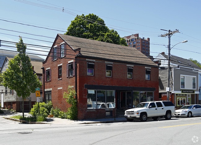
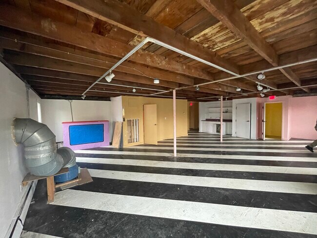
Property Record
34 Portland St, Yarmouth, ME 04096
NEARBY LISTINGS FOR SALE OR LEASE
Property Detail
34 Portland St
Sfr
Cumberland
X
Maine
23005C0541F
0.78 AC
2024
Bayside
2024
Portland/South Portland
000600
Portland-South Portland, ME
3,708 SF
YMTH-000032-000000-000013
DEMOGRAPHICS near 34 Portland St
1 Mile
3 Mile
5 Mile
2024 Total Population
25,858
76,076
114,197
2029 Population
26,953
78,387
117,927
Pop Growth 2024-2029
+ 4.23%
+ 3.04%
+ 3.27%
Average Age
38
41
42
2024 Total Households
13,897
36,313
52,437
HH Growth 2024-2029
+ 4.35%
+ 3.13%
+ 3.40%
Median Household Inc
$56,009
$69,719
$73,814
Avg Household Size
1.80
2.00
2.10
2024 Avg HH Vehicles
1.00
1.00
2.00
Median Home Value
$514,167
$427,978
$414,593
Median Year Built
1947
1949
1955
Nearby Places
Map Layers
Map Styles
 Street
 Aerial
- Restaurants
- Banks
- Shops
- Fitness
- Groceries
PUBLIC TRANSPORTATION
COMMUTER RAIL
Freeport Amtrak Station (Downeaster - Amtrak)
DRIVE
WALK
Distance
Freeport Amtrak Station (Downeaster - Amtrak)
10 min
6.1 mi
AIRPORT
Portland International Jetport
DRIVE
WALK
Distance
Portland International Jetport
22 min
14.4 mi
Freight Ports
Portland, ME
DRIVE
WALK
Distance
Portland, ME
16 min
11.4 mi
SALE & LEASE HISTORY
LISTING DATE
SALE/LEASE

Oct 31, 2022
For Sale
Oct 30, 2023
For Lease
Mar 30, 2021
For Sale
Apr 25, 2019
For Lease
Nearby Properties
Address
Land Use
TOTAL SIZE
Lot Size
Zoning
Address
Land Use
TOTAL SIZE
Lot Size
Zoning
152,724 SF
46.80 AC
13
Address
Land Use
TOTAL SIZE
Lot Size
Zoning
187,437 SF
62.85 AC
23
Address
Land Use
TOTAL SIZE
Lot Size
Zoning
Address
Land Use
TOTAL SIZE
Lot Size
Zoning
66.50 AC
RR2
Address
Land Use
TOTAL SIZE
Lot Size
Zoning
21.50 AC
13
Address
Land Use
TOTAL SIZE
Lot Size
Zoning
83,378 SF
42 AC
13
Address
Land Use
TOTAL SIZE
Lot Size
Zoning
93,752 SF
10.86 AC
21
Address
Land Use
TOTAL SIZE
Lot Size
Zoning
9.70 AC
CD4-C1
Address
Land Use
TOTAL SIZE
Lot Size
Zoning
7.42 AC
17
Address
Land Use
TOTAL SIZE
Lot Size
Zoning
60,698 SF
11.60 AC
CD4-C2
Address
Land Use
TOTAL SIZE
Lot Size
Zoning
47,488 SF
15.14 AC
CIVIC
Address
Land Use
TOTAL SIZE
Lot Size
Zoning
49,513 SF
4.06 AC
21
Address
Land Use
TOTAL SIZE
Lot Size
Zoning
37,746 SF
3.16 AC
LDR
Address
Land Use
TOTAL SIZE
Lot Size
Zoning
18 AC
13
Address
Land Use
TOTAL SIZE
Lot Size
Zoning
31,293 SF
7.20 AC
OC
Address
Land Use
TOTAL SIZE
Lot Size
Zoning
28,536 SF
7.10 AC
CD4-C1
Address
Land Use
TOTAL SIZE
Lot Size
Zoning
5.10 AC
24
Address
Land Use
TOTAL SIZE
Lot Size
Zoning
40.37 AC
13
Address
Land Use
TOTAL SIZE
Lot Size
Zoning
62,857 SF
23.10 AC
CM04
Address
Land Use
TOTAL SIZE
Lot Size
Zoning
153.50 AC
MDR/
Address
Land Use
TOTAL SIZE
Lot Size
Zoning
36,374 SF
5.80 AC
SD1
Address
Land Use
TOTAL SIZE
Lot Size
Zoning
2.10 AC
21
Address
Land Use
TOTAL SIZE
Lot Size
Zoning
23,362 SF
3.01 AC
13
Address
Land Use
TOTAL SIZE
Lot Size
Zoning
22,871 SF
3.43 AC
21
Address
Land Use
TOTAL SIZE
Lot Size
Zoning
100,815 SF
3 AC
22
Address
Land Use
TOTAL SIZE
Lot Size
Zoning
14.08 AC
12
Address
Land Use
TOTAL SIZE
Lot Size
Zoning
24,946 SF
2.77 AC
CD4-C2
Address
Land Use
TOTAL SIZE
Lot Size
Zoning
19,972 SF
1.46 AC
17
Address
Land Use
TOTAL SIZE
Lot Size
Zoning
12.07 AC
CM02
The World's #1 Commercial Real Estate Marketplace
Connect with us
© 2025 CoStar Group
The information above has been obtained from sources believed reliable. While we do not doubt its accuracy we have not verified it and make no guarantee, warranty or representation about it. It is your responsibility to independently confirm its accuracy and completeness. Any projections, opinions, assumptions, or estimates used are for example only and do not represent the current or future performance of the property. The value of this transaction to you depends on tax and other factors which should be evaluated by your tax, financial, and legal advisors. You and your advisors should conduct a careful, independent investigation of the property to determine to your satisfaction the suitability of the property for your needs.