Property Record
34 Sullivan Rd, North Billerica, MA 01862

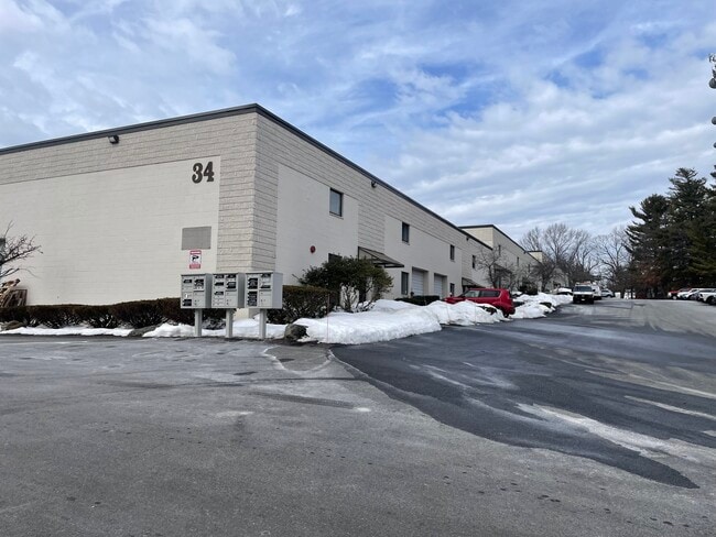
This Property Is For Sale
Current Lease Availabilities
NEARBY LISTINGS FOR SALE OR LEASE
Property Detail
34 Sullivan Rd
Publicschool
Middlesex
X
Massachusetts
25017C0254F
1-32
2024
Lowell/Chelmsford
2025
Boston
316400
Boston-Cambridge-Newton, MA-NH
2,715 SF
BILL-000037-000007-000001-000032
DEMOGRAPHICS near 34 Sullivan Rd
1 Mile
3 Mile
5 Mile
2024 Total Population
3,359
32,055
123,458
2029 Population
3,422
31,844
122,028
Pop Growth 2024-2029
+ 1.88%
(0.66%)
(1.16%)
Average Age
42
42
41
2024 Total Households
1,208
12,014
44,323
HH Growth 2024-2029
+ 1.99%
(0.75%)
(1.21%)
Median Household Inc
$132,386
$122,446
$106,664
Avg Household Size
2.60
2.60
2.70
2024 Avg HH Vehicles
2.00
2.00
2.00
Median Home Value
$542,531
$524,849
$485,787
Median Year Built
1995
1971
1967
Nearby Places
Map Layers
Map Styles
 Street
 Aerial
- Restaurants
- Banks
- Shops
- Fitness
- Groceries
PUBLIC TRANSPORTATION
COMMUTER RAIL
North Billerica (Lowell Line - Massachusetts Bay Transportation Authority Commuter Rail (Purple Line))
DRIVE
WALK
Distance
North Billerica (Lowell Line - Massachusetts Bay Transportation Authority Commuter Rail (Purple Line))
9 min
3.8 mi
Lowell (Lowell Line - Massachusetts Bay Transportation Authority Commuter Rail (Purple Line))
DRIVE
WALK
Distance
Lowell (Lowell Line - Massachusetts Bay Transportation Authority Commuter Rail (Purple Line))
14 min
6.9 mi
AIRPORT
General Edward Lawrence Logan International
DRIVE
WALK
Distance
General Edward Lawrence Logan International
46 min
29.6 mi
Manchester Boston Regional
DRIVE
WALK
Distance
Manchester Boston Regional
52 min
32.8 mi
Freight Ports
Port of Boston
DRIVE
WALK
Distance
Port of Boston
47 min
29.3 mi
Nearby Properties
Address
Land Use
TOTAL SIZE
Lot Size
Zoning
Address
Land Use
TOTAL SIZE
Lot Size
Zoning
225,792 SF
9.90 AC
4
Address
Land Use
TOTAL SIZE
Lot Size
Zoning
9.50 AC
Address
Land Use
TOTAL SIZE
Lot Size
Zoning
Address
Land Use
TOTAL SIZE
Lot Size
Zoning
27.48 AC
5
Address
Land Use
TOTAL SIZE
Lot Size
Zoning
504,154 SF
19.40 AC
2
Address
Land Use
TOTAL SIZE
Lot Size
Zoning
189,960 SF
7.88 AC
4
Address
Land Use
TOTAL SIZE
Lot Size
Zoning
6.36 AC
5
Address
Land Use
TOTAL SIZE
Lot Size
Zoning
174 SF
IA
Address
Land Use
TOTAL SIZE
Lot Size
Zoning
345,780 SF
64.77 AC
3
Address
Land Use
TOTAL SIZE
Lot Size
Zoning
608,598 SF
21.08 AC
5
Address
Land Use
TOTAL SIZE
Lot Size
Zoning
137,235 SF
12.77 AC
5
Address
Land Use
TOTAL SIZE
Lot Size
Zoning
26.65 AC
IA
Address
Land Use
TOTAL SIZE
Lot Size
Zoning
4.85 AC
IA
Address
Land Use
TOTAL SIZE
Lot Size
Zoning
Address
Land Use
TOTAL SIZE
Lot Size
Zoning
22.30 AC
IA
Address
Land Use
TOTAL SIZE
Lot Size
Zoning
3,954 SF
13.42 AC
IA
Address
Land Use
TOTAL SIZE
Lot Size
Zoning
Address
Land Use
TOTAL SIZE
Lot Size
Zoning
13.23 AC
Address
Land Use
TOTAL SIZE
Lot Size
Zoning
47.07 AC
5
Address
Land Use
TOTAL SIZE
Lot Size
Zoning
182,135 SF
37.16 AC
2
Address
Land Use
TOTAL SIZE
Lot Size
Zoning
148,890 SF
6.99 AC
5
Address
Land Use
TOTAL SIZE
Lot Size
Zoning
37.14 AC
IA
Address
Land Use
TOTAL SIZE
Lot Size
Zoning
104,258 SF
7.89 AC
5
Address
Land Use
TOTAL SIZE
Lot Size
Zoning
359,888 SF
44.40 AC
5
Address
Land Use
TOTAL SIZE
Lot Size
Zoning
130,120 SF
9.76 AC
IA
Address
Land Use
TOTAL SIZE
Lot Size
Zoning
67,314 SF
7.02 AC
2
Address
Land Use
TOTAL SIZE
Lot Size
Zoning
117,572 SF
7.92 AC
5
Address
Land Use
TOTAL SIZE
Lot Size
Zoning
19.10 AC
5
Address
Land Use
TOTAL SIZE
Lot Size
Zoning
98,550 SF
7.95 AC
3
Address
Land Use
TOTAL SIZE
Lot Size
Zoning
134,792 SF
7.66 AC
IA
The World's #1 Commercial Real Estate Marketplace
Connect with us
© 2025 CoStar Group
The information above has been obtained from sources believed reliable. While we do not doubt its accuracy we have not verified it and make no guarantee, warranty or representation about it. It is your responsibility to independently confirm its accuracy and completeness. Any projections, opinions, assumptions, or estimates used are for example only and do not represent the current or future performance of the property. The value of this transaction to you depends on tax and other factors which should be evaluated by your tax, financial, and legal advisors. You and your advisors should conduct a careful, independent investigation of the property to determine to your satisfaction the suitability of the property for your needs.