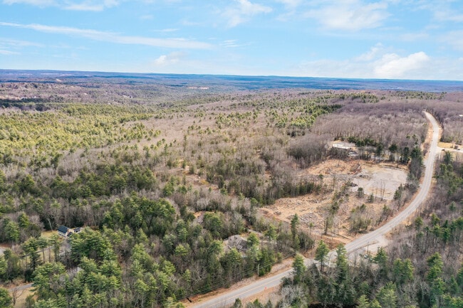
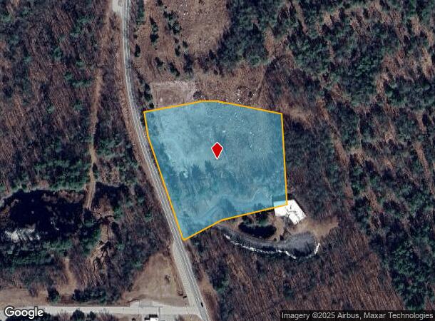
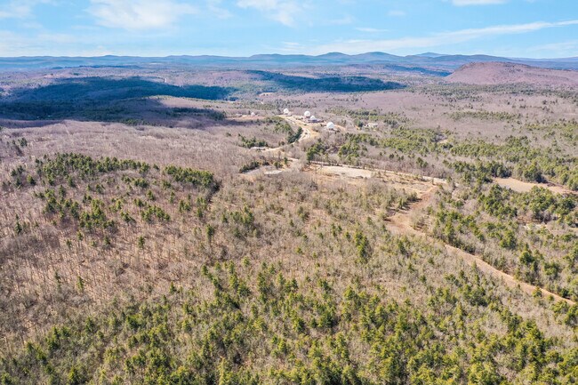
Property Record
Chestnut Hill Rd, New Boston, NH 03070
NEARBY LISTINGS FOR SALE OR LEASE
Property Detail
Chestnut Hill Rd
NBOS-000015-000032-000004
Hillsborough
Multipleuses
New Hampshire
X
4
33011C0355D
5 AC
2024
Hillsborough
2024
Boston
020000
Manchester-Nashua, NH
DEMOGRAPHICS near Chestnut Hill Rd
1 Mile
3 Mile
5 Mile
2024 Total Population
386
5,661
22,383
2029 Population
396
5,803
22,943
Pop Growth 2024-2029
+ 2.59%
+ 2.51%
+ 2.50%
Average Age
40
40
41
2024 Total Households
125
1,821
7,486
HH Growth 2024-2029
+ 3.20%
+ 2.53%
+ 2.55%
Median Household Inc
$151,042
$160,725
$149,238
Avg Household Size
3.10
3.10
2.90
2024 Avg HH Vehicles
3.00
3.00
2.00
Median Home Value
$508,475
$569,035
$503,442
Median Year Built
1991
1990
1985
Nearby Places
Map Layers
Map Styles
 Street
 Aerial
- Restaurants
- Banks
- Shops
- Fitness
- Groceries
PUBLIC TRANSPORTATION
AIRPORT
Manchester Boston Regional
DRIVE
WALK
Distance
Manchester Boston Regional
29 min
12.8 mi
Freight Ports
Port of Boston
DRIVE
WALK
Distance
Port of Boston
101 min
65.2 mi
SALE & LEASE HISTORY
LISTING DATE
SALE/LEASE

Aug 08, 2017
For Sale
Nearby Properties
Address
Land Use
TOTAL SIZE
Lot Size
Zoning
Address
Land Use
TOTAL SIZE
Lot Size
Zoning
38,993 SF
1,637.30 AC
FCD
Address
Land Use
TOTAL SIZE
Lot Size
Zoning
21,499 SF
18.40 AC
RA
Address
Land Use
TOTAL SIZE
Lot Size
Zoning
193.77 AC
RA
Address
Land Use
TOTAL SIZE
Lot Size
Zoning
665 AC
NR
Address
Land Use
TOTAL SIZE
Lot Size
Zoning
1,908 SF
74 AC
RA
Address
Land Use
TOTAL SIZE
Lot Size
Zoning
4,264 SF
2.30 AC
RA
Address
Land Use
TOTAL SIZE
Lot Size
Zoning
117 AC
NR
Address
Land Use
TOTAL SIZE
Lot Size
Zoning
2.53 AC
CON
Address
Land Use
TOTAL SIZE
Lot Size
Zoning
10,631 SF
8.33 AC
COM
Address
Land Use
TOTAL SIZE
Lot Size
Zoning
436.85 AC
NR
Address
Land Use
TOTAL SIZE
Lot Size
Zoning
0.57 AC
CON
Address
Land Use
TOTAL SIZE
Lot Size
Zoning
4,483 SF
2.97 AC
RA
Address
Land Use
TOTAL SIZE
Lot Size
Zoning
4,507 SF
2.25 AC
RA
Address
Land Use
TOTAL SIZE
Lot Size
Zoning
3,081 SF
0.21 AC
BD
Address
Land Use
TOTAL SIZE
Lot Size
Zoning
110 AC
CON
Address
Land Use
TOTAL SIZE
Lot Size
Zoning
Address
Land Use
TOTAL SIZE
Lot Size
Zoning
Address
Land Use
TOTAL SIZE
Lot Size
Zoning
0.27 AC
CON
Address
Land Use
TOTAL SIZE
Lot Size
Zoning
4,901 SF
7.13 AC
RA
Address
Land Use
TOTAL SIZE
Lot Size
Zoning
2,986 SF
0.97 AC
NR
Address
Land Use
TOTAL SIZE
Lot Size
Zoning
0.37 AC
CON
Address
Land Use
TOTAL SIZE
Lot Size
Zoning
4,969 SF
5.41 AC
RA
Address
Land Use
TOTAL SIZE
Lot Size
Zoning
31.84 AC
RA
Address
Land Use
TOTAL SIZE
Lot Size
Zoning
137 AC
CON
Address
Land Use
TOTAL SIZE
Lot Size
Zoning
3,777 SF
4 AC
RA
Address
Land Use
TOTAL SIZE
Lot Size
Zoning
1,344 SF
5.10 AC
RA
Address
Land Use
TOTAL SIZE
Lot Size
Zoning
4,206 SF
3 AC
RA
Address
Land Use
TOTAL SIZE
Lot Size
Zoning
3,745 SF
10.23 AC
RA
Address
Land Use
TOTAL SIZE
Lot Size
Zoning
4,282 SF
5.42 AC
RA
Address
Land Use
TOTAL SIZE
Lot Size
Zoning
66.06 AC
NR
The World's #1 Commercial Real Estate Marketplace
Connect with us
© 2025 CoStar Group
The information above has been obtained from sources believed reliable. While we do not doubt its accuracy we have not verified it and make no guarantee, warranty or representation about it. It is your responsibility to independently confirm its accuracy and completeness. Any projections, opinions, assumptions, or estimates used are for example only and do not represent the current or future performance of the property. The value of this transaction to you depends on tax and other factors which should be evaluated by your tax, financial, and legal advisors. You and your advisors should conduct a careful, independent investigation of the property to determine to your satisfaction the suitability of the property for your needs.