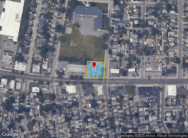
Property Record
340 Hempstead Tpke, West Hempstead, NY 11552
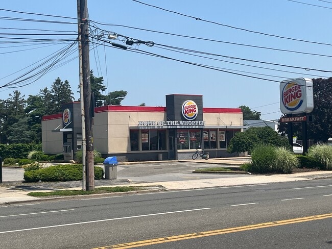
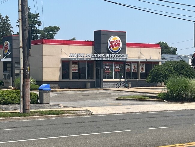
This Property Is For Sale
NEARBY LISTINGS FOR SALE OR LEASE
Property Detail
340 Hempstead Tpke
Nassau County-Suffolk County, NY
Amended Map Of Part Of West Hempstead Ma
2089-33-542-00-0053-0
TOWN #1 SCH DIST 027
Restaurantdrivein
Nassau
X
New York
36059C0210G
53
2025
0.60 AC
2025
Central Nassau
406100
Long Island (New York)
2,314 SF
DEMOGRAPHICS near 340 Hempstead Tpke
1 Mile
3 Mile
5 Mile
2024 Total Population
23,003
244,057
667,973
2029 Population
22,443
238,765
648,818
Pop Growth 2024-2029
(2.43%)
(2.17%)
(2.87%)
Average Age
41
40
42
2024 Total Households
7,420
75,460
210,320
HH Growth 2024-2029
(2.53%)
(2.20%)
(3.00%)
Median Household Inc
$131,391
$117,296
$116,663
Avg Household Size
3.10
3.10
3.00
2024 Avg HH Vehicles
2.00
2.00
2.00
Median Home Value
$663,195
$651,354
$645,484
Median Year Built
1950
1952
1951
Nearby Places
- Restaurants
- Banks
- Shops
- Fitness
- Groceries
PUBLIC TRANSPORTATION
COMMUTER RAIL
West Hempstead Station (West Hempstead Branch - Long Island Rail Road)
DRIVE
WALK
Distance
West Hempstead Station (West Hempstead Branch - Long Island Rail Road)
2 min
14 min
0.7 mi
Hempstead Gardens Station (West Hempstead Branch - Long Island Rail Road)
DRIVE
WALK
Distance
Hempstead Gardens Station (West Hempstead Branch - Long Island Rail Road)
3 min
17 min
0.9 mi
AIRPORT
John F Kennedy International
DRIVE
WALK
Distance
John F Kennedy International
20 min
12.3 mi
LaGuardia
DRIVE
WALK
Distance
LaGuardia
27 min
15.3 mi
Westchester County
DRIVE
WALK
Distance
Westchester County
55 min
36.8 mi
Freight Ports
NY - Red Hook Container Terminal
DRIVE
WALK
Distance
NY - Red Hook Container Terminal
38 min
23.4 mi
Nearby Properties
Address
Land Use
TOTAL SIZE
Lot Size
Zoning
Address
Land Use
TOTAL SIZE
Lot Size
Zoning
5,322,666 SF
86.10 AC
Address
Land Use
TOTAL SIZE
Lot Size
Zoning
202.54 AC
Address
Land Use
TOTAL SIZE
Lot Size
Zoning
1,197,283 SF
64.50 AC
Address
Land Use
TOTAL SIZE
Lot Size
Zoning
574,353 SF
65 AC
Address
Land Use
TOTAL SIZE
Lot Size
Zoning
186 AC
Address
Land Use
TOTAL SIZE
Lot Size
Zoning
556,575 SF
11.46 AC
Address
Land Use
TOTAL SIZE
Lot Size
Zoning
962,971 SF
18.90 AC
Address
Land Use
TOTAL SIZE
Lot Size
Zoning
29,224 SF
1.33 AC
Address
Land Use
TOTAL SIZE
Lot Size
Zoning
277,200 SF
21.03 AC
Address
Land Use
TOTAL SIZE
Lot Size
Zoning
130,720 SF
48.60 AC
Address
Land Use
TOTAL SIZE
Lot Size
Zoning
46,404 SF
38.43 AC
Address
Land Use
TOTAL SIZE
Lot Size
Zoning
63,600 SF
2 AC
Address
Land Use
TOTAL SIZE
Lot Size
Zoning
182,129 SF
1.51 AC
Address
Land Use
TOTAL SIZE
Lot Size
Zoning
116,998 SF
26.35 AC
Address
Land Use
TOTAL SIZE
Lot Size
Zoning
399,955 SF
13.63 AC
Address
Land Use
TOTAL SIZE
Lot Size
Zoning
29,998 SF
22.49 AC
Address
Land Use
TOTAL SIZE
Lot Size
Zoning
76.10 AC
Address
Land Use
TOTAL SIZE
Lot Size
Zoning
83.42 AC
Address
Land Use
TOTAL SIZE
Lot Size
Zoning
126,558 SF
12.76 AC
Address
Land Use
TOTAL SIZE
Lot Size
Zoning
441,888 SF
22.09 AC
Address
Land Use
TOTAL SIZE
Lot Size
Zoning
23,148 SF
18.67 AC
Address
Land Use
TOTAL SIZE
Lot Size
Zoning
293,443 SF
21.86 AC
Address
Land Use
TOTAL SIZE
Lot Size
Zoning
252,032 SF
4.72 AC
Address
Land Use
TOTAL SIZE
Lot Size
Zoning
80,819 SF
6.90 AC
Address
Land Use
TOTAL SIZE
Lot Size
Zoning
31,828 SF
14.74 AC
Address
Land Use
TOTAL SIZE
Lot Size
Zoning
1,620 SF
0.14 AC
Address
Land Use
TOTAL SIZE
Lot Size
Zoning
170,753 SF
26.64 AC
Address
Land Use
TOTAL SIZE
Lot Size
Zoning
86,903 SF
29.84 AC
Address
Land Use
TOTAL SIZE
Lot Size
Zoning
304,075 SF
14.95 AC
Address
Land Use
TOTAL SIZE
Lot Size
Zoning
63.32 AC
The World's #1 Commercial Real Estate Marketplace
Connect with us
© 2025 CoStar Group
The information above has been obtained from sources believed reliable. While we do not doubt its accuracy we have not verified it and make no guarantee, warranty or representation about it. It is your responsibility to independently confirm its accuracy and completeness. Any projections, opinions, assumptions, or estimates used are for example only and do not represent the current or future performance of the property. The value of this transaction to you depends on tax and other factors which should be evaluated by your tax, financial, and legal advisors. You and your advisors should conduct a careful, independent investigation of the property to determine to your satisfaction the suitability of the property for your needs.