Property Record
340 N Franklin St, Janesville, WI 53548
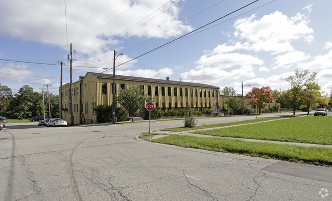
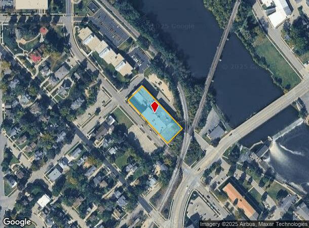
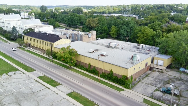
This Property Is For Sale
NEARBY LISTINGS FOR SALE OR LEASE
Property Detail
340 N Franklin St
Janesville-Beloit, WI
Smith & Bailey's Add
013-6100193
Rock
Sfr
Wisconsin
X
0.88 AC
55105C0192E
Rock County
9,660 SF
Milwaukee/Madison
DEMOGRAPHICS near 340 N Franklin St
1 Mile
3 Mile
5 Mile
2024 Total Population
13,213
50,556
69,785
2029 Population
13,365
51,021
70,474
Pop Growth 2024-2029
+ 1.15%
+ 0.92%
+ 0.99%
Average Age
38
40
41
2024 Total Households
5,602
21,378
28,898
HH Growth 2024-2029
+ 1.29%
+ 0.98%
+ 1.02%
Median Household Inc
$50,202
$61,466
$66,840
Avg Household Size
2.20
2.30
2.30
2024 Avg HH Vehicles
2.00
2.00
2.00
Median Home Value
$149,520
$166,739
$187,886
Median Year Built
1948
1966
1972
Nearby Places
Map Layers
Map Styles
 Street
 Aerial
- Restaurants
- Banks
- Shops
- Fitness
- Groceries
PUBLIC TRANSPORTATION
AIRPORT
Dane County Regional/Truax Field
DRIVE
WALK
Distance
Dane County Regional/Truax Field
57 min
43.4 mi
Chicago/Rockford International
DRIVE
WALK
Distance
Chicago/Rockford International
59 min
44.7 mi
Nearby Properties
Address
Land Use
TOTAL SIZE
Lot Size
Zoning
Address
Land Use
TOTAL SIZE
Lot Size
Zoning
56.41 AC
M2
Address
Land Use
TOTAL SIZE
Lot Size
Zoning
32,518 SF
26.74 AC
B4
Address
Land Use
TOTAL SIZE
Lot Size
Zoning
31,064 SF
11.57 AC
R3
Address
Land Use
TOTAL SIZE
Lot Size
Zoning
12,620 SF
8.05 AC
R3
Address
Land Use
TOTAL SIZE
Lot Size
Zoning
48,110 SF
13.04 AC
R3
Address
Land Use
TOTAL SIZE
Lot Size
Zoning
135,322 SF
18.41 AC
B2
Address
Land Use
TOTAL SIZE
Lot Size
Zoning
2,800 SF
69 AC
M1
Address
Land Use
TOTAL SIZE
Lot Size
Zoning
18,480 SF
14.50 AC
O1
Address
Land Use
TOTAL SIZE
Lot Size
Zoning
70,000 SF
63.05 AC
M1
Address
Land Use
TOTAL SIZE
Lot Size
Zoning
98,370 SF
8.64 AC
B4
Address
Land Use
TOTAL SIZE
Lot Size
Zoning
7.52 AC
R3
Address
Land Use
TOTAL SIZE
Lot Size
Zoning
Address
Land Use
TOTAL SIZE
Lot Size
Zoning
14,580 SF
28.75 AC
M1
Address
Land Use
TOTAL SIZE
Lot Size
Zoning
42.07 AC
Address
Land Use
TOTAL SIZE
Lot Size
Zoning
17,183 SF
6.65 AC
B3
Address
Land Use
TOTAL SIZE
Lot Size
Zoning
24,960 SF
8.85 AC
B4
Address
Land Use
TOTAL SIZE
Lot Size
Zoning
12.42 AC
M1
Address
Land Use
TOTAL SIZE
Lot Size
Zoning
110,820 SF
10.62 AC
B4
Address
Land Use
TOTAL SIZE
Lot Size
Zoning
17.14 AC
M1
Address
Land Use
TOTAL SIZE
Lot Size
Zoning
1,020 SF
9.77 AC
B4
Address
Land Use
TOTAL SIZE
Lot Size
Zoning
2.30 AC
Address
Land Use
TOTAL SIZE
Lot Size
Zoning
101,195 SF
1.40 AC
B6
Address
Land Use
TOTAL SIZE
Lot Size
Zoning
2,662 SF
4.48 AC
B4
Address
Land Use
TOTAL SIZE
Lot Size
Zoning
20.84 AC
M2
Address
Land Use
TOTAL SIZE
Lot Size
Zoning
2,480 SF
16.27 AC
M2
Address
Land Use
TOTAL SIZE
Lot Size
Zoning
49,524 SF
1.57 AC
B6
Address
Land Use
TOTAL SIZE
Lot Size
Zoning
94,053 SF
4.52 AC
R3
Address
Land Use
TOTAL SIZE
Lot Size
Zoning
9,246 SF
0.59 AC
B5
Address
Land Use
TOTAL SIZE
Lot Size
Zoning
20,360 SF
2.13 AC
B4
Address
Land Use
TOTAL SIZE
Lot Size
Zoning
24,944 SF
5.08 AC
R3
The World's #1 Commercial Real Estate Marketplace
Connect with us
© 2025 CoStar Group
The information above has been obtained from sources believed reliable. While we do not doubt its accuracy we have not verified it and make no guarantee, warranty or representation about it. It is your responsibility to independently confirm its accuracy and completeness. Any projections, opinions, assumptions, or estimates used are for example only and do not represent the current or future performance of the property. The value of this transaction to you depends on tax and other factors which should be evaluated by your tax, financial, and legal advisors. You and your advisors should conduct a careful, independent investigation of the property to determine to your satisfaction the suitability of the property for your needs.