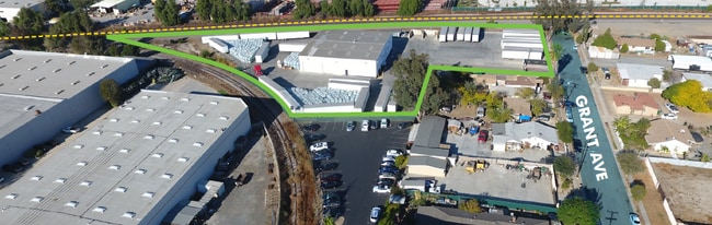
Property Record
340 N Grant Ave, Corona, CA 92882

Property Detail
340 N Grant Ave
Riverside-San Bernardino-Ontario, CA
2.24 ACRES M/L IN LOTS 15 & 16 MB 011/076 EL JARDIN DE CORONA AND POR PAR 7 PM 073/088 PM 14285
118-060-039
Riverside
Lightindustrial
California
C and X Area of minimal flood hazard, usually depicted on FIRMs as above the 500-year flood level.
16
2024
2.24 AC
2025
Corona/Eastvale
041500
Inland Empire (California)
10,000 SF
NEARBY LISTINGS FOR SALE OR LEASE
-
-
No Photo
-
-
-
-
-
-
View all Corona listings for lease on LoopNet.com
DEMOGRAPHICS near 340 N Grant Ave
1 mile
3 mile
5 mile
2025 Total Population
14,124
106,773
217,381
2030 Population
14,316
108,418
220,962
Pop Growth 2025-2030
+ 1.36%
+ 1.54%
+ 1.65%
Average Age
34
38
38
2025 Total Households
4,010
30,364
61,585
HH Growth 2025-2030
+ 0.60%
+ 1.01%
+ 1.15%
Median Household Inc
$83,161
$99,280
$112,688
Avg Household Size
3.40
3.20
3.30
2025 Avg HH Vehicles
2.00
2.00
3.00
Median Home Value
$675,681
$718,633
$731,834
Median Year Built
1985
1982
1988
Nearby Places
Map Layers
Map Styles
 Street
 Aerial
Layers
 Traffic
 Biking
Places
Listings with unknown addresses are not visible on the map
- Restaurants
- Banks
- Shops
- Fitness
- Groceries
PUBLIC TRANSPORTATION
COMMUTER RAIL
North Main Corona (91 Line - Southern California Regional Rail Authority (Metrolink), Inland Empire-Orange County Line - Southern California Regional Rail Authority (Metrolink))
Drive
Walk
Distance
North Main Corona (91 Line - Southern California Regional Rail Authority (Metrolink), Inland Empire-Orange County Line - Southern California Regional Rail Authority (Metrolink))
4 min
1.5 mi
West Corona (91 Line - Southern California Regional Rail Authority (Metrolink), Inland Empire-Orange County Line - Southern California Regional Rail Authority (Metrolink))
Drive
Walk
Distance
West Corona (91 Line - Southern California Regional Rail Authority (Metrolink), Inland Empire-Orange County Line - Southern California Regional Rail Authority (Metrolink))
6 min
2.8 mi
AIRPORT
Ontario International
Drive
Walk
Distance
Ontario International
24 min
16.7 mi
John Wayne/Orange County
Drive
Walk
Distance
John Wayne/Orange County
35 min
27.8 mi
Freight Ports
Port of Long Beach
Drive
Walk
Distance
Port of Long Beach
55 min
41.8 mi
SALE & LEASE HISTORY
LISTING DATE
SALE/LEASE

Dec 02, 2025
For Lease
Apr 08, 2021
For Lease
Nearby Properties
Address
Land Use
TOTAL SIZE
Lot Size
Zoning
Address
Land Use
TOTAL SIZE
Lot Size
Zoning
12.69 AC
Address
Land Use
TOTAL SIZE
Lot Size
Zoning
91,619 SF
12.54 AC
HDR
Address
Land Use
TOTAL SIZE
Lot Size
Zoning
29,695 SF
18.71 AC
R3
Address
Land Use
TOTAL SIZE
Lot Size
Zoning
364,193 SF
23.77 AC
Address
Land Use
TOTAL SIZE
Lot Size
Zoning
263,872 SF
12.87 AC
Address
Land Use
TOTAL SIZE
Lot Size
Zoning
24,144 SF
13.34 AC
R3
Address
Land Use
TOTAL SIZE
Lot Size
Zoning
245,658 SF
15.38 AC
PD
Address
Land Use
TOTAL SIZE
Lot Size
Zoning
182,066 SF
9.31 AC
Address
Land Use
TOTAL SIZE
Lot Size
Zoning
421,898 SF
3 AC
Address
Land Use
TOTAL SIZE
Lot Size
Zoning
217,299 SF
7.41 AC
Address
Land Use
TOTAL SIZE
Lot Size
Zoning
141,280 SF
9.31 AC
Address
Land Use
TOTAL SIZE
Lot Size
Zoning
171,707 SF
8.55 AC
Address
Land Use
TOTAL SIZE
Lot Size
Zoning
149,389 SF
6.72 AC
Address
Land Use
TOTAL SIZE
Lot Size
Zoning
154,581 SF
8.30 AC
Address
Land Use
TOTAL SIZE
Lot Size
Zoning
152,756 SF
7.07 AC
Address
Land Use
TOTAL SIZE
Lot Size
Zoning
159,517 SF
7.81 AC
Address
Land Use
TOTAL SIZE
Lot Size
Zoning
140,216 SF
6.43 AC
Address
Land Use
TOTAL SIZE
Lot Size
Zoning
145,424 SF
7.23 AC
Address
Land Use
TOTAL SIZE
Lot Size
Zoning
111,862 SF
9.98 AC
A
Address
Land Use
TOTAL SIZE
Lot Size
Zoning
357,900 SF
18.93 AC
Address
Land Use
TOTAL SIZE
Lot Size
Zoning
311,297 SF
13.39 AC
Address
Land Use
TOTAL SIZE
Lot Size
Zoning
482,479 SF
26.14 AC
M2
Address
Land Use
TOTAL SIZE
Lot Size
Zoning
63,130 SF
10.20 AC
R3
Address
Land Use
TOTAL SIZE
Lot Size
Zoning
203,476 SF
10.40 AC
C3
Address
Land Use
TOTAL SIZE
Lot Size
Zoning
105,813 SF
3.54 AC
Address
Land Use
TOTAL SIZE
Lot Size
Zoning
105,813 SF
3.50 AC
A144
Address
Land Use
TOTAL SIZE
Lot Size
Zoning
117,720 SF
9.69 AC
Address
Land Use
TOTAL SIZE
Lot Size
Zoning
110,334 SF
11 AC
NCD
Address
Land Use
TOTAL SIZE
Lot Size
Zoning
128,674 SF
6.71 AC
M1
Address
Land Use
TOTAL SIZE
Lot Size
Zoning
116,654 SF
6.03 AC
The World's #1 Commercial Real Estate Marketplace
Connect with us
© 2026 CoStar Group
The information above has been obtained from sources believed reliable. While we do not doubt its accuracy we have not verified it and make no guarantee, warranty or representation about it. It is your responsibility to independently confirm its accuracy and completeness. Any projections, opinions, assumptions, or estimates used are for example only and do not represent the current or future performance of the property. The value of this transaction to you depends on tax and other factors which should be evaluated by your tax, financial, and legal advisors. You and your advisors should conduct a careful, independent investigation of the property to determine to your satisfaction the suitability of the property for your needs.