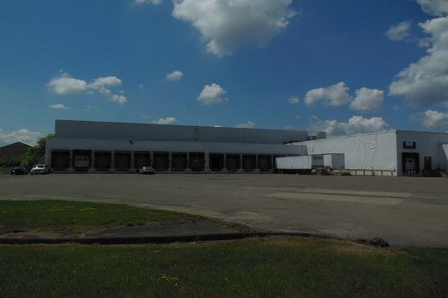
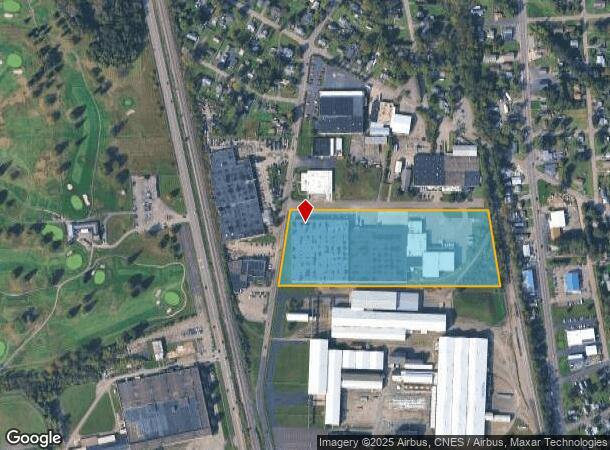
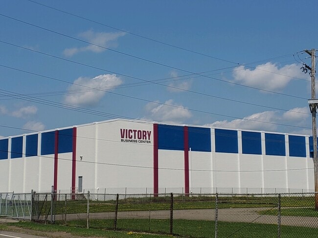
Property Record
340 Upper Oakwood Ave, Elmira, NY 14903

Current Lease Availabilities
Industrial LEASE
$4.25 - $5.50 SF/YR
4,000 - 83,768 SF
NEARBY LISTINGS FOR SALE OR LEASE
Property Detail
340 Upper Oakwood Ave
Elmira, NY
Chemung
073489-069-013-0002-013-000-0000
New York
Warehouse
13.000
2025
12.40 AC
2024
Ithaca/Elmira
010800
Other Market Areas
274,678 SF
DEMOGRAPHICS near 340 Upper Oakwood Ave
1 Mile
3 Mile
5 Mile
2024 Total Population
5,168
23,875
57,674
2029 Population
4,983
23,257
56,304
Pop Growth 2024-2029
(3.58%)
(2.59%)
(2.38%)
Average Age
42
42
42
2024 Total Households
2,400
10,026
24,702
HH Growth 2024-2029
(3.79%)
(2.75%)
(2.49%)
Median Household Inc
$54,766
$53,701
$57,190
Avg Household Size
2.10
2.20
2.20
2024 Avg HH Vehicles
2.00
2.00
2.00
Median Home Value
$101,329
$103,392
$123,932
Median Year Built
1949
1952
1952
Nearby Places
- Restaurants
- Banks
- Shops
- Fitness
- Groceries
PUBLIC TRANSPORTATION
AIRPORT
Elmira/Corning Regional
DRIVE
WALK
Distance
Elmira/Corning Regional
14 min
7.5 mi
Freight Ports
Albany, NY Port
DRIVE
WALK
Distance
Albany, NY Port
240 min
198.3 mi
Nearby Properties
Address
Land Use
TOTAL SIZE
Lot Size
Zoning
Address
Land Use
TOTAL SIZE
Lot Size
Zoning
59 AC
UNZONED
Address
Land Use
TOTAL SIZE
Lot Size
Zoning
308,479 SF
28.20 AC
HA
Address
Land Use
TOTAL SIZE
Lot Size
Zoning
290,934 SF
13.50 AC
HED
Address
Land Use
TOTAL SIZE
Lot Size
Zoning
111,633 SF
30.02 AC
05 - COMME
Address
Land Use
TOTAL SIZE
Lot Size
Zoning
60,899 SF
207.30 AC
TH02
Address
Land Use
TOTAL SIZE
Lot Size
Zoning
6,718 SF
83.70 AC
06 - INDUS
Address
Land Use
TOTAL SIZE
Lot Size
Zoning
213,707 SF
21.34 AC
TH08
Address
Land Use
TOTAL SIZE
Lot Size
Zoning
53,096 SF
10.32 AC
TH08
Address
Land Use
TOTAL SIZE
Lot Size
Zoning
Address
Land Use
TOTAL SIZE
Lot Size
Zoning
Address
Land Use
TOTAL SIZE
Lot Size
Zoning
25,388 SF
58.90 AC
RAA
Address
Land Use
TOTAL SIZE
Lot Size
Zoning
13,612 SF
15.30 AC
VH05
Address
Land Use
TOTAL SIZE
Lot Size
Zoning
18.61 AC
IB
Address
Land Use
TOTAL SIZE
Lot Size
Zoning
52,628 SF
2.40 AC
HED
Address
Land Use
TOTAL SIZE
Lot Size
Zoning
124,645 SF
12.09 AC
05 - COMME
Address
Land Use
TOTAL SIZE
Lot Size
Zoning
103,764 SF
31.98 AC
R2
Address
Land Use
TOTAL SIZE
Lot Size
Zoning
183,919 SF
40.70 AC
TH02
Address
Land Use
TOTAL SIZE
Lot Size
Zoning
55,376 SF
32.80 AC
VH02
Address
Land Use
TOTAL SIZE
Lot Size
Zoning
128,605 SF
16.38 AC
05 - COMME
Address
Land Use
TOTAL SIZE
Lot Size
Zoning
7,203 SF
5.10 AC
06 - INDUS
Address
Land Use
TOTAL SIZE
Lot Size
Zoning
9,072 SF
7.13 AC
VH04
Address
Land Use
TOTAL SIZE
Lot Size
Zoning
99,188 SF
16.80 AC
R2
Address
Land Use
TOTAL SIZE
Lot Size
Zoning
51,280 SF
6.44 AC
TH08
Address
Land Use
TOTAL SIZE
Lot Size
Zoning
63,178 SF
3.32 AC
05 - COMME
Address
Land Use
TOTAL SIZE
Lot Size
Zoning
136,977 SF
2.55 AC
HED
Address
Land Use
TOTAL SIZE
Lot Size
Zoning
194,626 SF
10.20 AC
RAA
Address
Land Use
TOTAL SIZE
Lot Size
Zoning
5,562 SF
22.64 AC
RD
Address
Land Use
TOTAL SIZE
Lot Size
Zoning
248,126 SF
20.60 AC
VH05
Address
Land Use
TOTAL SIZE
Lot Size
Zoning
14.10 AC
M
Address
Land Use
TOTAL SIZE
Lot Size
Zoning
420,041 SF
46.55 AC
VH08
The World's #1 Commercial Real Estate Marketplace
Connect with us
© 2025 CoStar Group
The information above has been obtained from sources believed reliable. While we do not doubt its accuracy we have not verified it and make no guarantee, warranty or representation about it. It is your responsibility to independently confirm its accuracy and completeness. Any projections, opinions, assumptions, or estimates used are for example only and do not represent the current or future performance of the property. The value of this transaction to you depends on tax and other factors which should be evaluated by your tax, financial, and legal advisors. You and your advisors should conduct a careful, independent investigation of the property to determine to your satisfaction the suitability of the property for your needs.