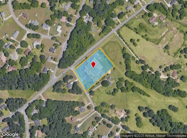
Property Record
340 Wilkerson Rd, Rex, GA 30273
NEARBY LISTINGS FOR SALE OR LEASE
Property Detail
340 Wilkerson Rd
0026-01-036-001
LAND LOT: 166 /LAND DISTRICT: 12
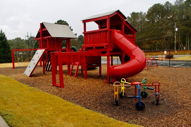
Daycare
Henry
X
Georgia
13063C0082F
166
2025
2.58 AC
2025
Forest Park/Morrow
070109
Atlanta
12,943 SF
Atlanta-Sandy Springs-Roswell, GA
DEMOGRAPHICS near 340 Wilkerson Rd
1 Mile
3 Mile
5 Mile
2024 Total Population
5,243
42,811
123,813
2029 Population
5,374
44,075
126,918
Pop Growth 2024-2029
+ 2.50%
+ 2.95%
+ 2.51%
Average Age
40
38
38
2024 Total Households
1,812
14,561
43,232
HH Growth 2024-2029
+ 2.65%
+ 3.04%
+ 2.60%
Median Household Inc
$68,156
$65,387
$61,316
Avg Household Size
2.80
2.90
2.80
2024 Avg HH Vehicles
2.00
2.00
2.00
Median Home Value
$171,564
$189,429
$187,859
Median Year Built
1997
1994
1993
Nearby Places
Map Layers
Map Styles
 Street
 Aerial
- Restaurants
- Banks
- Shops
- Fitness
- Groceries
PUBLIC TRANSPORTATION
AIRPORT
Hartsfield - Jackson Atlanta International
DRIVE
WALK
Distance
Hartsfield - Jackson Atlanta International
26 min
12.3 mi
Freight Ports
Georgia Ports - Savannah
DRIVE
WALK
Distance
Georgia Ports - Savannah
265 min
234.7 mi
SALE & LEASE HISTORY
LISTING DATE
SALE/LEASE

Jan 12, 2022
For Sale
Nearby Properties
Address
Land Use
TOTAL SIZE
Lot Size
Zoning
Address
Land Use
TOTAL SIZE
Lot Size
Zoning
659,547 SF
31.20 AC
HI
Address
Land Use
TOTAL SIZE
Lot Size
Zoning
332,442 SF
28.80 AC
HI
Address
Land Use
TOTAL SIZE
Lot Size
Zoning
229,829 SF
24.15 AC
HI
Address
Land Use
TOTAL SIZE
Lot Size
Zoning
142,742 SF
27.10 AC
RS110
Address
Land Use
TOTAL SIZE
Lot Size
Zoning
259,168 SF
29.08 AC
GB
Address
Land Use
TOTAL SIZE
Lot Size
Zoning
312,798 SF
21.38 AC
HI
Address
Land Use
TOTAL SIZE
Lot Size
Zoning
400,000 SF
42.87 AC
HI
Address
Land Use
TOTAL SIZE
Lot Size
Zoning
271,919 SF
17.89 AC
HI
Address
Land Use
TOTAL SIZE
Lot Size
Zoning
214,055 SF
55.08 AC
HI
Address
Land Use
TOTAL SIZE
Lot Size
Zoning
95,132 SF
20.76 AC
AG
Address
Land Use
TOTAL SIZE
Lot Size
Zoning
127,735 SF
20.74 AC
M1
Address
Land Use
TOTAL SIZE
Lot Size
Zoning
110,621 SF
20.57 AC
HI
Address
Land Use
TOTAL SIZE
Lot Size
Zoning
120,015 SF
26 AC
RS110
Address
Land Use
TOTAL SIZE
Lot Size
Zoning
6,425 SF
64.33 AC
HI
Address
Land Use
TOTAL SIZE
Lot Size
Zoning
2,380 SF
41.50 AC
RS180
Address
Land Use
TOTAL SIZE
Lot Size
Zoning
234,192 SF
23 AC
HI
Address
Land Use
TOTAL SIZE
Lot Size
Zoning
68,418 SF
15.10 AC
RS110
Address
Land Use
TOTAL SIZE
Lot Size
Zoning
80,431 SF
9.53 AC
C2
Address
Land Use
TOTAL SIZE
Lot Size
Zoning
101,848 SF
19.95 AC
C1
Address
Land Use
TOTAL SIZE
Lot Size
Zoning
38,941 SF
38.90 AC
RS110
Address
Land Use
TOTAL SIZE
Lot Size
Zoning
63,548 SF
9.20 AC
GB
Address
Land Use
TOTAL SIZE
Lot Size
Zoning
56,286 SF
13.55 AC
GB
Address
Land Use
TOTAL SIZE
Lot Size
Zoning
68,272 SF
7.52 AC
C1
Address
Land Use
TOTAL SIZE
Lot Size
Zoning
4,288 SF
77.44 AC
M2
Address
Land Use
TOTAL SIZE
Lot Size
Zoning
82,557 SF
4.89 AC
C3
Address
Land Use
TOTAL SIZE
Lot Size
Zoning
151 SF
17.96 AC
RMH
Address
Land Use
TOTAL SIZE
Lot Size
Zoning
70,667 SF
8.70 AC
AG
Address
Land Use
TOTAL SIZE
Lot Size
Zoning
62,520 SF
18.01 AC
Address
Land Use
TOTAL SIZE
Lot Size
Zoning
7,336 SF
8.53 AC
GB
Address
Land Use
TOTAL SIZE
Lot Size
Zoning
5,168 SF
99.20 AC
C
The World's #1 Commercial Real Estate Marketplace
Connect with us
© 2026 CoStar Group
The information above has been obtained from sources believed reliable. While we do not doubt its accuracy we have not verified it and make no guarantee, warranty or representation about it. It is your responsibility to independently confirm its accuracy and completeness. Any projections, opinions, assumptions, or estimates used are for example only and do not represent the current or future performance of the property. The value of this transaction to you depends on tax and other factors which should be evaluated by your tax, financial, and legal advisors. You and your advisors should conduct a careful, independent investigation of the property to determine to your satisfaction the suitability of the property for your needs.