Property Record
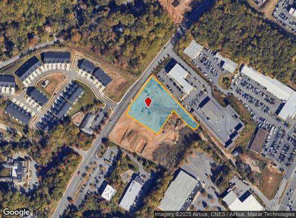
3400 Berkmar Dr, Charlottesville, VA 22901
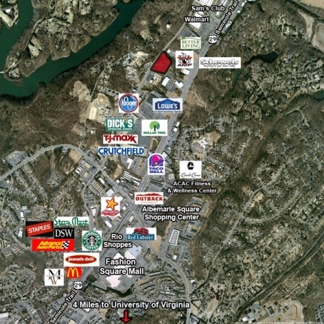

NEARBY LISTINGS FOR SALE OR LEASE
Property Detail
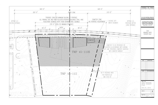
3400 Berkmar Dr
04500-00-00-112E0
Thomas B Lincoln Land Surveyor Inc
Realpropertynec
ACREAGE X
X
Albemarle
51003C0280D
Virginia
2025
1.71 AC
2025
Charlottesville
010802
Other Market Areas
1,076 SF
Charlottesville, VA
DEMOGRAPHICS near 3400 Berkmar Dr
1 Mile
3 Mile
5 Mile
2024 Total Population
3,307
33,730
85,485
2029 Population
3,445
34,874
86,944
Pop Growth 2024-2029
+ 4.17%
+ 3.39%
+ 1.71%
Average Age
42
41
38
2024 Total Households
1,355
14,130
34,106
HH Growth 2024-2029
+ 4.50%
+ 3.89%
+ 1.90%
Median Household Inc
$89,242
$81,618
$78,263
Avg Household Size
2.40
2.30
2.20
2024 Avg HH Vehicles
2.00
2.00
2.00
Median Home Value
$398,725
$391,448
$428,013
Median Year Built
1986
1986
1984
Nearby Places
Map Layers
Map Styles
 Street
 Aerial
- Restaurants
- Banks
- Shops
- Fitness
- Groceries
PUBLIC TRANSPORTATION
COMMUTER RAIL
DRIVE
WALK
Distance
13 min
5.7 mi
AIRPORT
Charlottesville-Albemarle
DRIVE
WALK
Distance
Charlottesville-Albemarle
12 min
4.9 mi
SALE & LEASE HISTORY
LISTING DATE
SALE/LEASE

Aug 02, 2017
For Sale
Nearby Properties
Address
Land Use
TOTAL SIZE
Lot Size
Zoning
Address
Land Use
TOTAL SIZE
Lot Size
Zoning
3,803 SF
266.70 AC
CV
Address
Land Use
TOTAL SIZE
Lot Size
Zoning
12,876 SF
32.70 AC
NEIGHBORHO
Address
Land Use
TOTAL SIZE
Lot Size
Zoning
393,960 SF
16.14 AC
NMD
Address
Land Use
TOTAL SIZE
Lot Size
Zoning
46,770 SF
216.69 AC
RURAL AREA
Address
Land Use
TOTAL SIZE
Lot Size
Zoning
Address
Land Use
TOTAL SIZE
Lot Size
Zoning
17.73 AC
R15 RESIDE
Address
Land Use
TOTAL SIZE
Lot Size
Zoning
263,304 SF
9.77 AC
R15 RESIDE
Address
Land Use
TOTAL SIZE
Lot Size
Zoning
226,576 SF
2.72 AC
Address
Land Use
TOTAL SIZE
Lot Size
Zoning
249,740 SF
42.40 AC
CM
Address
Land Use
TOTAL SIZE
Lot Size
Zoning
60,697 SF
12.93 AC
PLANNED DE
Address
Land Use
TOTAL SIZE
Lot Size
Zoning
288,555 SF
30.98 AC
PDSC
Address
Land Use
TOTAL SIZE
Lot Size
Zoning
56,861 SF
41.07 AC
PLANNED UN
Address
Land Use
TOTAL SIZE
Lot Size
Zoning
103,624 SF
9.49 AC
NX-10
Address
Land Use
TOTAL SIZE
Lot Size
Zoning
366,877 SF
25.42 AC
LIGHT INDU
Address
Land Use
TOTAL SIZE
Lot Size
Zoning
154,479 SF
13.61 AC
NEIGHBORHO
Address
Land Use
TOTAL SIZE
Lot Size
Zoning
58,538 SF
6.13 AC
HIGHWAY CO
Address
Land Use
TOTAL SIZE
Lot Size
Zoning
177,443 SF
13.08 AC
HIGHWAY CO
Address
Land Use
TOTAL SIZE
Lot Size
Zoning
138,559 SF
16.02 AC
NX-10
Address
Land Use
TOTAL SIZE
Lot Size
Zoning
85,280 SF
15.33 AC
CM
Address
Land Use
TOTAL SIZE
Lot Size
Zoning
2,400 SF
8.65 AC
R-C
Address
Land Use
TOTAL SIZE
Lot Size
Zoning
80,960 SF
19.54 AC
R6 RESIDEN
Address
Land Use
TOTAL SIZE
Lot Size
Zoning
84,915 SF
0.97 AC
PLANNED UN
Address
Land Use
TOTAL SIZE
Lot Size
Zoning
144,744 SF
3.85 AC
R15 RESIDE
Address
Land Use
TOTAL SIZE
Lot Size
Zoning
144,720 SF
6.48 AC
R15 RESIDE
Address
Land Use
TOTAL SIZE
Lot Size
Zoning
192,712 SF
18.14 AC
PDSC
Address
Land Use
TOTAL SIZE
Lot Size
Zoning
41,684 SF
5.91 AC
NMD
Address
Land Use
TOTAL SIZE
Lot Size
Zoning
177,673 SF
24.30 AC
PDSC
Address
Land Use
TOTAL SIZE
Lot Size
Zoning
85,270 SF
1.01 AC
NEIGHBORHO
Address
Land Use
TOTAL SIZE
Lot Size
Zoning
103,966 SF
3.11 AC
NX-10
Address
Land Use
TOTAL SIZE
Lot Size
Zoning
123,336 SF
9.06 AC
NX-10
The World's #1 Commercial Real Estate Marketplace
Connect with us
© 2026 CoStar Group
The information above has been obtained from sources believed reliable. While we do not doubt its accuracy we have not verified it and make no guarantee, warranty or representation about it. It is your responsibility to independently confirm its accuracy and completeness. Any projections, opinions, assumptions, or estimates used are for example only and do not represent the current or future performance of the property. The value of this transaction to you depends on tax and other factors which should be evaluated by your tax, financial, and legal advisors. You and your advisors should conduct a careful, independent investigation of the property to determine to your satisfaction the suitability of the property for your needs.