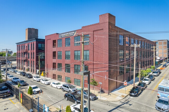
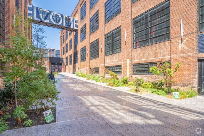
Property Record
3412 J St, Philadelphia, PA 19134

Current Lease Availabilities
NEARBY LISTINGS FOR SALE OR LEASE
Property Detail
3412 J St
881142940
121 6 N OF ONTARIO
Apartment
Philadelphia
X
Pennsylvania
34007C0026F
0.52 AC
2024
Kensington
2026
Philadelphia
019200
Philadelphia-Camden-Wilmington, PA-NJ-DE-MD
44,800 SF
DEMOGRAPHICS near 3412 J St
1 Mile
3 Mile
5 Mile
2024 Total Population
55,203
357,416
931,966
2029 Population
53,392
347,035
907,855
Pop Growth 2024-2029
(3.28%)
(2.90%)
(2.59%)
Average Age
34
36
37
2024 Total Households
18,690
130,991
371,533
HH Growth 2024-2029
(3.50%)
(3.00%)
(2.73%)
Median Household Inc
$34,759
$39,127
$51,560
Avg Household Size
2.80
2.60
2.40
2024 Avg HH Vehicles
1.00
1.00
1.00
Median Home Value
$96,724
$151,878
$189,142
Median Year Built
1946
1947
1949
Nearby Places
- Restaurants
- Banks
- Shops
- Fitness
- Groceries
PUBLIC TRANSPORTATION
TRANSIT/SUBWAY
Tioga (Market-Frankford Line - Southeastern Pennsylvania Transportation Authority Rapid Transit (SEPTA Subway & Trolley))
DRIVE
WALK
Distance
Tioga (Market-Frankford Line - Southeastern Pennsylvania Transportation Authority Rapid Transit (SEPTA Subway & Trolley))
0 min
5 min
0.2 mi
Allegheny - Mfl (Market-Frankford Line - SEPTA)
DRIVE
WALK
Distance
Allegheny - Mfl (Market-Frankford Line - SEPTA)
2 min
7 min
0.4 mi
Allegheny (Mfl) (Market-Frankford Line - Southeastern Pennsylvania Transportation Authority Rapid Transit (SEPTA Subway & Trolley))
DRIVE
WALK
Distance
Allegheny (Mfl) (Market-Frankford Line - Southeastern Pennsylvania Transportation Authority Rapid Transit (SEPTA Subway & Trolley))
2 min
7 min
0.4 mi
Erie-Torresdale (Market-Frankford Line - Southeastern Pennsylvania Transportation Authority Rapid Transit (SEPTA Subway & Trolley))
DRIVE
WALK
Distance
Erie-Torresdale (Market-Frankford Line - Southeastern Pennsylvania Transportation Authority Rapid Transit (SEPTA Subway & Trolley))
2 min
16 min
0.8 mi
Somerset (Market-Frankford Line - Southeastern Pennsylvania Transportation Authority Rapid Transit (SEPTA Subway & Trolley))
DRIVE
WALK
Distance
Somerset (Market-Frankford Line - Southeastern Pennsylvania Transportation Authority Rapid Transit (SEPTA Subway & Trolley))
4 min
18 min
1.0 mi
COMMUTER RAIL
Bridesburg (R7 - Southeastern Pennsylvania Transportation Authority Regional Rail (SEPTA Regional Rail))
DRIVE
WALK
Distance
Bridesburg (R7 - Southeastern Pennsylvania Transportation Authority Regional Rail (SEPTA Regional Rail))
6 min
2.5 mi
North Philadelphia (Broad Street Line - Southeastern Pennsylvania Transportation Authority Rapid Transit (SEPTA Subway & Trolley))
DRIVE
WALK
Distance
North Philadelphia (Broad Street Line - Southeastern Pennsylvania Transportation Authority Rapid Transit (SEPTA Subway & Trolley))
8 min
3.0 mi
AIRPORT
Philadelphia International
DRIVE
WALK
Distance
Philadelphia International
28 min
16.3 mi
Trenton Mercer
DRIVE
WALK
Distance
Trenton Mercer
45 min
29.3 mi
Freight Ports
Port of Philadelphia
DRIVE
WALK
Distance
Port of Philadelphia
6 min
2.5 mi
Nearby Properties
Address
Land Use
TOTAL SIZE
Lot Size
Zoning
Address
Land Use
TOTAL SIZE
Lot Size
Zoning
880,950 SF
27.71 AC
SPENT
Address
Land Use
TOTAL SIZE
Lot Size
Zoning
1.88 AC
SPINS
Address
Land Use
TOTAL SIZE
Lot Size
Zoning
804,000 SF
4.29 AC
CMX3
Address
Land Use
TOTAL SIZE
Lot Size
Zoning
740,701 SF
47.70 AC
I2
Address
Land Use
TOTAL SIZE
Lot Size
Zoning
461,286 SF
2.64 AC
CMX4
Address
Land Use
TOTAL SIZE
Lot Size
Zoning
285,615 SF
1.46 AC
SPINS
Address
Land Use
TOTAL SIZE
Lot Size
Zoning
96,574 SF
2.42 AC
RM2
Address
Land Use
TOTAL SIZE
Lot Size
Zoning
485,616 SF
8.96 AC
CMX3
Address
Land Use
TOTAL SIZE
Lot Size
Zoning
242,655 SF
3.29 AC
CMX3
Address
Land Use
TOTAL SIZE
Lot Size
Zoning
3,590 SF
50 AC
SPPOA
Address
Land Use
TOTAL SIZE
Lot Size
Zoning
324,477 SF
1.99 AC
CMX4
Address
Land Use
TOTAL SIZE
Lot Size
Zoning
293,510 SF
7.03 AC
SPINS
Address
Land Use
TOTAL SIZE
Lot Size
Zoning
17,886 SF
80 AC
SPPOA
Address
Land Use
TOTAL SIZE
Lot Size
Zoning
390,773 SF
2.86 AC
CMX3
Address
Land Use
TOTAL SIZE
Lot Size
Zoning
164,412 SF
4.44 AC
SPINS
Address
Land Use
TOTAL SIZE
Lot Size
Zoning
829,504 SF
4.77 AC
SPINS
Address
Land Use
TOTAL SIZE
Lot Size
Zoning
470,871 SF
41.87 AC
I3
Address
Land Use
TOTAL SIZE
Lot Size
Zoning
128,164 SF
6.82 AC
SPINS
Address
Land Use
TOTAL SIZE
Lot Size
Zoning
218,960 SF
1.55 AC
RM2
Address
Land Use
TOTAL SIZE
Lot Size
Zoning
425,128 SF
23 AC
RSA5
Address
Land Use
TOTAL SIZE
Lot Size
Zoning
425,000 SF
2.08 AC
SPINS
Address
Land Use
TOTAL SIZE
Lot Size
Zoning
163,400 SF
1.20 AC
CMX3
Address
Land Use
TOTAL SIZE
Lot Size
Zoning
500,000 SF
2.30 AC
CMX3
Address
Land Use
TOTAL SIZE
Lot Size
Zoning
265,000 SF
1.83 AC
CMX3
Address
Land Use
TOTAL SIZE
Lot Size
Zoning
124,418 SF
2.80 AC
SPINS
Address
Land Use
TOTAL SIZE
Lot Size
Zoning
238,378 SF
18 AC
CA1
Address
Land Use
TOTAL SIZE
Lot Size
Zoning
235,276 SF
1.88 AC
CMX2.5
Address
Land Use
TOTAL SIZE
Lot Size
Zoning
561,600 SF
11.28 AC
CMX3
Address
Land Use
TOTAL SIZE
Lot Size
Zoning
184,842 SF
0.76 AC
CMX3
Address
Land Use
TOTAL SIZE
Lot Size
Zoning
75,358 SF
24.98 AC
I2
The World's #1 Commercial Real Estate Marketplace
Connect with us
© 2025 CoStar Group
The information above has been obtained from sources believed reliable. While we do not doubt its accuracy we have not verified it and make no guarantee, warranty or representation about it. It is your responsibility to independently confirm its accuracy and completeness. Any projections, opinions, assumptions, or estimates used are for example only and do not represent the current or future performance of the property. The value of this transaction to you depends on tax and other factors which should be evaluated by your tax, financial, and legal advisors. You and your advisors should conduct a careful, independent investigation of the property to determine to your satisfaction the suitability of the property for your needs.