Property Record
3400 N Dysart Rd, Avondale, AZ 85392
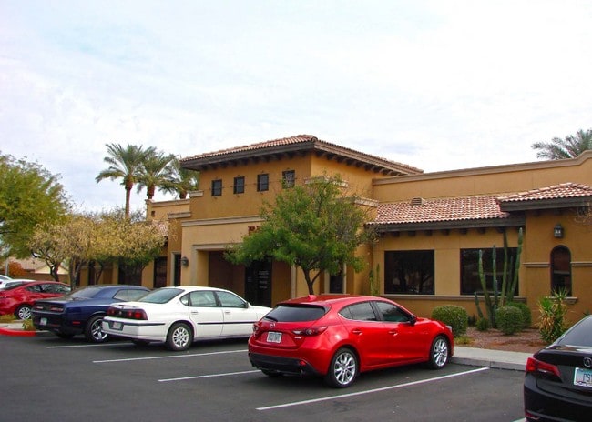


This Property Is For Sale
NEARBY LISTINGS FOR SALE OR LEASE
Property Detail
3400 N Dysart Rd
Phoenix-Mesa-Scottsdale, AZ
Coronado Professional Plaza 1St Amd
501-73-637
CORONADO PROFESSIONAL PLAZA 1ST AMD MCR 1014-24
Publicschool
Maricopa
X
Arizona
04013C2155M
119
0
0.06 AC
2025
West I-10
061021
Phoenix
5,661 SF
DEMOGRAPHICS near 3400 N Dysart Rd
1 Mile
3 Mile
5 Mile
2024 Total Population
14,854
95,009
214,947
2029 Population
16,021
103,230
235,154
Pop Growth 2024-2029
+ 7.86%
+ 8.65%
+ 9.40%
Average Age
37
38
37
2024 Total Households
5,020
31,928
70,360
HH Growth 2024-2029
+ 7.87%
+ 8.77%
+ 9.62%
Median Household Inc
$94,750
$87,985
$81,893
Avg Household Size
2.90
2.90
3.00
2024 Avg HH Vehicles
2.00
2.00
2.00
Median Home Value
$358,633
$377,756
$357,254
Median Year Built
2002
2002
2003
Nearby Places
Map Layers
Map Styles
 Street
 Aerial
- Restaurants
- Banks
- Shops
- Fitness
- Groceries
PUBLIC TRANSPORTATION
AIRPORT
Phoenix Sky Harbor International
DRIVE
WALK
Distance
Phoenix Sky Harbor International
32 min
23.7 mi
Nearby Properties
Address
Land Use
TOTAL SIZE
Lot Size
Zoning
Address
Land Use
TOTAL SIZE
Lot Size
Zoning
76,301 SF
15.91 AC
Address
Land Use
TOTAL SIZE
Lot Size
Zoning
Address
Land Use
TOTAL SIZE
Lot Size
Zoning
12.04 AC
Address
Land Use
TOTAL SIZE
Lot Size
Zoning
49,475 SF
5.70 AC
PAD
Address
Land Use
TOTAL SIZE
Lot Size
Zoning
370,726 SF
23.41 AC
PAD
Address
Land Use
TOTAL SIZE
Lot Size
Zoning
324,374 SF
18.26 AC
PAD
Address
Land Use
TOTAL SIZE
Lot Size
Zoning
2.51 AC
Address
Land Use
TOTAL SIZE
Lot Size
Zoning
401,714 SF
100.01 AC
PAD
Address
Land Use
TOTAL SIZE
Lot Size
Zoning
287,294 SF
67.46 AC
PAD
Address
Land Use
TOTAL SIZE
Lot Size
Zoning
296,791 SF
35 AC
PAD
Address
Land Use
TOTAL SIZE
Lot Size
Zoning
398,872 SF
9.39 AC
PAD
Address
Land Use
TOTAL SIZE
Lot Size
Zoning
295,014 SF
37.63 AC
PAD
Address
Land Use
TOTAL SIZE
Lot Size
Zoning
282,993 SF
14.16 AC
PF
Address
Land Use
TOTAL SIZE
Lot Size
Zoning
295,635 SF
16.57 AC
PAD
Address
Land Use
TOTAL SIZE
Lot Size
Zoning
293,849 SF
33.20 AC
PAD
Address
Land Use
TOTAL SIZE
Lot Size
Zoning
353,155 SF
16.80 AC
M-H
Address
Land Use
TOTAL SIZE
Lot Size
Zoning
340,061 SF
15.50 AC
M-H
Address
Land Use
TOTAL SIZE
Lot Size
Zoning
328,244 SF
18.44 AC
PAD
Address
Land Use
TOTAL SIZE
Lot Size
Zoning
106,351 SF
20 AC
PAD
Address
Land Use
TOTAL SIZE
Lot Size
Zoning
189,996 SF
8.80 AC
PAD
Address
Land Use
TOTAL SIZE
Lot Size
Zoning
6,472 SF
1.14 AC
PAD
Address
Land Use
TOTAL SIZE
Lot Size
Zoning
116,236 SF
12.68 AC
PAD
Address
Land Use
TOTAL SIZE
Lot Size
Zoning
109,856 SF
25.18 AC
R-43
Address
Land Use
TOTAL SIZE
Lot Size
Zoning
232,797 SF
25.43 AC
PAD
Address
Land Use
TOTAL SIZE
Lot Size
Zoning
102,431 SF
17.63 AC
R-10
Address
Land Use
TOTAL SIZE
Lot Size
Zoning
291,805 SF
16.48 AC
PAD
Address
Land Use
TOTAL SIZE
Lot Size
Zoning
181,897 SF
16.71 AC
R-43AG
Address
Land Use
TOTAL SIZE
Lot Size
Zoning
130,610 SF
3.35 AC
PAD
Address
Land Use
TOTAL SIZE
Lot Size
Zoning
120,289 SF
13.69 AC
C-S
Address
Land Use
TOTAL SIZE
Lot Size
Zoning
291,119 SF
15.38 AC
PAD
The World's #1 Commercial Real Estate Marketplace
Connect with us
© 2025 CoStar Group
The information above has been obtained from sources believed reliable. While we do not doubt its accuracy we have not verified it and make no guarantee, warranty or representation about it. It is your responsibility to independently confirm its accuracy and completeness. Any projections, opinions, assumptions, or estimates used are for example only and do not represent the current or future performance of the property. The value of this transaction to you depends on tax and other factors which should be evaluated by your tax, financial, and legal advisors. You and your advisors should conduct a careful, independent investigation of the property to determine to your satisfaction the suitability of the property for your needs.