Property Record
3400 S Macarthur Dr, Alexandria, LA 71302
NEARBY LISTINGS FOR SALE OR LEASE
-
-
View all Alexandria listings for sale on LoopNet.com
Property Detail
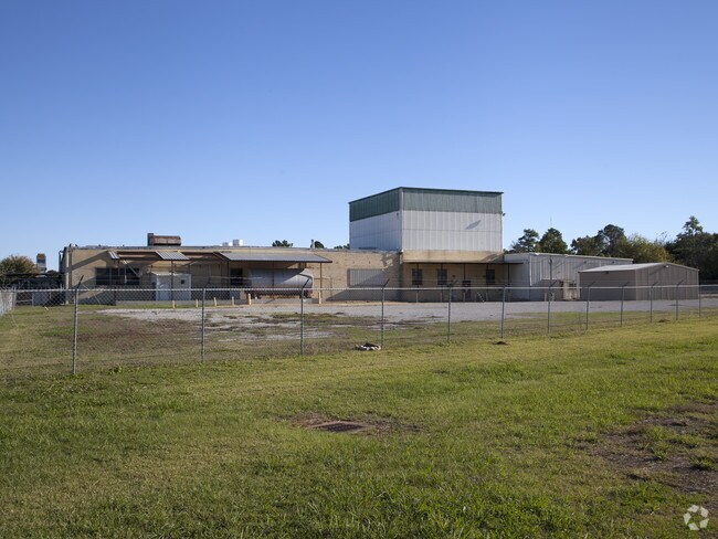
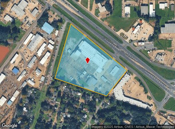
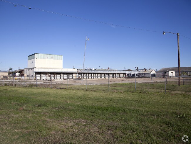
3400 S Macarthur Dr
Other Market Areas
Macarthur Drive
Alexandria, LA
8.379 ACS: FRTG 840' ON MACARTHUR DRIVE; IN SECS 46 & 47 T3NR1W (CB 355-308 BLALOCK)(CB 365-360 DIFULCO)(CB 1342-490 REDEMPTI
23-046-33029-0001
Rapides
Industrialgeneral
Louisiana
2024
9 AC
2024
Louisiana North Area
012500
DEMOGRAPHICS near 3400 S Macarthur Dr
1 Mile
3 Mile
5 Mile
2024 Total Population
5,882
36,212
55,482
2029 Population
5,778
35,457
54,470
Pop Growth 2024-2029
(1.77%)
(2.08%)
(1.82%)
Average Age
39
40
39
2024 Total Households
2,334
14,843
22,347
HH Growth 2024-2029
(1.71%)
(2.08%)
(1.83%)
Median Household Inc
$38,201
$41,132
$38,952
Avg Household Size
2.40
2.30
2.30
2024 Avg HH Vehicles
2.00
1.00
1.00
Median Home Value
$142,786
$163,836
$160,502
Median Year Built
1973
1969
1971
Nearby Places
Map Layers
Map Styles
 Street
 Aerial
- Restaurants
- Banks
- Shops
- Fitness
- Groceries
PUBLIC TRANSPORTATION
AIRPORT
Alexandria International
DRIVE
WALK
Distance
Alexandria International
23 min
10.3 mi
Nearby Properties
Address
Land Use
TOTAL SIZE
Lot Size
Zoning
Address
Land Use
TOTAL SIZE
Lot Size
Zoning
Address
Land Use
TOTAL SIZE
Lot Size
Zoning
Address
Land Use
TOTAL SIZE
Lot Size
Zoning
Address
Land Use
TOTAL SIZE
Lot Size
Zoning
Address
Land Use
TOTAL SIZE
Lot Size
Zoning
Address
Land Use
TOTAL SIZE
Lot Size
Zoning
Address
Land Use
TOTAL SIZE
Lot Size
Zoning
Address
Land Use
TOTAL SIZE
Lot Size
Zoning
54,135 SF
7 AC
Address
Land Use
TOTAL SIZE
Lot Size
Zoning
Address
Land Use
TOTAL SIZE
Lot Size
Zoning
59,500 SF
2.23 AC
Address
Land Use
TOTAL SIZE
Lot Size
Zoning
Address
Land Use
TOTAL SIZE
Lot Size
Zoning
10.27 AC
Address
Land Use
TOTAL SIZE
Lot Size
Zoning
Address
Land Use
TOTAL SIZE
Lot Size
Zoning
Address
Land Use
TOTAL SIZE
Lot Size
Zoning
57,867 SF
1.80 AC
Address
Land Use
TOTAL SIZE
Lot Size
Zoning
Address
Land Use
TOTAL SIZE
Lot Size
Zoning
318,655 SF
19.14 AC
Address
Land Use
TOTAL SIZE
Lot Size
Zoning
100,959 SF
9 AC
Address
Land Use
TOTAL SIZE
Lot Size
Zoning
Address
Land Use
TOTAL SIZE
Lot Size
Zoning
4.13 AC
Address
Land Use
TOTAL SIZE
Lot Size
Zoning
Address
Land Use
TOTAL SIZE
Lot Size
Zoning
Address
Land Use
TOTAL SIZE
Lot Size
Zoning
Address
Land Use
TOTAL SIZE
Lot Size
Zoning
Address
Land Use
TOTAL SIZE
Lot Size
Zoning
Address
Land Use
TOTAL SIZE
Lot Size
Zoning
Address
Land Use
TOTAL SIZE
Lot Size
Zoning
42,196 SF
5.47 AC
Address
Land Use
TOTAL SIZE
Lot Size
Zoning
Address
Land Use
TOTAL SIZE
Lot Size
Zoning
4.88 AC
The World's #1 Commercial Real Estate Marketplace
Connect with us
© 2025 CoStar Group
The information above has been obtained from sources believed reliable. While we do not doubt its accuracy we have not verified it and make no guarantee, warranty or representation about it. It is your responsibility to independently confirm its accuracy and completeness. Any projections, opinions, assumptions, or estimates used are for example only and do not represent the current or future performance of the property. The value of this transaction to you depends on tax and other factors which should be evaluated by your tax, financial, and legal advisors. You and your advisors should conduct a careful, independent investigation of the property to determine to your satisfaction the suitability of the property for your needs.