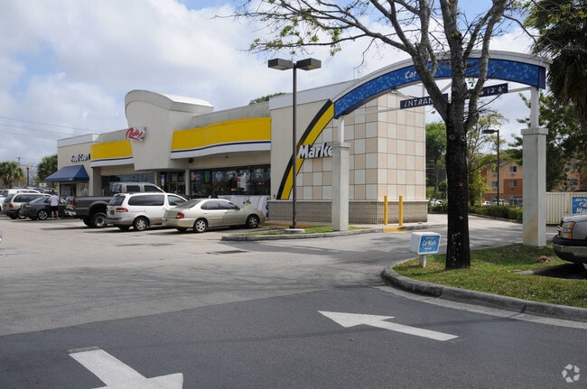
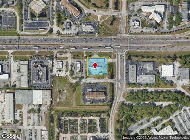
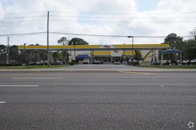
Property Record
3400 Ulmerton Rd, Clearwater, FL 33762

NEARBY LISTINGS FOR SALE OR LEASE
Property Detail
3400 Ulmerton Rd
Tampa-St. Petersburg-Clearwater, FL
Pinellas Groves
10-30-16-71010-100-0101
PINELLAS GROVES NE 1/4, PT OF LOT 1 DESC FROM NE SEC COR TH S 110FT TH N89DW 50FT FOR POB TH S 211.79FT TH N89DW 230FT TH N 209.61FT TH S89DE 229FT (S) TO POB CONT 1.1AC(C)
Storebuilding
Pinellas
AE
Florida
12103C0143H
1
2024
1.10 AC
2025
Gateway
024512
Tampa/St Petersburg
4,888 SF
DEMOGRAPHICS near 3400 Ulmerton Rd
1 Mile
3 Mile
5 Mile
2024 Total Population
1,700
38,530
163,425
2029 Population
1,694
38,678
164,694
Pop Growth 2024-2029
(0.35%)
+ 0.38%
+ 0.78%
Average Age
44
43
44
2024 Total Households
867
18,632
76,555
HH Growth 2024-2029
(0.58%)
+ 0.12%
+ 0.72%
Median Household Inc
$90,833
$61,102
$57,495
Avg Household Size
1.90
2.00
2.00
2024 Avg HH Vehicles
2.00
1.00
2.00
Median Home Value
$376,811
$235,341
$215,694
Median Year Built
1983
1983
1979
Nearby Places
Map Layers
Map Styles
 Street
 Aerial
- Restaurants
- Banks
- Shops
- Fitness
- Groceries
PUBLIC TRANSPORTATION
AIRPORT
St Pete-Clearwater International
DRIVE
WALK
Distance
St Pete-Clearwater International
10 min
2.4 mi
Tampa International
DRIVE
WALK
Distance
Tampa International
22 min
13.0 mi
Nearby Properties
Address
Land Use
TOTAL SIZE
Lot Size
Zoning
Address
Land Use
TOTAL SIZE
Lot Size
Zoning
795,890 SF
69.11 AC
M1
Address
Land Use
TOTAL SIZE
Lot Size
Zoning
130,544 SF
1,313.50 AC
PCAIRPOR
Address
Land Use
TOTAL SIZE
Lot Size
Zoning
1,160,631 SF
28.08 AC
Address
Land Use
TOTAL SIZE
Lot Size
Zoning
1,232,878 SF
12.64 AC
Address
Land Use
TOTAL SIZE
Lot Size
Zoning
551,317 SF
52.55 AC
Address
Land Use
TOTAL SIZE
Lot Size
Zoning
749,164 SF
7.11 AC
Address
Land Use
TOTAL SIZE
Lot Size
Zoning
428,587 SF
14.35 AC
Address
Land Use
TOTAL SIZE
Lot Size
Zoning
372,013 SF
10.10 AC
Address
Land Use
TOTAL SIZE
Lot Size
Zoning
484,229 SF
28 AC
Address
Land Use
TOTAL SIZE
Lot Size
Zoning
466,420 SF
2.60 AC
Address
Land Use
TOTAL SIZE
Lot Size
Zoning
447,664 SF
34.44 AC
Address
Land Use
TOTAL SIZE
Lot Size
Zoning
171,420 SF
300.24 AC
M1
Address
Land Use
TOTAL SIZE
Lot Size
Zoning
350,604 SF
13.21 AC
Address
Land Use
TOTAL SIZE
Lot Size
Zoning
429,226 SF
0.85 AC
Address
Land Use
TOTAL SIZE
Lot Size
Zoning
416,482 SF
14.93 AC
Address
Land Use
TOTAL SIZE
Lot Size
Zoning
346,420 SF
17.95 AC
Address
Land Use
TOTAL SIZE
Lot Size
Zoning
401,627 SF
0.66 AC
Address
Land Use
TOTAL SIZE
Lot Size
Zoning
358,681 SF
11.70 AC
Address
Land Use
TOTAL SIZE
Lot Size
Zoning
308,107 SF
32.37 AC
Address
Land Use
TOTAL SIZE
Lot Size
Zoning
240,736 SF
58.40 AC
Address
Land Use
TOTAL SIZE
Lot Size
Zoning
402,681 SF
18.40 AC
Address
Land Use
TOTAL SIZE
Lot Size
Zoning
255,548 SF
21.69 AC
RPD10
Address
Land Use
TOTAL SIZE
Lot Size
Zoning
364,675 SF
66.40 AC
AE
Address
Land Use
TOTAL SIZE
Lot Size
Zoning
243,101 SF
24.86 AC
Address
Land Use
TOTAL SIZE
Lot Size
Zoning
311,000 SF
15.50 AC
Address
Land Use
TOTAL SIZE
Lot Size
Zoning
446,556 SF
14.95 AC
M1
Address
Land Use
TOTAL SIZE
Lot Size
Zoning
396,822 SF
36.20 AC
RPD5
Address
Land Use
TOTAL SIZE
Lot Size
Zoning
249,361 SF
20.79 AC
Address
Land Use
TOTAL SIZE
Lot Size
Zoning
362,618 SF
40.19 AC
R6
Address
Land Use
TOTAL SIZE
Lot Size
Zoning
266,396 SF
23.18 AC
The World's #1 Commercial Real Estate Marketplace
Connect with us
© 2025 CoStar Group
The information above has been obtained from sources believed reliable. While we do not doubt its accuracy we have not verified it and make no guarantee, warranty or representation about it. It is your responsibility to independently confirm its accuracy and completeness. Any projections, opinions, assumptions, or estimates used are for example only and do not represent the current or future performance of the property. The value of this transaction to you depends on tax and other factors which should be evaluated by your tax, financial, and legal advisors. You and your advisors should conduct a careful, independent investigation of the property to determine to your satisfaction the suitability of the property for your needs.