Property Record
3401 David Shor Rd, Brownsville, TX 78521


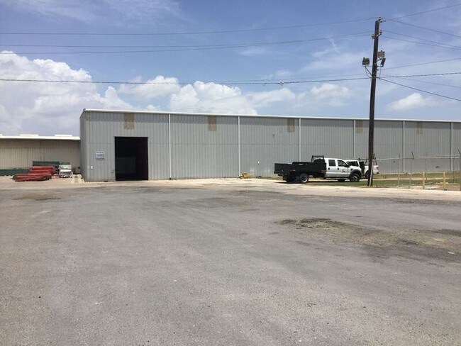
Property Detail
3401 David Shor Rd
Brownsville-Harlingen, TX
EL JARDIN RESUBDIVISION LOT 1 BLK 413 BRO NAV DIST LEASE # 2216 (BLDG ON LEASED LAND)
747540-4130-002000
Cameron
Industrialgeneral
Texas
C and X Area of minimal flood hazard, usually depicted on FIRMs as above the 500-year flood level.
1
2024
13.84 AC
2025
Outlying Cameron County
012700
Brownsville/Harlingen
62,840 SF
NEARBY LISTINGS FOR SALE OR LEASE
-
-
View all Brownsville listings for sale on LoopNet.com
DEMOGRAPHICS near 3401 David Shor Rd
1 mile
3 mile
5 mile
2025 Total Population
3,574
31,285
88,816
2030 Population
3,626
32,353
90,921
Pop Growth 2025-2030
+ 1.45%
+ 3.41%
+ 2.37%
Average Age
33
34
35
2025 Total Households
872
8,833
26,278
HH Growth 2025-2030
+ 1.49%
+ 3.62%
+ 2.52%
Median Household Inc
$50,658
$46,533
$47,779
Avg Household Size
3.80
3.50
3.30
2025 Avg HH Vehicles
2.00
2.00
2.00
Median Home Value
$93,067
$122,126
$131,461
Median Year Built
1998
1998
1996
Nearby Places
Map Layers
Map Styles
 Street
 Aerial
Layers
 Traffic
 Biking
Places
Listings with unknown addresses are not visible on the map
- Restaurants
- Banks
- Shops
- Fitness
- Groceries
PUBLIC TRANSPORTATION
AIRPORT
Brownsville/South Padre Island International
Drive
Walk
Distance
Brownsville/South Padre Island International
11 min
5.2 mi
Valley International
Drive
Walk
Distance
Valley International
37 min
28.6 mi
Freight Ports
Port of Brownsville
Drive
Walk
Distance
Port of Brownsville
2 min
0.9 mi
Nearby Properties
Address
Land Use
TOTAL SIZE
Lot Size
Zoning
Address
Land Use
TOTAL SIZE
Lot Size
Zoning
167,737 SF
29.87 AC
Address
Land Use
TOTAL SIZE
Lot Size
Zoning
286,243 SF
19.21 AC
C
Address
Land Use
TOTAL SIZE
Lot Size
Zoning
145,240 SF
17.49 AC
Address
Land Use
TOTAL SIZE
Lot Size
Zoning
115,463 SF
22.09 AC
Address
Land Use
TOTAL SIZE
Lot Size
Zoning
88,591 SF
22 AC
SD6
Address
Land Use
TOTAL SIZE
Lot Size
Zoning
120,166 SF
12.33 AC
Address
Land Use
TOTAL SIZE
Lot Size
Zoning
112,263 SF
9.66 AC
Address
Land Use
TOTAL SIZE
Lot Size
Zoning
98,740 SF
15.56 AC
Address
Land Use
TOTAL SIZE
Lot Size
Zoning
238,221 SF
27.02 AC
Address
Land Use
TOTAL SIZE
Lot Size
Zoning
88,256 SF
18.16 AC
Address
Land Use
TOTAL SIZE
Lot Size
Zoning
137,228 SF
18.43 AC
A-U
Address
Land Use
TOTAL SIZE
Lot Size
Zoning
0.17 AC
Address
Land Use
TOTAL SIZE
Lot Size
Zoning
48,760 SF
7 AC
C
Address
Land Use
TOTAL SIZE
Lot Size
Zoning
82,300 SF
3.20 AC
I
Address
Land Use
TOTAL SIZE
Lot Size
Zoning
102,432 SF
5.27 AC
C
Address
Land Use
TOTAL SIZE
Lot Size
Zoning
100,000 SF
7.93 AC
I
Address
Land Use
TOTAL SIZE
Lot Size
Zoning
100,000 SF
7.79 AC
I
Address
Land Use
TOTAL SIZE
Lot Size
Zoning
100,000 SF
5.20 AC
I
Address
Land Use
TOTAL SIZE
Lot Size
Zoning
104,000 SF
15.12 AC
I
Address
Land Use
TOTAL SIZE
Lot Size
Zoning
101,581 SF
4.14 AC
Address
Land Use
TOTAL SIZE
Lot Size
Zoning
101,189 SF
10 AC
C
Address
Land Use
TOTAL SIZE
Lot Size
Zoning
88,220 SF
11 AC
C
Address
Land Use
TOTAL SIZE
Lot Size
Zoning
64,545 SF
4.42 AC
Address
Land Use
TOTAL SIZE
Lot Size
Zoning
107,200 SF
8.53 AC
C
Address
Land Use
TOTAL SIZE
Lot Size
Zoning
100,000 SF
11.34 AC
I
Address
Land Use
TOTAL SIZE
Lot Size
Zoning
23,154 SF
2.40 AC
C
Address
Land Use
TOTAL SIZE
Lot Size
Zoning
86,200 SF
10 AC
Address
Land Use
TOTAL SIZE
Lot Size
Zoning
210,741 SF
20.06 AC
Address
Land Use
TOTAL SIZE
Lot Size
Zoning
111,736 SF
13.59 AC
Address
Land Use
TOTAL SIZE
Lot Size
Zoning
8,527 SF
13.02 AC
The World's #1 Commercial Real Estate Marketplace
Connect with us
© 2026 CoStar Group
The information above has been obtained from sources believed reliable. While we do not doubt its accuracy we have not verified it and make no guarantee, warranty or representation about it. It is your responsibility to independently confirm its accuracy and completeness. Any projections, opinions, assumptions, or estimates used are for example only and do not represent the current or future performance of the property. The value of this transaction to you depends on tax and other factors which should be evaluated by your tax, financial, and legal advisors. You and your advisors should conduct a careful, independent investigation of the property to determine to your satisfaction the suitability of the property for your needs.