Property Record
3401 E 4Th Ave, Hutchinson, KS 67501


Save to a Folder
{{folder.Name}}
{{folder.ListingIds.length}} Properties
{{folder.ListingIds.length}} Property
Create a New Folder
This Property Is For Sale
Property Detail
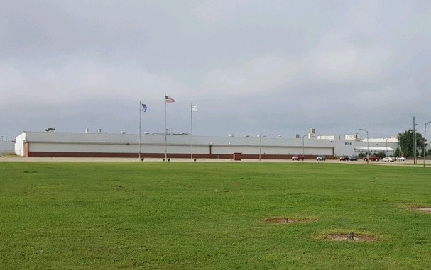
3401 E 4Th Ave
Hutchinson, KS
EATON, S16, T23, R05W, LOT 4 BLK 1 EXC N 466.68 FT OF W 455.93 FT
135-16-0-10-01-002.00
Reno
Officebuilding
Kansas
B and X Area of moderate flood hazard, usually the area between the limits of the 100-year and 500-year floods.
4
2025
33.45 AC
2025
Kansas Area
001100
Other Market Areas
347,288 SF
NEARBY LISTINGS FOR SALE OR LEASE
DEMOGRAPHICS near 3401 E 4Th Ave
1 mile
3 mile
5 mile
2025 Total Population
527
16,094
41,999
2030 Population
531
16,115
41,877
Pop Growth 2025-2030
+ 0.76%
+ 0.13%
(0.29%)
Average Age
45
41
41
2025 Total Households
148
6,649
17,796
HH Growth 2025-2030
+ 0.68%
+ 0.14%
(0.30%)
Median Household Inc
$70,227
$55,740
$56,889
Avg Household Size
2.30
2.20
2.20
2025 Avg HH Vehicles
3.00
2.00
2.00
Median Home Value
$149,285
$99,202
$130,450
Median Year Built
1959
1962
1959
Nearby Places
Map Layers
Map Styles
 Street
 Aerial
Layers
 Traffic
 Biking
Places
Listings with unknown addresses are not visible on the map
- Restaurants
- Banks
- Shops
- Fitness
- Groceries
PUBLIC TRANSPORTATION
COMMUTER RAIL
Hutchinson Amtrak Station (Southwest Chief - Amtrak)
Drive
Walk
Distance
Hutchinson Amtrak Station (Southwest Chief - Amtrak)
9 min
3.6 mi
Freight Ports
Tulsa Port Of Catoosa
Drive
Walk
Distance
Tulsa Port Of Catoosa
260 min
240.0 mi
Nearby Properties
Address
Land Use
TOTAL SIZE
Lot Size
Zoning
Address
Land Use
TOTAL SIZE
Lot Size
Zoning
279,450 SF
11 AC
P
Address
Land Use
TOTAL SIZE
Lot Size
Zoning
94,825 SF
10 AC
Address
Land Use
TOTAL SIZE
Lot Size
Zoning
13,170 SF
36.34 AC
PI
Address
Land Use
TOTAL SIZE
Lot Size
Zoning
77,674 SF
44.42 AC
P
Address
Land Use
TOTAL SIZE
Lot Size
Zoning
59.65 AC
P
Address
Land Use
TOTAL SIZE
Lot Size
Zoning
54,149 SF
9.27 AC
Address
Land Use
TOTAL SIZE
Lot Size
Zoning
60,073 SF
4.58 AC
P
Address
Land Use
TOTAL SIZE
Lot Size
Zoning
13,759 SF
629.53 AC
Address
Land Use
TOTAL SIZE
Lot Size
Zoning
276,078 SF
102.35 AC
I3
Address
Land Use
TOTAL SIZE
Lot Size
Zoning
121,446 SF
14.69 AC
PI
Address
Land Use
TOTAL SIZE
Lot Size
Zoning
89,642 SF
19.83 AC
C1
Address
Land Use
TOTAL SIZE
Lot Size
Zoning
128,121 SF
25.83 AC
Address
Land Use
TOTAL SIZE
Lot Size
Zoning
64,802 SF
14.07 AC
P
Address
Land Use
TOTAL SIZE
Lot Size
Zoning
35,136 SF
3.86 AC
Address
Land Use
TOTAL SIZE
Lot Size
Zoning
1,320 SF
5.94 AC
Address
Land Use
TOTAL SIZE
Lot Size
Zoning
23,394 SF
35.24 AC
Address
Land Use
TOTAL SIZE
Lot Size
Zoning
69,395 SF
17.62 AC
P
Address
Land Use
TOTAL SIZE
Lot Size
Zoning
47,545 SF
15.60 AC
CR
Address
Land Use
TOTAL SIZE
Lot Size
Zoning
18,200 SF
3.46 AC
Address
Land Use
TOTAL SIZE
Lot Size
Zoning
20,356 SF
Address
Land Use
TOTAL SIZE
Lot Size
Zoning
57,600 SF
22.43 AC
I3
Address
Land Use
TOTAL SIZE
Lot Size
Zoning
196,881 SF
27.83 AC
C4
Address
Land Use
TOTAL SIZE
Lot Size
Zoning
33,881 SF
6.23 AC
Address
Land Use
TOTAL SIZE
Lot Size
Zoning
50,000 SF
7.79 AC
I3
Address
Land Use
TOTAL SIZE
Lot Size
Zoning
10,849 SF
7.55 AC
C4
Address
Land Use
TOTAL SIZE
Lot Size
Zoning
46,690 SF
5.23 AC
C1
Address
Land Use
TOTAL SIZE
Lot Size
Zoning
151.45 AC
Address
Land Use
TOTAL SIZE
Lot Size
Zoning
118,171 SF
29.15 AC
C4
Address
Land Use
TOTAL SIZE
Lot Size
Zoning
95,252 SF
4.05 AC
Address
Land Use
TOTAL SIZE
Lot Size
Zoning
20,924 SF
3.01 AC
PI
The World's #1 Commercial Real Estate Marketplace
Connect with us
© 2026 CoStar Group
The information above has been obtained from sources believed reliable. While we do not doubt its accuracy we have not verified it and make no guarantee, warranty or representation about it. It is your responsibility to independently confirm its accuracy and completeness. Any projections, opinions, assumptions, or estimates used are for example only and do not represent the current or future performance of the property. The value of this transaction to you depends on tax and other factors which should be evaluated by your tax, financial, and legal advisors. You and your advisors should conduct a careful, independent investigation of the property to determine to your satisfaction the suitability of the property for your needs.