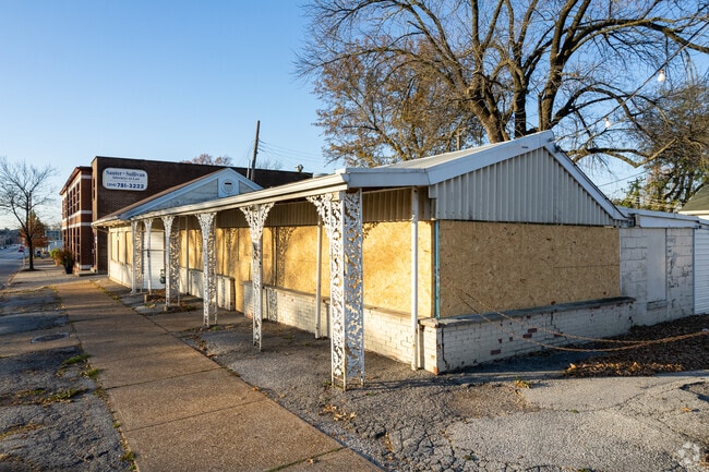
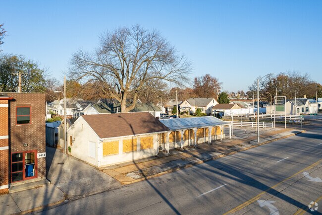
Property Record
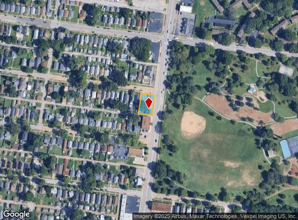
3401 Hampton Ave, Saint Louis, MO 63139
NEARBY LISTINGS FOR SALE OR LEASE
Property Detail
3401 Hampton Ave
St. Louis, MO-IL
Fyler Place Addn
4763-28-0180-0
CB 4763BW HAMPTON AV 124FT 11 1/2IN X 84FT 8 3/4IN/84FT 10 5/8IN FYLER PLACE ADDN LOTS 19-20-21
Commercialnec
St. Louis City
X
Missouri
29189C0331K
19
2024
0.24 AC
2025
St Louis City South
114200
St. Louis
2,555 SF
DEMOGRAPHICS near 3401 Hampton Ave
1 Mile
3 Mile
5 Mile
2024 Total Population
17,753
136,383
359,184
2029 Population
16,192
127,691
343,031
Pop Growth 2024-2029
(8.79%)
(6.37%)
(4.50%)
Average Age
42
40
39
2024 Total Households
9,262
67,163
166,905
HH Growth 2024-2029
(8.64%)
(6.41%)
(4.69%)
Median Household Inc
$68,045
$63,985
$63,033
Avg Household Size
1.90
2.00
2.00
2024 Avg HH Vehicles
2.00
1.00
1.00
Median Home Value
$193,839
$210,948
$228,423
Median Year Built
1947
1947
1948
Nearby Places
Map Layers
Map Styles
 Street
 Aerial
- Restaurants
- Banks
- Shops
- Fitness
- Groceries
PUBLIC TRANSPORTATION
COMMUTER RAIL
Shrewsbury-Lansdowne (Shrewsbury-Lansdowne I-44 Emerson Park - St. Louis MetroLink (MetroLink))
DRIVE
WALK
Distance
Shrewsbury-Lansdowne (Shrewsbury-Lansdowne I-44 Emerson Park - St. Louis MetroLink (MetroLink))
4 min
2.1 mi
Sunnen (Shrewsbury-Lansdowne I-44 Emerson Park - St. Louis MetroLink (MetroLink))
DRIVE
WALK
Distance
Sunnen (Shrewsbury-Lansdowne I-44 Emerson Park - St. Louis MetroLink (MetroLink))
8 min
3.8 mi
AIRPORT
St Louis Lambert International
DRIVE
WALK
Distance
St Louis Lambert International
23 min
15.5 mi
Scott AFB/Midamerica St Louis
DRIVE
WALK
Distance
Scott AFB/Midamerica St Louis
48 min
32.0 mi
Freight Ports
Port Milwaukee
DRIVE
WALK
Distance
Port Milwaukee
427 min
376.3 mi
SALE & LEASE HISTORY
LISTING DATE
SALE/LEASE

Jun 06, 2022
For Sale
Nearby Properties
Address
Land Use
TOTAL SIZE
Lot Size
Zoning
Address
Land Use
TOTAL SIZE
Lot Size
Zoning
0.92 AC
A
Address
Land Use
TOTAL SIZE
Lot Size
Zoning
5.61 AC
A
Address
Land Use
TOTAL SIZE
Lot Size
Zoning
136.92 AC
AI
Address
Land Use
TOTAL SIZE
Lot Size
Zoning
833,982 SF
18.70 AC
GB
Address
Land Use
TOTAL SIZE
Lot Size
Zoning
52,556 SF
68.80 AC
14R-2
Address
Land Use
TOTAL SIZE
Lot Size
Zoning
229.57 AC
B
Address
Land Use
TOTAL SIZE
Lot Size
Zoning
57.77 AC
A
Address
Land Use
TOTAL SIZE
Lot Size
Zoning
6.05 AC
J
Address
Land Use
TOTAL SIZE
Lot Size
Zoning
306,459 SF
4.79 AC
H
Address
Land Use
TOTAL SIZE
Lot Size
Zoning
358,243 SF
3.02 AC
H
Address
Land Use
TOTAL SIZE
Lot Size
Zoning
309,734 SF
3.41 AC
E
Address
Land Use
TOTAL SIZE
Lot Size
Zoning
559,752 SF
24.37 AC
53R-3
Address
Land Use
TOTAL SIZE
Lot Size
Zoning
117,270 SF
0.21 AC
49C2
Address
Land Use
TOTAL SIZE
Lot Size
Zoning
212,406 SF
21.42 AC
AB
Address
Land Use
TOTAL SIZE
Lot Size
Zoning
198,556 SF
10.12 AC
A
Address
Land Use
TOTAL SIZE
Lot Size
Zoning
44.38 AC
R1
Address
Land Use
TOTAL SIZE
Lot Size
Zoning
158,767 SF
17.01 AC
64A3
Address
Land Use
TOTAL SIZE
Lot Size
Zoning
39,712 SF
30.49 AC
R1
Address
Land Use
TOTAL SIZE
Lot Size
Zoning
2,375 SF
8.19 AC
14R-5
Address
Land Use
TOTAL SIZE
Lot Size
Zoning
3,024 SF
4.73 AC
64A3
Address
Land Use
TOTAL SIZE
Lot Size
Zoning
22.44 AC
A
Address
Land Use
TOTAL SIZE
Lot Size
Zoning
432,844 SF
5.08 AC
JK
Address
Land Use
TOTAL SIZE
Lot Size
Zoning
220,982 SF
2.83 AC
HB
Address
Land Use
TOTAL SIZE
Lot Size
Zoning
256,565 SF
3.70 AC
G
Address
Land Use
TOTAL SIZE
Lot Size
Zoning
227,634 SF
11.28 AC
49C2
Address
Land Use
TOTAL SIZE
Lot Size
Zoning
206,280 SF
2.85 AC
9PD
Address
Land Use
TOTAL SIZE
Lot Size
Zoning
48,236 SF
16.23 AC
64A1
Address
Land Use
TOTAL SIZE
Lot Size
Zoning
39,863 SF
5.83 AC
H
Address
Land Use
TOTAL SIZE
Lot Size
Zoning
1,176 SF
11.19 AC
64A3
Address
Land Use
TOTAL SIZE
Lot Size
Zoning
23.21 AC
A
The World's #1 Commercial Real Estate Marketplace
Connect with us
© 2025 CoStar Group
The information above has been obtained from sources believed reliable. While we do not doubt its accuracy we have not verified it and make no guarantee, warranty or representation about it. It is your responsibility to independently confirm its accuracy and completeness. Any projections, opinions, assumptions, or estimates used are for example only and do not represent the current or future performance of the property. The value of this transaction to you depends on tax and other factors which should be evaluated by your tax, financial, and legal advisors. You and your advisors should conduct a careful, independent investigation of the property to determine to your satisfaction the suitability of the property for your needs.