Property Record
3401 Kienlen Ave, Saint Louis, MO 63121

Save to a Folder
{{folder.Name}}
{{folder.ListingIds.length}} Properties
{{folder.ListingIds.length}} Property
Create a New Folder
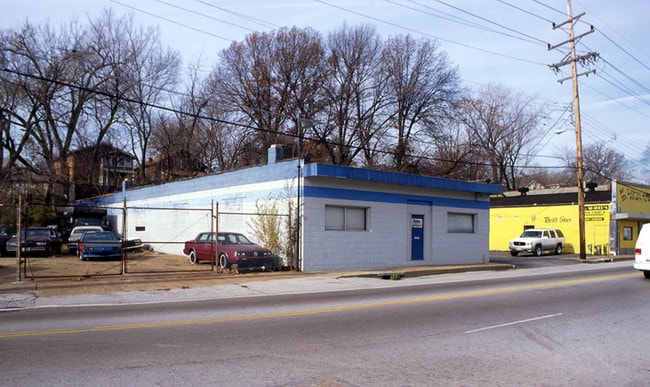
Property Detail
3401 Kienlen Ave
15G-11-2098
NATURAL PARK LOT PTS 15 & 16
Warehouse
ST. LOUIS
48E
Missouri
B and X Area of moderate flood hazard, usually the area between the limits of the 100-year and 500-year floods.
15,16
0
0.11 AC
2025
Innerbelt E of 170
212300
St. Louis
4,251 SF
St. Louis, MO-IL
NEARBY LISTINGS FOR SALE OR LEASE
DEMOGRAPHICS near 3401 Kienlen Ave
1 mile
3 mile
5 mile
2025 Total Population
15,119
124,346
299,535
2030 Population
15,702
125,660
300,016
Pop Growth 2025-2030
+ 3.86%
+ 1.06%
+ 0.16%
Average Age
40
40
40
2025 Total Households
6,004
53,801
130,228
HH Growth 2025-2030
+ 3.65%
+ 0.68%
(0.28%)
Median Household Inc
$35,452
$43,214
$51,771
Avg Household Size
2.40
2.20
2.10
2025 Avg HH Vehicles
1.00
1.00
1.00
Median Home Value
$56,420
$90,471
$135,366
Median Year Built
1949
1948
1951
Nearby Places
Map Layers
Map Styles
 Street
 Aerial
Layers
 Traffic
 Biking
Places
Listings with unknown addresses are not visible on the map
- Restaurants
- Banks
- Shops
- Fitness
- Groceries
PUBLIC TRANSPORTATION
COMMUTER RAIL
Wellston (Lambert Airport Shiloh-Scott - St. Louis MetroLink (MetroLink))
Drive
Walk
Distance
Wellston (Lambert Airport Shiloh-Scott - St. Louis MetroLink (MetroLink))
4 min
2.0 mi
UM St. Louis South (Lambert Airport Shiloh-Scott - St. Louis MetroLink (MetroLink))
Drive
Walk
Distance
UM St. Louis South (Lambert Airport Shiloh-Scott - St. Louis MetroLink (MetroLink))
4 min
2.2 mi
AIRPORT
St Louis Lambert International
Drive
Walk
Distance
St Louis Lambert International
12 min
6.9 mi
Scott AFB/Midamerica St Louis
Drive
Walk
Distance
Scott AFB/Midamerica St Louis
48 min
31.4 mi
Nearby Properties
Address
Land Use
TOTAL SIZE
Lot Size
Zoning
Address
Land Use
TOTAL SIZE
Lot Size
Zoning
Address
Land Use
TOTAL SIZE
Lot Size
Zoning
124.96 AC
J
Address
Land Use
TOTAL SIZE
Lot Size
Zoning
152.07 AC
L
Address
Land Use
TOTAL SIZE
Lot Size
Zoning
72,612 SF
118.34 AC
3INSTU
Address
Land Use
TOTAL SIZE
Lot Size
Zoning
7.94 AC
D
Address
Land Use
TOTAL SIZE
Lot Size
Zoning
348,233 SF
23.68 AC
Address
Land Use
TOTAL SIZE
Lot Size
Zoning
231,336 SF
18.88 AC
7M-2
Address
Land Use
TOTAL SIZE
Lot Size
Zoning
101,200 SF
1.10 AC
E
Address
Land Use
TOTAL SIZE
Lot Size
Zoning
46.18 AC
A
Address
Land Use
TOTAL SIZE
Lot Size
Zoning
121,418 SF
1.28 AC
H
Address
Land Use
TOTAL SIZE
Lot Size
Zoning
18.32 AC
PA
Address
Land Use
TOTAL SIZE
Lot Size
Zoning
151,640 SF
5.38 AC
D
Address
Land Use
TOTAL SIZE
Lot Size
Zoning
0.73 AC
B
Address
Land Use
TOTAL SIZE
Lot Size
Zoning
5,640 SF
10.42 AC
A
Address
Land Use
TOTAL SIZE
Lot Size
Zoning
223,395 SF
1.41 AC
H
Address
Land Use
TOTAL SIZE
Lot Size
Zoning
167,174 SF
1.23 AC
E
Address
Land Use
TOTAL SIZE
Lot Size
Zoning
19.94 AC
39SFR
Address
Land Use
TOTAL SIZE
Lot Size
Zoning
15,149 SF
120.85 AC
A
Address
Land Use
TOTAL SIZE
Lot Size
Zoning
51,460 SF
101.96 AC
K
Address
Land Use
TOTAL SIZE
Lot Size
Zoning
3.79 AC
PA
Address
Land Use
TOTAL SIZE
Lot Size
Zoning
229.57 AC
A
Address
Land Use
TOTAL SIZE
Lot Size
Zoning
148,683 SF
2.58 AC
57HDR
Address
Land Use
TOTAL SIZE
Lot Size
Zoning
27.96 AC
NU
Address
Land Use
TOTAL SIZE
Lot Size
Zoning
675 SF
20.38 AC
R5
Address
Land Use
TOTAL SIZE
Lot Size
Zoning
448,714 SF
34.05 AC
22M-1
Address
Land Use
TOTAL SIZE
Lot Size
Zoning
30.99 AC
39MULTI
Address
Land Use
TOTAL SIZE
Lot Size
Zoning
137,805 SF
0.85 AC
H
Address
Land Use
TOTAL SIZE
Lot Size
Zoning
108,753 SF
18.44 AC
31C-3
Address
Land Use
TOTAL SIZE
Lot Size
Zoning
210,844 SF
1.37 AC
E
Address
Land Use
TOTAL SIZE
Lot Size
Zoning
14,150 SF
20 AC
39SFR
The World's #1 Commercial Real Estate Marketplace
Connect with us
© 2026 CoStar Group
The information above has been obtained from sources believed reliable. While we do not doubt its accuracy we have not verified it and make no guarantee, warranty or representation about it. It is your responsibility to independently confirm its accuracy and completeness. Any projections, opinions, assumptions, or estimates used are for example only and do not represent the current or future performance of the property. The value of this transaction to you depends on tax and other factors which should be evaluated by your tax, financial, and legal advisors. You and your advisors should conduct a careful, independent investigation of the property to determine to your satisfaction the suitability of the property for your needs.