Property Record
3401 N Fort Valley Rd, Flagstaff, AZ 86001
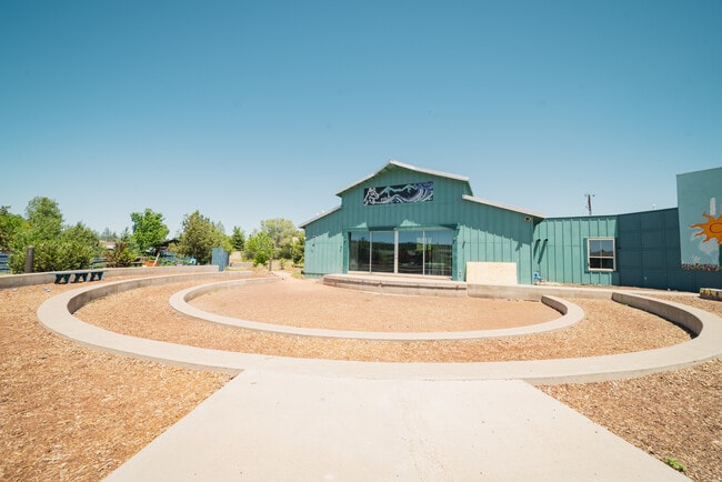


This Property Is For Sale
Current Lease Availabilities
Property Detail
3401 N Fort Valley Rd
111-02-004N
SERIAL: 2BE1123 YEAR: 1996 MAKE: MSI SIZE: 28X60, SERIAL: 2BE1124
Publicschool
COCONINO
B and X Area of moderate flood hazard, usually the area between the limits of the 100-year and 500-year floods.
Arizona
0
2.59 AC
2025
Flagstaff
000100
Other Market Areas
9,520 SF
Flagstaff, AZ
NEARBY LISTINGS FOR SALE OR LEASE
DEMOGRAPHICS near 3401 N Fort Valley Rd
1 mile
3 mile
5 mile
2025 Total Population
2,441
9,685
60,507
2030 Population
2,360
9,421
59,781
Pop Growth 2025-2030
(3.32%)
(2.73%)
(1.20%)
Average Age
41
39
32
2025 Total Households
904
3,931
19,386
HH Growth 2025-2030
(4.31%)
(3.69%)
(2.37%)
Median Household Inc
$115,368
$95,031
$66,591
Avg Household Size
2.60
2.30
2.40
2025 Avg HH Vehicles
2.00
2.00
2.00
Median Home Value
$657,682
$685,234
$592,025
Median Year Built
1983
1979
1991
Nearby Places
Map Layers
Map Styles
 Street
 Aerial
Layers
 Traffic
 Biking
Places
Listings with unknown addresses are not visible on the map
- Restaurants
- Banks
- Shops
- Fitness
- Groceries
PUBLIC TRANSPORTATION
COMMUTER RAIL
Flagstaff (Southwest Chief - Amtrak)
Drive
Walk
Distance
Flagstaff (Southwest Chief - Amtrak)
7 min
3.4 mi
AIRPORT
Flagstaff Pulliam
Drive
Walk
Distance
Flagstaff Pulliam
18 min
9.0 mi
Freight Ports
Port of San Diego
Drive
Walk
Distance
Port of San Diego
541 min
491.5 mi
Nearby Properties
Address
Land Use
TOTAL SIZE
Lot Size
Zoning
Address
Land Use
TOTAL SIZE
Lot Size
Zoning
385,095 SF
13.33 AC
Address
Land Use
TOTAL SIZE
Lot Size
Zoning
308,364 SF
2.43 AC
Address
Land Use
TOTAL SIZE
Lot Size
Zoning
167,731 SF
19.92 AC
Address
Land Use
TOTAL SIZE
Lot Size
Zoning
144,737 SF
15.01 AC
Address
Land Use
TOTAL SIZE
Lot Size
Zoning
125,784 SF
298.81 AC
Address
Land Use
TOTAL SIZE
Lot Size
Zoning
41,141 SF
0.92 AC
Address
Land Use
TOTAL SIZE
Lot Size
Zoning
75,751 SF
4.76 AC
Address
Land Use
TOTAL SIZE
Lot Size
Zoning
181,848 SF
21.01 AC
Address
Land Use
TOTAL SIZE
Lot Size
Zoning
51,619 SF
4.33 AC
Address
Land Use
TOTAL SIZE
Lot Size
Zoning
110,642 SF
12.40 AC
Address
Land Use
TOTAL SIZE
Lot Size
Zoning
50,798 SF
5 AC
Address
Land Use
TOTAL SIZE
Lot Size
Zoning
122,145 SF
12.23 AC
Address
Land Use
TOTAL SIZE
Lot Size
Zoning
40,653 SF
0.64 AC
Address
Land Use
TOTAL SIZE
Lot Size
Zoning
56,156 SF
5.56 AC
Address
Land Use
TOTAL SIZE
Lot Size
Zoning
65,539 SF
3.05 AC
Address
Land Use
TOTAL SIZE
Lot Size
Zoning
44,736 SF
4.66 AC
Address
Land Use
TOTAL SIZE
Lot Size
Zoning
75,268 SF
10 AC
Address
Land Use
TOTAL SIZE
Lot Size
Zoning
85,572 SF
0.95 AC
Address
Land Use
TOTAL SIZE
Lot Size
Zoning
87,356 SF
1.95 AC
Address
Land Use
TOTAL SIZE
Lot Size
Zoning
68,016 SF
0.54 AC
Address
Land Use
TOTAL SIZE
Lot Size
Zoning
26,312 SF
2.62 AC
Address
Land Use
TOTAL SIZE
Lot Size
Zoning
40,705 SF
0.43 AC
Address
Land Use
TOTAL SIZE
Lot Size
Zoning
71,005 SF
8.79 AC
Address
Land Use
TOTAL SIZE
Lot Size
Zoning
91,787 SF
3.34 AC
Address
Land Use
TOTAL SIZE
Lot Size
Zoning
8.74 AC
Address
Land Use
TOTAL SIZE
Lot Size
Zoning
39,685 SF
0.66 AC
Address
Land Use
TOTAL SIZE
Lot Size
Zoning
34,615 SF
3.06 AC
Address
Land Use
TOTAL SIZE
Lot Size
Zoning
19,400 SF
2.24 AC
Address
Land Use
TOTAL SIZE
Lot Size
Zoning
88,027 SF
7.48 AC
Address
Land Use
TOTAL SIZE
Lot Size
Zoning
18,162 SF
1.03 AC
The World's #1 Commercial Real Estate Marketplace
Connect with us
© 2026 CoStar Group
The information above has been obtained from sources believed reliable. While we do not doubt its accuracy we have not verified it and make no guarantee, warranty or representation about it. It is your responsibility to independently confirm its accuracy and completeness. Any projections, opinions, assumptions, or estimates used are for example only and do not represent the current or future performance of the property. The value of this transaction to you depends on tax and other factors which should be evaluated by your tax, financial, and legal advisors. You and your advisors should conduct a careful, independent investigation of the property to determine to your satisfaction the suitability of the property for your needs.