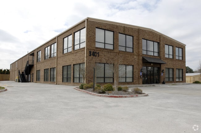
Property Record
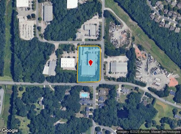
3401 Novis Pointe Nw, Acworth, GA 30101

NEARBY LISTINGS FOR SALE OR LEASE
Property Detail
3401 Novis Pointe Nw
Atlanta-Sandy Springs-Roswell, GA
East Acworth Industrl Park
20-0049-0-057-0
ALL THAT TRACT OR PARCEL OF LAND LYING AND BEING IN THE 20TH DISTRICT, 2ND SECTION, COBB COUNTY, GEORGIA, LYING WITHIN LAND LOT 49, IDENTIFIED AS TAX PARCEL 57, ON THE FIELD MAP
Commercialnec
Cobb
X
Georgia
13057C0325E
20
2025
2 AC
2025
Kennesaw/Acworth
030111
Atlanta
33,800 SF
DEMOGRAPHICS near 3401 Novis Pointe Nw
1 Mile
3 Mile
5 Mile
2024 Total Population
10,079
71,391
147,542
2029 Population
10,185
73,566
153,634
Pop Growth 2024-2029
+ 1.05%
+ 3.05%
+ 4.13%
Average Age
38
38
38
2024 Total Households
3,598
25,856
53,421
HH Growth 2024-2029
+ 1.03%
+ 2.95%
+ 4.15%
Median Household Inc
$88,952
$87,083
$85,344
Avg Household Size
2.80
2.70
2.70
2024 Avg HH Vehicles
2.00
2.00
2.00
Median Home Value
$276,735
$271,694
$283,151
Median Year Built
1995
1995
1994
Nearby Places
Map Layers
Map Styles
 Street
 Aerial
- Restaurants
- Banks
- Shops
- Fitness
- Groceries
SALE & LEASE HISTORY
LISTING DATE
SALE/LEASE

Apr 23, 2022
For Lease
Nearby Properties
Address
Land Use
TOTAL SIZE
Lot Size
Zoning
Address
Land Use
TOTAL SIZE
Lot Size
Zoning
497,466 SF
40.63 AC
RM-12
Address
Land Use
TOTAL SIZE
Lot Size
Zoning
342,443 SF
19.15 AC
NRC/RM12
Address
Land Use
TOTAL SIZE
Lot Size
Zoning
1,120 SF
42.20 AC
HI
Address
Land Use
TOTAL SIZE
Lot Size
Zoning
1,215,766 SF
39.92 AC
LI
Address
Land Use
TOTAL SIZE
Lot Size
Zoning
28,398 SF
22.95 AC
C1
Address
Land Use
TOTAL SIZE
Lot Size
Zoning
13.43 AC
OI
Address
Land Use
TOTAL SIZE
Lot Size
Zoning
7.53 AC
OI
Address
Land Use
TOTAL SIZE
Lot Size
Zoning
174,960 SF
3.99 AC
MU
Address
Land Use
TOTAL SIZE
Lot Size
Zoning
130,605 SF
21.38 AC
GC
Address
Land Use
TOTAL SIZE
Lot Size
Zoning
225,382 SF
18.67 AC
RM-8
Address
Land Use
TOTAL SIZE
Lot Size
Zoning
212,038 SF
24.96 AC
RM-8
Address
Land Use
TOTAL SIZE
Lot Size
Zoning
316,088 SF
18.27 AC
GC
Address
Land Use
TOTAL SIZE
Lot Size
Zoning
218,433 SF
26.38 AC
C2/R-8
Address
Land Use
TOTAL SIZE
Lot Size
Zoning
2,925 SF
1.25 AC
CBD
Address
Land Use
TOTAL SIZE
Lot Size
Zoning
200,596 SF
16.04 AC
RM-8
Address
Land Use
TOTAL SIZE
Lot Size
Zoning
311,900 SF
24.69 AC
LI
Address
Land Use
TOTAL SIZE
Lot Size
Zoning
147,079 SF
16.90 AC
C2/R-7
Address
Land Use
TOTAL SIZE
Lot Size
Zoning
195,600 SF
14.59 AC
LI
Address
Land Use
TOTAL SIZE
Lot Size
Zoning
204,948 SF
15 AC
RM-8
Address
Land Use
TOTAL SIZE
Lot Size
Zoning
652,178 SF
11.14 AC
LI
Address
Land Use
TOTAL SIZE
Lot Size
Zoning
128,292 SF
56.66 AC
I1
Address
Land Use
TOTAL SIZE
Lot Size
Zoning
115,210 SF
9.66 AC
RM-8
Address
Land Use
TOTAL SIZE
Lot Size
Zoning
138,482 SF
28.14 AC
R-40
Address
Land Use
TOTAL SIZE
Lot Size
Zoning
295,518 SF
18.83 AC
LI
Address
Land Use
TOTAL SIZE
Lot Size
Zoning
156,945 SF
18.03 AC
RM-8
Address
Land Use
TOTAL SIZE
Lot Size
Zoning
120,715 SF
14.60 AC
SLC
Address
Land Use
TOTAL SIZE
Lot Size
Zoning
113,376 SF
0.86 AC
SLC
Address
Land Use
TOTAL SIZE
Lot Size
Zoning
61,867 SF
4 AC
Address
Land Use
TOTAL SIZE
Lot Size
Zoning
111,673 SF
36.39 AC
Address
Land Use
TOTAL SIZE
Lot Size
Zoning
86,180 SF
54.76 AC
GC
The World's #1 Commercial Real Estate Marketplace
Connect with us
© 2025 CoStar Group
The information above has been obtained from sources believed reliable. While we do not doubt its accuracy we have not verified it and make no guarantee, warranty or representation about it. It is your responsibility to independently confirm its accuracy and completeness. Any projections, opinions, assumptions, or estimates used are for example only and do not represent the current or future performance of the property. The value of this transaction to you depends on tax and other factors which should be evaluated by your tax, financial, and legal advisors. You and your advisors should conduct a careful, independent investigation of the property to determine to your satisfaction the suitability of the property for your needs.