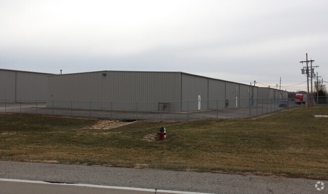
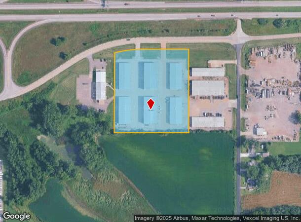
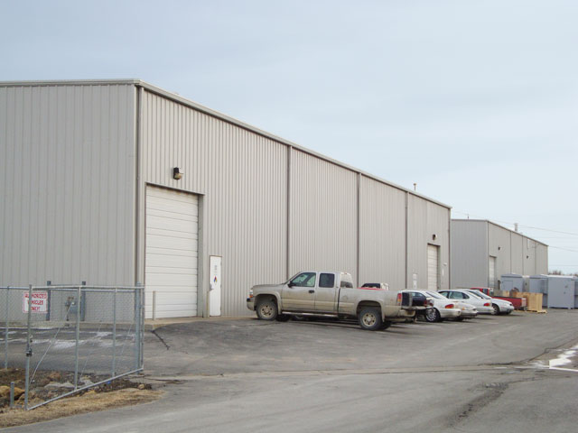
Property Record
3401 Nw Us Highway 24, Topeka, KS 66618
NEARBY LISTINGS FOR SALE OR LEASE
Property Detail
3401 Nw Us Highway 24
Topeka, KS
All American Sub
096-14-0-40-02-001-004
ALL AMERICAN SUB , BLOCK A , LOT 1 , THE E 734.39 OF LT 1 BLK A ALL AME RICAN SUB LESS TR DAF BEG SE COR LT 1 TH W 275 N 508 E 252 SE LY 48 S 463 TO POB SECTION 14 TOWNSHIP 11 RANGE 15
Commercialnec
Shawnee
X
Kansas
20177C0204E
1
2024
5.36 AC
2025
Topeka
003402
Kansas City
73,600 SF
DEMOGRAPHICS near 3401 Nw Us Highway 24
1 Mile
3 Mile
5 Mile
2024 Total Population
213
23,091
77,058
2029 Population
212
22,922
76,635
Pop Growth 2024-2029
(0.47%)
(0.73%)
(0.55%)
Average Age
39
41
40
2024 Total Households
79
10,057
33,251
HH Growth 2024-2029
(1.27%)
(0.81%)
(0.59%)
Median Household Inc
$59,444
$52,031
$49,479
Avg Household Size
2.40
2.20
2.20
2024 Avg HH Vehicles
2.00
2.00
2.00
Median Home Value
$116,667
$119,163
$114,323
Median Year Built
1982
1955
1958
Nearby Places
Map Layers
Map Styles
 Street
 Aerial
- Restaurants
- Banks
- Shops
- Fitness
- Groceries
PUBLIC TRANSPORTATION
COMMUTER RAIL
DRIVE
WALK
Distance
11 min
6.1 mi
Nearby Properties
Address
Land Use
TOTAL SIZE
Lot Size
Zoning
Address
Land Use
TOTAL SIZE
Lot Size
Zoning
513,835 SF
13.39 AC
M1
Address
Land Use
TOTAL SIZE
Lot Size
Zoning
309,298 SF
7.34 AC
M1
Address
Land Use
TOTAL SIZE
Lot Size
Zoning
90,929 SF
8.68 AC
PUD,OI3,I1
Address
Land Use
TOTAL SIZE
Lot Size
Zoning
114,523 SF
6.92 AC
OI3
Address
Land Use
TOTAL SIZE
Lot Size
Zoning
94,830 SF
17.09 AC
PUD,M4
Address
Land Use
TOTAL SIZE
Lot Size
Zoning
123,795 SF
16.45 AC
PUD,R1,I1,
Address
Land Use
TOTAL SIZE
Lot Size
Zoning
129,425 SF
96.26 AC
R1
Address
Land Use
TOTAL SIZE
Lot Size
Zoning
22,484 SF
75.33 AC
R1
Address
Land Use
TOTAL SIZE
Lot Size
Zoning
32,838 SF
3.25 AC
MS1
Address
Land Use
TOTAL SIZE
Lot Size
Zoning
116,026 SF
47.17 AC
R1
Address
Land Use
TOTAL SIZE
Lot Size
Zoning
44,567 SF
2.88 AC
MS1
Address
Land Use
TOTAL SIZE
Lot Size
Zoning
55,353 SF
12.40 AC
OI2
Address
Land Use
TOTAL SIZE
Lot Size
Zoning
15,880 SF
85.20 AC
R1
Address
Land Use
TOTAL SIZE
Lot Size
Zoning
67,302 SF
6.62 AC
OI2,OI3
Address
Land Use
TOTAL SIZE
Lot Size
Zoning
135,164 SF
11.01 AC
PUD,I1
Address
Land Use
TOTAL SIZE
Lot Size
Zoning
39,790 SF
3.76 AC
PUD
Address
Land Use
TOTAL SIZE
Lot Size
Zoning
44,143 SF
2.44 AC
OI2
Address
Land Use
TOTAL SIZE
Lot Size
Zoning
64,310 SF
12.95 AC
PUD,R1,I1,
Address
Land Use
TOTAL SIZE
Lot Size
Zoning
52,406 SF
4.87 AC
M1
Address
Land Use
TOTAL SIZE
Lot Size
Zoning
17,544 SF
42.80 AC
PUD,I1,M2,
Address
Land Use
TOTAL SIZE
Lot Size
Zoning
26,269 SF
8.18 AC
RR1
Address
Land Use
TOTAL SIZE
Lot Size
Zoning
64,318 SF
10.17 AC
RR1
Address
Land Use
TOTAL SIZE
Lot Size
Zoning
16,168 SF
1.62 AC
MS1
Address
Land Use
TOTAL SIZE
Lot Size
Zoning
51,285 SF
36.63 AC
PUD,I1,M2,
Address
Land Use
TOTAL SIZE
Lot Size
Zoning
18,984 SF
0.35 AC
HL,X3
Address
Land Use
TOTAL SIZE
Lot Size
Zoning
91,840 SF
13.75 AC
PUD,I1
Address
Land Use
TOTAL SIZE
Lot Size
Zoning
26,783 SF
3.11 AC
PUD,I1,M2,
Address
Land Use
TOTAL SIZE
Lot Size
Zoning
50,854 SF
4.42 AC
PUD,R1
Address
Land Use
TOTAL SIZE
Lot Size
Zoning
0.41 AC
OI2
Address
Land Use
TOTAL SIZE
Lot Size
Zoning
421,639 SF
30.15 AC
PUD,I1
The World's #1 Commercial Real Estate Marketplace
Connect with us
© 2026 CoStar Group
The information above has been obtained from sources believed reliable. While we do not doubt its accuracy we have not verified it and make no guarantee, warranty or representation about it. It is your responsibility to independently confirm its accuracy and completeness. Any projections, opinions, assumptions, or estimates used are for example only and do not represent the current or future performance of the property. The value of this transaction to you depends on tax and other factors which should be evaluated by your tax, financial, and legal advisors. You and your advisors should conduct a careful, independent investigation of the property to determine to your satisfaction the suitability of the property for your needs.