Property Record
3401 Rogers Rd, Wake Forest, NC 27587
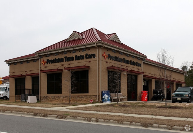

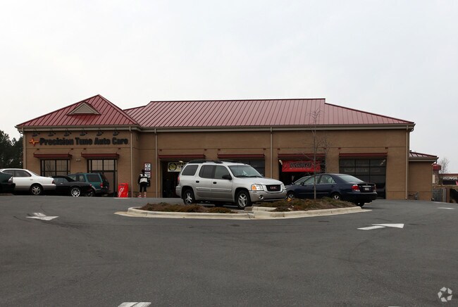
Property Detail
3401 Rogers Rd
1840.03-41-2249-000
LOFV 103-B FRANKLIN VILLAGE AT HERITAGE
Autorepair
WAKE
NB
North Carolina
B and X Area of moderate flood hazard, usually the area between the limits of the 100-year and 500-year floods.
0.99 AC
2025
Route 1
2025
Raleigh/Durham
054206
Raleigh-Cary, NC
5,392 SF
NEARBY LISTINGS FOR SALE OR LEASE
DEMOGRAPHICS near 3401 Rogers Rd
1 mile
3 mile
5 mile
2025 Total Population
8,876
64,823
125,122
2030 Population
9,737
70,478
135,927
Pop Growth 2025-2030
+ 9.70%
+ 8.72%
+ 8.64%
Average Age
39
39
39
2025 Total Households
3,393
23,895
45,601
HH Growth 2025-2030
+ 10.05%
+ 9.11%
+ 9.02%
Median Household Inc
$125,888
$120,502
$117,843
Avg Household Size
2.60
2.70
2.70
2025 Avg HH Vehicles
2.00
2.00
2.00
Median Home Value
$501,207
$482,290
$478,756
Median Year Built
2010
2007
2006
Nearby Places
Map Layers
Map Styles
 Street
 Aerial
Layers
 Traffic
 Biking
Places
Listings with unknown addresses are not visible on the map
- Restaurants
- Banks
- Shops
- Fitness
- Groceries
PUBLIC TRANSPORTATION
AIRPORT
Raleigh-Durham International
Drive
Walk
Distance
Raleigh-Durham International
31 min
20.1 mi
Nearby Properties
Address
Land Use
TOTAL SIZE
Lot Size
Zoning
Address
Land Use
TOTAL SIZE
Lot Size
Zoning
378,421 SF
19.06 AC
RMX
Address
Land Use
TOTAL SIZE
Lot Size
Zoning
283,870 SF
11.39 AC
RMX
Address
Land Use
TOTAL SIZE
Lot Size
Zoning
362,583 SF
26.53 AC
RX-3
Address
Land Use
TOTAL SIZE
Lot Size
Zoning
383,266 SF
52.30 AC
CX-3
Address
Land Use
TOTAL SIZE
Lot Size
Zoning
356,168 SF
26.68 AC
RMX
Address
Land Use
TOTAL SIZE
Lot Size
Zoning
442,480 SF
52.02 AC
GR3
Address
Land Use
TOTAL SIZE
Lot Size
Zoning
323,530 SF
37.96 AC
RX-3
Address
Land Use
TOTAL SIZE
Lot Size
Zoning
306,712 SF
14.03 AC
PUD
Address
Land Use
TOTAL SIZE
Lot Size
Zoning
263,777 SF
93.84 AC
GR3
Address
Land Use
TOTAL SIZE
Lot Size
Zoning
286,520 SF
22.55 AC
R-6
Address
Land Use
TOTAL SIZE
Lot Size
Zoning
232,734 SF
57.28 AC
GR3
Address
Land Use
TOTAL SIZE
Lot Size
Zoning
306,050 SF
30.45 AC
GR10
Address
Land Use
TOTAL SIZE
Lot Size
Zoning
194,593 SF
13.09 AC
CX-3
Address
Land Use
TOTAL SIZE
Lot Size
Zoning
188,828 SF
19.91 AC
OX-3
Address
Land Use
TOTAL SIZE
Lot Size
Zoning
243,797 SF
22.57 AC
GR10
Address
Land Use
TOTAL SIZE
Lot Size
Zoning
248,945 SF
16.41 AC
GR10
Address
Land Use
TOTAL SIZE
Lot Size
Zoning
225,390 SF
14.95 AC
GR10
Address
Land Use
TOTAL SIZE
Lot Size
Zoning
283,795 SF
31.33 AC
ICD
Address
Land Use
TOTAL SIZE
Lot Size
Zoning
162,909 SF
9.84 AC
RMX
Address
Land Use
TOTAL SIZE
Lot Size
Zoning
136,644 SF
4.38 AC
RMX
Address
Land Use
TOTAL SIZE
Lot Size
Zoning
186,546 SF
6.84 AC
RMX
Address
Land Use
TOTAL SIZE
Lot Size
Zoning
166,192 SF
13.59 AC
GR10
Address
Land Use
TOTAL SIZE
Lot Size
Zoning
143,060 SF
7.19 AC
RMX
Address
Land Use
TOTAL SIZE
Lot Size
Zoning
109,190 SF
1.46 AC
CX-5
Address
Land Use
TOTAL SIZE
Lot Size
Zoning
139,376 SF
4.80 AC
NX-4
Address
Land Use
TOTAL SIZE
Lot Size
Zoning
139,600 SF
23.64 AC
LI
Address
Land Use
TOTAL SIZE
Lot Size
Zoning
170,334 SF
23.99 AC
GR10
Address
Land Use
TOTAL SIZE
Lot Size
Zoning
104,919 SF
29.07 AC
GR3
Address
Land Use
TOTAL SIZE
Lot Size
Zoning
154,602 SF
40 AC
ICD
Address
Land Use
TOTAL SIZE
Lot Size
Zoning
137,650 SF
36.63 AC
GR5
The World's #1 Commercial Real Estate Marketplace
Connect with us
© 2026 CoStar Group
The information above has been obtained from sources believed reliable. While we do not doubt its accuracy we have not verified it and make no guarantee, warranty or representation about it. It is your responsibility to independently confirm its accuracy and completeness. Any projections, opinions, assumptions, or estimates used are for example only and do not represent the current or future performance of the property. The value of this transaction to you depends on tax and other factors which should be evaluated by your tax, financial, and legal advisors. You and your advisors should conduct a careful, independent investigation of the property to determine to your satisfaction the suitability of the property for your needs.