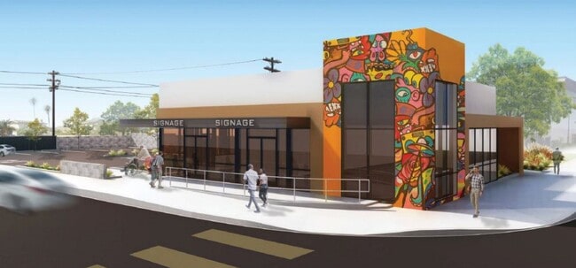
Property Record
3401 W Slauson Ave, Los Angeles, CA 90043


Current Lease Availabilities
NEARBY LISTINGS FOR SALE OR LEASE
Property Detail
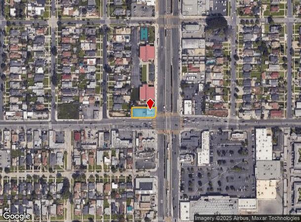
3401 W Slauson Ave
Los Angeles-Long Beach-Glendale, CA
911
5006-004-022
*TR=911*(EX OF ST) LOT 32
Restaurantbuilding
Los Angeles
X
California
06037C1777G
32
2024
0.25 AC
2025
Inglewood/South LA
234600
Los Angeles
2,286 SF
DEMOGRAPHICS near 3401 W Slauson Ave
1 Mile
3 Mile
5 Mile
2024 Total Population
39,592
349,430
1,036,532
2029 Population
38,434
337,901
1,000,853
Pop Growth 2024-2029
(2.92%)
(3.30%)
(3.44%)
Average Age
40
39
38
2024 Total Households
13,274
119,988
338,623
HH Growth 2024-2029
(3.16%)
(3.44%)
(3.50%)
Median Household Inc
$56,337
$58,850
$59,606
Avg Household Size
2.80
2.80
2.90
2024 Avg HH Vehicles
2.00
2.00
2.00
Median Home Value
$742,923
$736,593
$781,010
Median Year Built
1948
1951
1954
Nearby Places
Map Layers
Map Styles
 Street
 Aerial
- Restaurants
- Banks
- Shops
- Fitness
- Groceries
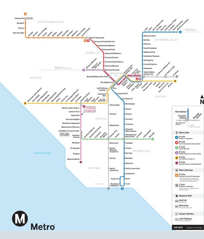
PUBLIC TRANSPORTATION
COMMUTER RAIL
DRIVE
WALK
Distance
17 min
9.7 mi
Union Station (91 Line - Southern California Regional Rail Authority (Metrolink), Antelope Valley Line - Southern California Regional Rail Authority (Metrolink), Orange County Line - Southern California Regional Rail Authority (Metrolink), Riverside Line - Southern California Regional Rail Authority (Metrolink), San Bernardino Line - Southern California Regional Rail Authority (Metrolink), Ventura County Line - Southern California Regional Rail Authority (Metrolink))
DRIVE
WALK
Distance
Union Station (91 Line - Southern California Regional Rail Authority (Metrolink), Antelope Valley Line - Southern California Regional Rail Authority (Metrolink), Orange County Line - Southern California Regional Rail Authority (Metrolink), Riverside Line - Southern California Regional Rail Authority (Metrolink), San Bernardino Line - Southern California Regional Rail Authority (Metrolink), Ventura County Line - Southern California Regional Rail Authority (Metrolink))
19 min
9.9 mi
AIRPORT
Los Angeles International
DRIVE
WALK
Distance
Los Angeles International
14 min
6.7 mi
Bob Hope
DRIVE
WALK
Distance
Bob Hope
36 min
18.0 mi
Long Beach (Daugherty Field)
DRIVE
WALK
Distance
Long Beach (Daugherty Field)
31 min
20.0 mi
Freight Ports
Port of Long Beach
DRIVE
WALK
Distance
Port of Long Beach
34 min
22.0 mi
Nearby Properties
Address
Land Use
TOTAL SIZE
Lot Size
Zoning
Address
Land Use
TOTAL SIZE
Lot Size
Zoning
2,531,696 SF
79.60 AC
INCR*
Address
Land Use
TOTAL SIZE
Lot Size
Zoning
724,715 SF
5.76 AC
INCR*
Address
Land Use
TOTAL SIZE
Lot Size
Zoning
1,359,630 SF
29 AC
INCR*
Address
Land Use
TOTAL SIZE
Lot Size
Zoning
102,877 SF
8.69 AC
LAC2
Address
Land Use
TOTAL SIZE
Lot Size
Zoning
343,879 SF
4.26 AC
LAC2
Address
Land Use
TOTAL SIZE
Lot Size
Zoning
569,916 SF
10.69 AC
LAR3
Address
Land Use
TOTAL SIZE
Lot Size
Zoning
181,213 SF
3.96 AC
INCR*
Address
Land Use
TOTAL SIZE
Lot Size
Zoning
273,825 SF
7.73 AC
INRM*
Address
Land Use
TOTAL SIZE
Lot Size
Zoning
377,831 SF
8.17 AC
LCC4*
Address
Land Use
TOTAL SIZE
Lot Size
Zoning
376,135 SF
8.02 AC
LCC4*
Address
Land Use
TOTAL SIZE
Lot Size
Zoning
144,111 SF
6.94 AC
INM1*
Address
Land Use
TOTAL SIZE
Lot Size
Zoning
102,789 SF
0.86 AC
INR3*
Address
Land Use
TOTAL SIZE
Lot Size
Zoning
57,488 SF
4.30 AC
LAPF
Address
Land Use
TOTAL SIZE
Lot Size
Zoning
0.35 AC
INC1*
Address
Land Use
TOTAL SIZE
Lot Size
Zoning
220,083 SF
4.95 AC
LAR3
Address
Land Use
TOTAL SIZE
Lot Size
Zoning
185,343 SF
1.27 AC
LAC1.5
Address
Land Use
TOTAL SIZE
Lot Size
Zoning
111,254 SF
5.63 AC
INCR
Address
Land Use
TOTAL SIZE
Lot Size
Zoning
233,461 SF
5.48 AC
1NM1*
Address
Land Use
TOTAL SIZE
Lot Size
Zoning
134,044 SF
1.90 AC
LAC2
Address
Land Use
TOTAL SIZE
Lot Size
Zoning
286,496 SF
9.60 AC
LAC2
Address
Land Use
TOTAL SIZE
Lot Size
Zoning
172,452 SF
3.31 AC
INR4*
Address
Land Use
TOTAL SIZE
Lot Size
Zoning
193,748 SF
6.91 AC
LAC2
Address
Land Use
TOTAL SIZE
Lot Size
Zoning
212,699 SF
7.11 AC
LAC2
Address
Land Use
TOTAL SIZE
Lot Size
Zoning
81,735 SF
4.10 AC
LAR4
Address
Land Use
TOTAL SIZE
Lot Size
Zoning
113,338 SF
1.58 AC
CCC3*
Address
Land Use
TOTAL SIZE
Lot Size
Zoning
267,463 SF
INCR
Address
Land Use
TOTAL SIZE
Lot Size
Zoning
203,718 SF
8.74 AC
INM1*
Address
Land Use
TOTAL SIZE
Lot Size
Zoning
82,970 SF
0.60 AC
INC3YY
Address
Land Use
TOTAL SIZE
Lot Size
Zoning
436,126 SF
1.95 AC
LAC2
The World's #1 Commercial Real Estate Marketplace
Connect with us
© 2026 CoStar Group
The information above has been obtained from sources believed reliable. While we do not doubt its accuracy we have not verified it and make no guarantee, warranty or representation about it. It is your responsibility to independently confirm its accuracy and completeness. Any projections, opinions, assumptions, or estimates used are for example only and do not represent the current or future performance of the property. The value of this transaction to you depends on tax and other factors which should be evaluated by your tax, financial, and legal advisors. You and your advisors should conduct a careful, independent investigation of the property to determine to your satisfaction the suitability of the property for your needs.