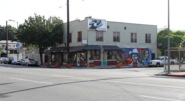
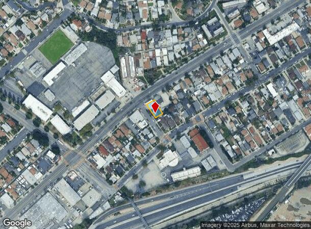
Property Record
415 Loreto St, Los Angeles, CA 90065
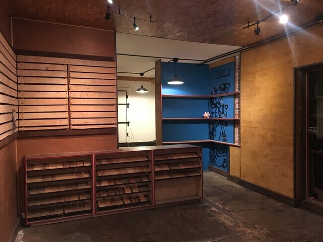
Current Lease Availabilities
NEARBY LISTINGS FOR SALE OR LEASE
-
-
-
-
-
-
-
-
-
-
-
-
-
-
-
-
-
-
No Photo
-
-
-
-
-
-
-
View all Los Angeles listings for lease on LoopNet.com
Property Detail
415 Loreto St
Los Angeles-Long Beach-Glendale, CA
Hunter Hlnd View
5446-020-016
RESUB OF LOT 37 OF THE HUNTER HIGHLAND VIEW TRACT EX OF ST LOT 15
Retailwithmorethanonenonretailuse
Los Angeles
X
California
06037C1629F
37,15
2024
0.13 AC
2025
Glendale
199002
Los Angeles
5,968 SF
DEMOGRAPHICS near 415 Loreto St
1 Mile
3 Mile
5 Mile
2024 Total Population
28,526
273,579
934,432
2029 Population
27,394
264,070
906,653
Pop Growth 2024-2029
(3.97%)
(3.48%)
(2.97%)
Average Age
40
39
39
2024 Total Households
9,419
94,095
351,033
HH Growth 2024-2029
(4.28%)
(3.74%)
(3.00%)
Median Household Inc
$67,306
$72,545
$64,301
Avg Household Size
2.90
2.70
2.50
2024 Avg HH Vehicles
2.00
2.00
1.00
Median Home Value
$824,407
$824,093
$851,916
Median Year Built
1948
1956
1959
Nearby Places
- Restaurants
- Banks
- Shops
- Fitness
- Groceries
PUBLIC TRANSPORTATION
TRANSIT/SUBWAY
Heritage Square/Arroyo Station (Gold Line - Los Angeles County Metropolitan Transportation Authority (Metro))
DRIVE
WALK
Distance
Heritage Square/Arroyo Station (Gold Line - Los Angeles County Metropolitan Transportation Authority (Metro))
2 min
8 min
0.4 mi
Lincoln Heights/Cypress Park Station (Gold Line - Los Angeles County Metropolitan Transportation Authority (Metro))
DRIVE
WALK
Distance
Lincoln Heights/Cypress Park Station (Gold Line - Los Angeles County Metropolitan Transportation Authority (Metro))
1 min
12 min
0.6 mi
COMMUTER RAIL
Los Angeles (Coast Starlight - Amtrak, Pacific Surfliner - Amtrak, Southwest Chief - Amtrak, Texas Eagle - Amtrak)
DRIVE
WALK
Distance
Los Angeles (Coast Starlight - Amtrak, Pacific Surfliner - Amtrak, Southwest Chief - Amtrak, Texas Eagle - Amtrak)
6 min
2.8 mi
Union Station (91 Line - Southern California Regional Rail Authority (Metrolink), Antelope Valley Line - Southern California Regional Rail Authority (Metrolink), Orange County Line - Southern California Regional Rail Authority (Metrolink), Riverside Line - Southern California Regional Rail Authority (Metrolink), San Bernardino Line - Southern California Regional Rail Authority (Metrolink), Ventura County Line - Southern California Regional Rail Authority (Metrolink))
DRIVE
WALK
Distance
Union Station (91 Line - Southern California Regional Rail Authority (Metrolink), Antelope Valley Line - Southern California Regional Rail Authority (Metrolink), Orange County Line - Southern California Regional Rail Authority (Metrolink), Riverside Line - Southern California Regional Rail Authority (Metrolink), San Bernardino Line - Southern California Regional Rail Authority (Metrolink), Ventura County Line - Southern California Regional Rail Authority (Metrolink))
8 min
2.9 mi
AIRPORT
Bob Hope
DRIVE
WALK
Distance
Bob Hope
21 min
14.9 mi
Los Angeles International
DRIVE
WALK
Distance
Los Angeles International
28 min
17.9 mi
Long Beach (Daugherty Field)
DRIVE
WALK
Distance
Long Beach (Daugherty Field)
34 min
23.4 mi
Freight Ports
Port of Long Beach
DRIVE
WALK
Distance
Port of Long Beach
36 min
26.2 mi
Nearby Properties
Address
Land Use
TOTAL SIZE
Lot Size
Zoning
Address
Land Use
TOTAL SIZE
Lot Size
Zoning
816,046 SF
15.37 AC
LAA1
Address
Land Use
TOTAL SIZE
Lot Size
Zoning
465,722 SF
5.84 AC
LAC4
Address
Land Use
TOTAL SIZE
Lot Size
Zoning
635,233 SF
12.02 AC
LAR5
Address
Land Use
TOTAL SIZE
Lot Size
Zoning
513,825 SF
4.28 AC
LAC2
Address
Land Use
TOTAL SIZE
Lot Size
Zoning
534,225 SF
Address
Land Use
TOTAL SIZE
Lot Size
Zoning
251,317 SF
114.56 AC
LAR1
Address
Land Use
TOTAL SIZE
Lot Size
Zoning
1,059,650 SF
1.07 AC
LAC2
Address
Land Use
TOTAL SIZE
Lot Size
Zoning
322,080 SF
2.85 AC
LAC2
Address
Land Use
TOTAL SIZE
Lot Size
Zoning
175.69 AC
LAA1
Address
Land Use
TOTAL SIZE
Lot Size
Zoning
328,737 SF
7.92 AC
LAC2
Address
Land Use
TOTAL SIZE
Lot Size
Zoning
642,160 SF
8.26 AC
LAADP
Address
Land Use
TOTAL SIZE
Lot Size
Zoning
368,058 SF
2.65 AC
LAUC (CA)
Address
Land Use
TOTAL SIZE
Lot Size
Zoning
354,299 SF
2.18 AC
LAC2
Address
Land Use
TOTAL SIZE
Lot Size
Zoning
150,608 SF
0.88 AC
LAC2
Address
Land Use
TOTAL SIZE
Lot Size
Zoning
318,903 SF
1.10 AC
LAC4
Address
Land Use
TOTAL SIZE
Lot Size
Zoning
223,783 SF
0.94 AC
LAC2
Address
Land Use
TOTAL SIZE
Lot Size
Zoning
252,825 SF
1.74 AC
LAC2
Address
Land Use
TOTAL SIZE
Lot Size
Zoning
342,600 SF
2.55 AC
LAC4
Address
Land Use
TOTAL SIZE
Lot Size
Zoning
209,559 SF
0.88 AC
LAR5
Address
Land Use
TOTAL SIZE
Lot Size
Zoning
225,923 SF
1.31 AC
LAR5
Address
Land Use
TOTAL SIZE
Lot Size
Zoning
224,969 SF
1.87 AC
LACW
Address
Land Use
TOTAL SIZE
Lot Size
Zoning
266,548 SF
4.59 AC
LAC4
Address
Land Use
TOTAL SIZE
Lot Size
Zoning
119,455 SF
5.04 AC
LACM
Address
Land Use
TOTAL SIZE
Lot Size
Zoning
53,760 SF
4.60 AC
LAM1
Address
Land Use
TOTAL SIZE
Lot Size
Zoning
252,559 SF
2.87 AC
LAC2
Address
Land Use
TOTAL SIZE
Lot Size
Zoning
195,526 SF
2.81 AC
LAADP
Address
Land Use
TOTAL SIZE
Lot Size
Zoning
358,305 SF
2.69 AC
LAC2
Address
Land Use
TOTAL SIZE
Lot Size
Zoning
133,598 SF
1.01 AC
LAC2
Address
Land Use
TOTAL SIZE
Lot Size
Zoning
329,063 SF
0.23 AC
LAC2
Address
Land Use
TOTAL SIZE
Lot Size
Zoning
212,165 SF
1.51 AC
LAC2
The World's #1 Commercial Real Estate Marketplace
Connect with us
© 2025 CoStar Group
The information above has been obtained from sources believed reliable. While we do not doubt its accuracy we have not verified it and make no guarantee, warranty or representation about it. It is your responsibility to independently confirm its accuracy and completeness. Any projections, opinions, assumptions, or estimates used are for example only and do not represent the current or future performance of the property. The value of this transaction to you depends on tax and other factors which should be evaluated by your tax, financial, and legal advisors. You and your advisors should conduct a careful, independent investigation of the property to determine to your satisfaction the suitability of the property for your needs.