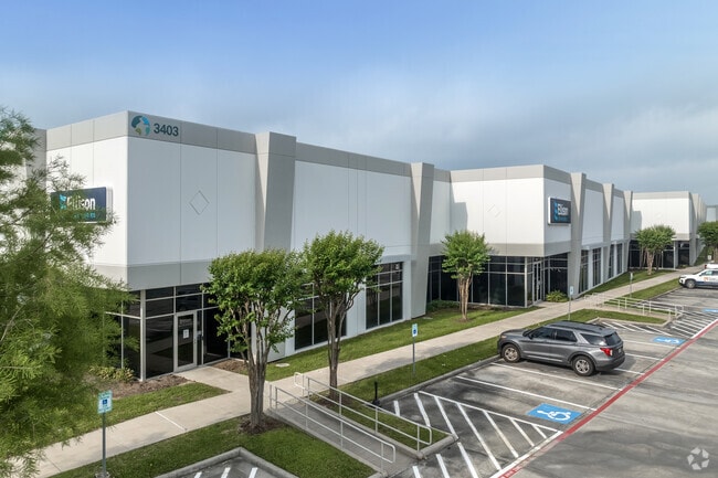
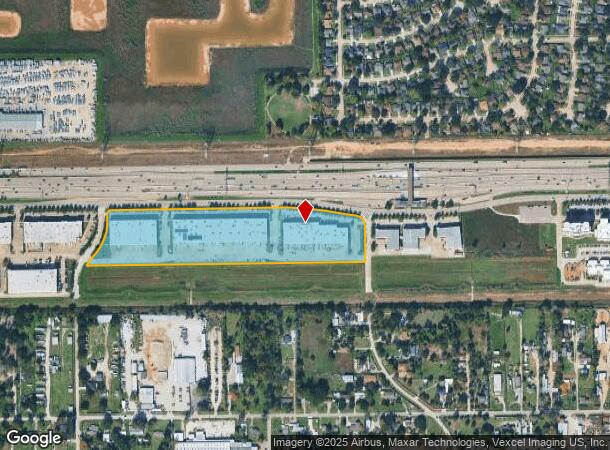
Property Record
3403 N Sam Houston Pkwy W, Houston, TX 77086
NEARBY LISTINGS FOR SALE OR LEASE
Property Detail
3403 N Sam Houston Pkwy W
1303480020001
Antoine Northwest Sec 1
Warehouse
RES C BLK 2 ANTOINE NORTHWEST SEC 1
AE
Harris
48201C0465M
Texas
2024
14.94 AC
2025
North Fwy/Tomball Pky
533802
Houston
200,123 SF
Houston-The Woodlands-Sugar Land, TX
DEMOGRAPHICS near 3403 N Sam Houston Pkwy W
1 Mile
3 Mile
5 Mile
2024 Total Population
10,660
115,257
322,203
2029 Population
10,737
116,104
326,782
Pop Growth 2024-2029
+ 0.72%
+ 0.73%
+ 1.42%
Average Age
35
35
35
2024 Total Households
2,979
33,570
104,464
HH Growth 2024-2029
+ 0.70%
+ 0.70%
+ 1.48%
Median Household Inc
$53,944
$56,501
$48,894
Avg Household Size
3.50
3.30
3.00
2024 Avg HH Vehicles
2.00
2.00
2.00
Median Home Value
$152,032
$165,931
$174,667
Median Year Built
1982
1987
1985
Nearby Places
Map Layers
Map Styles
 Street
 Aerial
- Restaurants
- Banks
- Shops
- Fitness
- Groceries
PUBLIC TRANSPORTATION
AIRPORT
George Bush Intcntl/Houston
DRIVE
WALK
Distance
George Bush Intcntl/Houston
16 min
11.8 mi
William P Hobby
DRIVE
WALK
Distance
William P Hobby
44 min
27.3 mi
Freight Ports
Port of Houston
DRIVE
WALK
Distance
Port of Houston
36 min
22.9 mi
SALE & LEASE HISTORY
LISTING DATE
SALE/LEASE

Sep 25, 2016
For Lease
Nearby Properties
Address
Land Use
TOTAL SIZE
Lot Size
Zoning
Address
Land Use
TOTAL SIZE
Lot Size
Zoning
858,420 SF
60.71 AC
Address
Land Use
TOTAL SIZE
Lot Size
Zoning
552,757 SF
32.95 AC
Address
Land Use
TOTAL SIZE
Lot Size
Zoning
614,256 SF
31.25 AC
Address
Land Use
TOTAL SIZE
Lot Size
Zoning
608,784 SF
29.08 AC
Address
Land Use
TOTAL SIZE
Lot Size
Zoning
504,000 SF
32.25 AC
Address
Land Use
TOTAL SIZE
Lot Size
Zoning
424,122 SF
21.06 AC
Address
Land Use
TOTAL SIZE
Lot Size
Zoning
356,900 SF
19.38 AC
Address
Land Use
TOTAL SIZE
Lot Size
Zoning
351,235 SF
20.73 AC
Address
Land Use
TOTAL SIZE
Lot Size
Zoning
284,687 SF
19.66 AC
Address
Land Use
TOTAL SIZE
Lot Size
Zoning
215,968 SF
17.23 AC
Address
Land Use
TOTAL SIZE
Lot Size
Zoning
356,656 SF
23.54 AC
Address
Land Use
TOTAL SIZE
Lot Size
Zoning
292,112 SF
4.41 AC
Address
Land Use
TOTAL SIZE
Lot Size
Zoning
614,712 SF
7.93 AC
Address
Land Use
TOTAL SIZE
Lot Size
Zoning
240,905 SF
19.98 AC
Address
Land Use
TOTAL SIZE
Lot Size
Zoning
241,946 SF
14.02 AC
Address
Land Use
TOTAL SIZE
Lot Size
Zoning
253,369 SF
16.81 AC
Address
Land Use
TOTAL SIZE
Lot Size
Zoning
261,000 SF
13.89 AC
Address
Land Use
TOTAL SIZE
Lot Size
Zoning
319,231 SF
14.97 AC
Address
Land Use
TOTAL SIZE
Lot Size
Zoning
318,135 SF
14.11 AC
Address
Land Use
TOTAL SIZE
Lot Size
Zoning
209,825 SF
11.97 AC
Address
Land Use
TOTAL SIZE
Lot Size
Zoning
213,200 SF
18.72 AC
Address
Land Use
TOTAL SIZE
Lot Size
Zoning
523,507 SF
38.28 AC
Address
Land Use
TOTAL SIZE
Lot Size
Zoning
397,012 SF
35.38 AC
Address
Land Use
TOTAL SIZE
Lot Size
Zoning
348,857 SF
20.06 AC
Address
Land Use
TOTAL SIZE
Lot Size
Zoning
188,236 SF
9.67 AC
Address
Land Use
TOTAL SIZE
Lot Size
Zoning
211,200 SF
8.10 AC
Address
Land Use
TOTAL SIZE
Lot Size
Zoning
221,760 SF
13.99 AC
Address
Land Use
TOTAL SIZE
Lot Size
Zoning
184,169 SF
8 AC
Address
Land Use
TOTAL SIZE
Lot Size
Zoning
166,500 SF
8.79 AC
The World's #1 Commercial Real Estate Marketplace
Connect with us
© 2025 CoStar Group
The information above has been obtained from sources believed reliable. While we do not doubt its accuracy we have not verified it and make no guarantee, warranty or representation about it. It is your responsibility to independently confirm its accuracy and completeness. Any projections, opinions, assumptions, or estimates used are for example only and do not represent the current or future performance of the property. The value of this transaction to you depends on tax and other factors which should be evaluated by your tax, financial, and legal advisors. You and your advisors should conduct a careful, independent investigation of the property to determine to your satisfaction the suitability of the property for your needs.