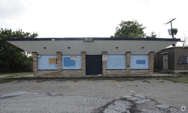
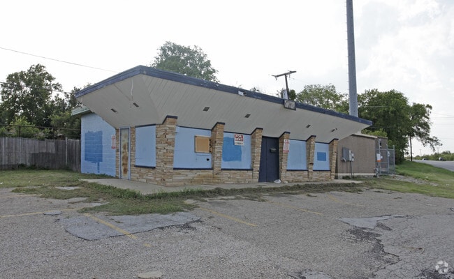
Property Record
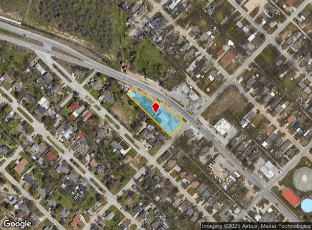
3405 Azle Ave, Fort Worth, TX 76106

NEARBY LISTINGS FOR SALE OR LEASE
Property Detail
3405 Azle Ave
Dallas-Fort Worth-Arlington, TX
Rosen Heights Second Filing
06863159
ROSEN HEIGHTS SECOND FILING BLOCK 228 LOT 1B
Commercialnec
Tarrant
X
Texas
48439C0170L
1b
2024
0.89 AC
2025
North Fort Worth
110402
Dallas/Ft Worth
5,044 SF
DEMOGRAPHICS near 3405 Azle Ave
1 mile
3 mile
5 mile
2024 Total Population
14,477
87,987
200,456
2029 Population
15,366
92,536
212,628
Pop Growth 2024-2029
+ 6.14%
+ 5.17%
+ 6.07%
Average Age
35
35
36
2024 Total Households
4,542
27,622
71,387
HH Growth 2024-2029
+ 6.27%
+ 5.29%
+ 6.43%
Median Household Inc
$51,540
$56,287
$67,877
Avg Household Size
3.10
3.10
2.70
2024 Avg HH Vehicles
2.00
2.00
2.00
Median Home Value
$117,154
$179,783
$233,712
Median Year Built
1972
1976
1990
Nearby Places
Map Layers
Map Styles
 Street
 Aerial
Transit
 Traffic
 Biking
Places
Listings with unknown addresses are not visible on the map
- Restaurants
- Banks
- Shops
- Fitness
- Groceries
PUBLIC TRANSPORTATION
COMMUTER RAIL
Fort Worth (Heartland Flyer - Amtrak, Texas Eagle - Amtrak)
Drive
Walk
Distance
Fort Worth (Heartland Flyer - Amtrak, Texas Eagle - Amtrak)
12 min
6.5 mi
Fort Worth Intermodal Transportation Center (Itc) (TRINITY RAILWAY - Dallas Area Rapid Transit (DART), Trinity Railway Express - Dallas Area Rapid Transit (DART))
Drive
Walk
Distance
Fort Worth Intermodal Transportation Center (Itc) (TRINITY RAILWAY - Dallas Area Rapid Transit (DART), Trinity Railway Express - Dallas Area Rapid Transit (DART))
12 min
6.5 mi
AIRPORT
Dallas-Fort Worth International
Drive
Walk
Distance
Dallas-Fort Worth International
37 min
28.9 mi
Freight Ports
Port of Shreveport
Drive
Walk
Distance
Port of Shreveport
257 min
236.8 mi
Nearby Properties
Address
Land Use
TOTAL SIZE
Lot Size
Zoning
Address
Land Use
TOTAL SIZE
Lot Size
Zoning
205,807 SF
3.19 AC
Address
Land Use
TOTAL SIZE
Lot Size
Zoning
1,291,500 SF
61.22 AC
Address
Land Use
TOTAL SIZE
Lot Size
Zoning
586,500 SF
159.54 AC
Address
Land Use
TOTAL SIZE
Lot Size
Zoning
431,028 SF
126.62 AC
Address
Land Use
TOTAL SIZE
Lot Size
Zoning
1,009,800 SF
49.98 AC
Address
Land Use
TOTAL SIZE
Lot Size
Zoning
307,139 SF
14.02 AC
Address
Land Use
TOTAL SIZE
Lot Size
Zoning
342,456 SF
15.56 AC
Address
Land Use
TOTAL SIZE
Lot Size
Zoning
531,597 SF
31.71 AC
Address
Land Use
TOTAL SIZE
Lot Size
Zoning
290,034 SF
11.04 AC
Address
Land Use
TOTAL SIZE
Lot Size
Zoning
293,830 SF
14.90 AC
Address
Land Use
TOTAL SIZE
Lot Size
Zoning
341,646 SF
17.63 AC
Address
Land Use
TOTAL SIZE
Lot Size
Zoning
225,140 SF
11.68 AC
Address
Land Use
TOTAL SIZE
Lot Size
Zoning
436,844 SF
1.25 AC
Address
Land Use
TOTAL SIZE
Lot Size
Zoning
254,610 SF
15.92 AC
Address
Land Use
TOTAL SIZE
Lot Size
Zoning
728,054 SF
33.51 AC
Address
Land Use
TOTAL SIZE
Lot Size
Zoning
319,219 SF
13.43 AC
Address
Land Use
TOTAL SIZE
Lot Size
Zoning
284,422 SF
119.90 AC
Address
Land Use
TOTAL SIZE
Lot Size
Zoning
505,500 SF
27.72 AC
Address
Land Use
TOTAL SIZE
Lot Size
Zoning
95,920 SF
3.13 AC
Address
Land Use
TOTAL SIZE
Lot Size
Zoning
91,398 SF
3.48 AC
Address
Land Use
TOTAL SIZE
Lot Size
Zoning
219,007 SF
10.91 AC
Address
Land Use
TOTAL SIZE
Lot Size
Zoning
618,728 SF
25.89 AC
Address
Land Use
TOTAL SIZE
Lot Size
Zoning
127,261 SF
83.50 AC
Address
Land Use
TOTAL SIZE
Lot Size
Zoning
184,765 SF
18.92 AC
Address
Land Use
TOTAL SIZE
Lot Size
Zoning
210,576 SF
10 AC
Address
Land Use
TOTAL SIZE
Lot Size
Zoning
127,761 SF
3.27 AC
Address
Land Use
TOTAL SIZE
Lot Size
Zoning
660,087 SF
23.55 AC
Address
Land Use
TOTAL SIZE
Lot Size
Zoning
428,400 SF
18.22 AC
Address
Land Use
TOTAL SIZE
Lot Size
Zoning
420,360 SF
27.67 AC
Address
Land Use
TOTAL SIZE
Lot Size
Zoning
100,410 SF
4.15 AC
The World's #1 Commercial Real Estate Marketplace
Connect with us
© 2026 CoStar Group
The information above has been obtained from sources believed reliable. While we do not doubt its accuracy we have not verified it and make no guarantee, warranty or representation about it. It is your responsibility to independently confirm its accuracy and completeness. Any projections, opinions, assumptions, or estimates used are for example only and do not represent the current or future performance of the property. The value of this transaction to you depends on tax and other factors which should be evaluated by your tax, financial, and legal advisors. You and your advisors should conduct a careful, independent investigation of the property to determine to your satisfaction the suitability of the property for your needs.