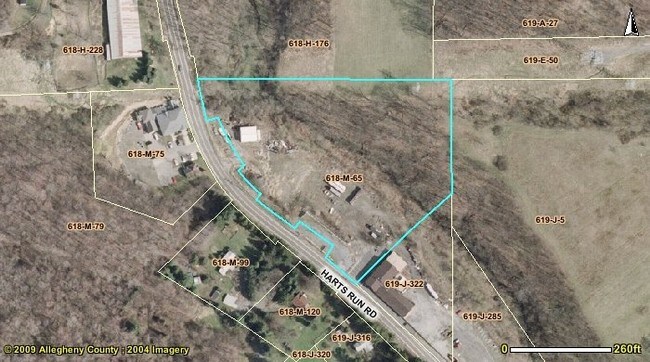
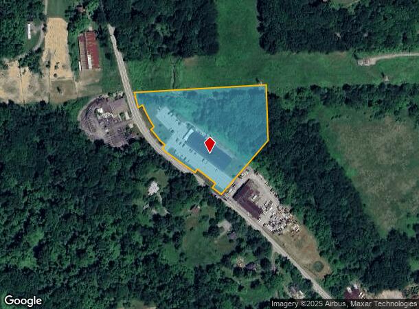
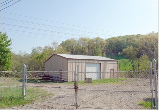
Property Record
3405 Harts Run Rd, Glenshaw, PA 15116

NEARBY LISTINGS FOR SALE OR LEASE
Property Detail
3405 Harts Run Rd
Pittsburgh, PA
M
0618-M-00065-0000-00
4.469 A LD HARTS RUN RD
Regionalshoppingcenterormallwithanchorstore
Allegheny
A
Pennsylvania
42003C0216H
65
2024
4.47 AC
2025
Northeast Pittsburgh
415001
Pittsburgh
DEMOGRAPHICS near 3405 Harts Run Rd
1 Mile
3 Mile
5 Mile
2024 Total Population
1,378
23,699
97,286
2029 Population
1,349
23,026
94,449
Pop Growth 2024-2029
(2.10%)
(2.84%)
(2.92%)
Average Age
43
45
44
2024 Total Households
514
9,293
40,564
HH Growth 2024-2029
(1.95%)
(2.88%)
(3.01%)
Median Household Inc
$122,158
$108,324
$96,134
Avg Household Size
2.60
2.50
2.30
2024 Avg HH Vehicles
2.00
2.00
2.00
Median Home Value
$349,029
$301,438
$272,938
Median Year Built
1966
1966
1964
Nearby Places
Map Layers
Map Styles
 Street
 Aerial
- Restaurants
- Banks
- Shops
- Fitness
- Groceries
PUBLIC TRANSPORTATION
AIRPORT
Pittsburgh International
DRIVE
WALK
Distance
Pittsburgh International
46 min
27.3 mi
Freight Ports
Port of Baltimore
DRIVE
WALK
Distance
Port of Baltimore
294 min
249.4 mi
Nearby Properties
Address
Land Use
TOTAL SIZE
Lot Size
Zoning
Address
Land Use
TOTAL SIZE
Lot Size
Zoning
115.10 AC
Address
Land Use
TOTAL SIZE
Lot Size
Zoning
4,242 SF
115.01 AC
Address
Land Use
TOTAL SIZE
Lot Size
Zoning
3,711 SF
11.07 AC
Address
Land Use
TOTAL SIZE
Lot Size
Zoning
Address
Land Use
TOTAL SIZE
Lot Size
Zoning
Address
Land Use
TOTAL SIZE
Lot Size
Zoning
4,836 SF
30.63 AC
Address
Land Use
TOTAL SIZE
Lot Size
Zoning
43.18 AC
Address
Land Use
TOTAL SIZE
Lot Size
Zoning
121.54 AC
Address
Land Use
TOTAL SIZE
Lot Size
Zoning
54.90 AC
Address
Land Use
TOTAL SIZE
Lot Size
Zoning
37.84 AC
Address
Land Use
TOTAL SIZE
Lot Size
Zoning
1,422 SF
162.05 AC
Address
Land Use
TOTAL SIZE
Lot Size
Zoning
72.14 AC
Address
Land Use
TOTAL SIZE
Lot Size
Zoning
11.03 AC
Address
Land Use
TOTAL SIZE
Lot Size
Zoning
Address
Land Use
TOTAL SIZE
Lot Size
Zoning
80.97 AC
Address
Land Use
TOTAL SIZE
Lot Size
Zoning
Address
Land Use
TOTAL SIZE
Lot Size
Zoning
Address
Land Use
TOTAL SIZE
Lot Size
Zoning
Address
Land Use
TOTAL SIZE
Lot Size
Zoning
11.97 AC
Address
Land Use
TOTAL SIZE
Lot Size
Zoning
Address
Land Use
TOTAL SIZE
Lot Size
Zoning
18.41 AC
Address
Land Use
TOTAL SIZE
Lot Size
Zoning
Address
Land Use
TOTAL SIZE
Lot Size
Zoning
19.45 AC
Address
Land Use
TOTAL SIZE
Lot Size
Zoning
900 SF
86.45 AC
Address
Land Use
TOTAL SIZE
Lot Size
Zoning
1,972 SF
365.87 AC
Address
Land Use
TOTAL SIZE
Lot Size
Zoning
Address
Land Use
TOTAL SIZE
Lot Size
Zoning
1,568 SF
1.48 AC
Address
Land Use
TOTAL SIZE
Lot Size
Zoning
Address
Land Use
TOTAL SIZE
Lot Size
Zoning
Address
Land Use
TOTAL SIZE
Lot Size
Zoning
The World's #1 Commercial Real Estate Marketplace
Connect with us
© 2025 CoStar Group
The information above has been obtained from sources believed reliable. While we do not doubt its accuracy we have not verified it and make no guarantee, warranty or representation about it. It is your responsibility to independently confirm its accuracy and completeness. Any projections, opinions, assumptions, or estimates used are for example only and do not represent the current or future performance of the property. The value of this transaction to you depends on tax and other factors which should be evaluated by your tax, financial, and legal advisors. You and your advisors should conduct a careful, independent investigation of the property to determine to your satisfaction the suitability of the property for your needs.