Property Record
3405 Steel Rail Dr, Bunnell, FL 32110
NEARBY LISTINGS FOR SALE OR LEASE
-
-
View all Bunnell listings for sale on LoopNet.com
Property Detail
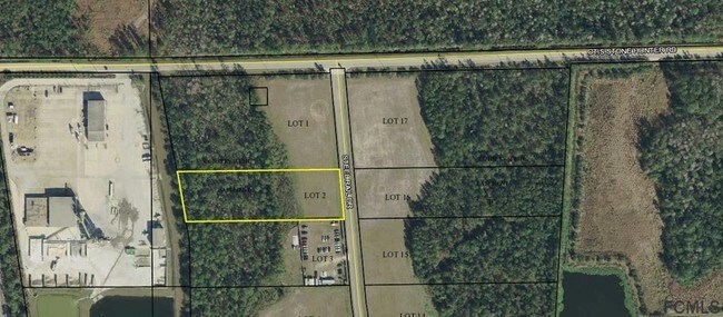
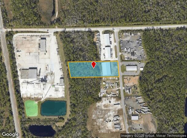
3405 Steel Rail Dr
Deltona-Daytona Beach-Ormond Beach, FL
Steel Rail Industrial Park
34-11-30-5736-00000-0020
STEEL RAIL INDUSTRIAL PARK REPLAT MB 37 PG 55 LOT 2 2.15 ACRES OR 2090/629 OR 2291/786
Industrialacreage
Flagler
A
Florida
12035C0120E
2
2024
2.15 AC
2025
Daytona Area
060206
Other Market Areas
DEMOGRAPHICS near 3405 Steel Rail Dr
1 Mile
3 Mile
5 Mile
2024 Total Population
1,574
26,331
60,333
2029 Population
1,913
32,074
73,554
Pop Growth 2024-2029
+ 21.54%
+ 21.81%
+ 21.91%
Average Age
42
46
46
2024 Total Households
562
10,509
23,827
HH Growth 2024-2029
+ 20.82%
+ 21.01%
+ 21.16%
Median Household Inc
$70,120
$63,486
$61,407
Avg Household Size
2.70
2.40
2.50
2024 Avg HH Vehicles
2.00
2.00
2.00
Median Home Value
$249,506
$258,027
$248,589
Median Year Built
2003
2001
2000
Nearby Places
- Restaurants
- Banks
- Shops
- Fitness
- Groceries
PUBLIC TRANSPORTATION
AIRPORT
Daytona Beach International
DRIVE
WALK
Distance
Daytona Beach International
42 min
30.2 mi
Freight Ports
Jacksonville Port
DRIVE
WALK
Distance
Jacksonville Port
81 min
67.3 mi
SALE & LEASE HISTORY
LISTING DATE
SALE/LEASE

Mar 19, 2018
For Sale
Nearby Properties
Address
Land Use
TOTAL SIZE
Lot Size
Zoning
Address
Land Use
TOTAL SIZE
Lot Size
Zoning
236,316 SF
61.38 AC
PSP
Address
Land Use
TOTAL SIZE
Lot Size
Zoning
138,991 SF
18.66 AC
P
Address
Land Use
TOTAL SIZE
Lot Size
Zoning
85,307 SF
4.31 AC
IND-1
Address
Land Use
TOTAL SIZE
Lot Size
Zoning
32,679 SF
101.42 AC
L-1
Address
Land Use
TOTAL SIZE
Lot Size
Zoning
112,200 SF
49.38 AC
L-1
Address
Land Use
TOTAL SIZE
Lot Size
Zoning
163,592 SF
10 AC
IND-1
Address
Land Use
TOTAL SIZE
Lot Size
Zoning
41,710 SF
11.97 AC
L-1
Address
Land Use
TOTAL SIZE
Lot Size
Zoning
48,777 SF
10.31 AC
PSP
Address
Land Use
TOTAL SIZE
Lot Size
Zoning
4,158 SF
3.73 AC
P
Address
Land Use
TOTAL SIZE
Lot Size
Zoning
66,485 SF
28.20 AC
Address
Land Use
TOTAL SIZE
Lot Size
Zoning
54,510 SF
6 AC
IND-2
Address
Land Use
TOTAL SIZE
Lot Size
Zoning
25,300 SF
5 AC
IND-1
Address
Land Use
TOTAL SIZE
Lot Size
Zoning
52,400 SF
8.06 AC
IND-1
Address
Land Use
TOTAL SIZE
Lot Size
Zoning
65,787 SF
11.88 AC
B-1
Address
Land Use
TOTAL SIZE
Lot Size
Zoning
41,849 SF
6 AC
IND-1
Address
Land Use
TOTAL SIZE
Lot Size
Zoning
55,468 SF
7.25 AC
O-1
Address
Land Use
TOTAL SIZE
Lot Size
Zoning
23,726 SF
8.58 AC
PSP
Address
Land Use
TOTAL SIZE
Lot Size
Zoning
29,872 SF
4 AC
IND-1
Address
Land Use
TOTAL SIZE
Lot Size
Zoning
36,988 SF
4.88 AC
IND-1
Address
Land Use
TOTAL SIZE
Lot Size
Zoning
35.41 AC
MFR-1
Address
Land Use
TOTAL SIZE
Lot Size
Zoning
36,576 SF
18.38 AC
I-C
Address
Land Use
TOTAL SIZE
Lot Size
Zoning
53,744 SF
75.79 AC
AC
Address
Land Use
TOTAL SIZE
Lot Size
Zoning
30 AC
AGR
Address
Land Use
TOTAL SIZE
Lot Size
Zoning
13.21 AC
Address
Land Use
TOTAL SIZE
Lot Size
Zoning
31,729 SF
4.01 AC
L-1
Address
Land Use
TOTAL SIZE
Lot Size
Zoning
22,505 SF
10.55 AC
PSP
Address
Land Use
TOTAL SIZE
Lot Size
Zoning
19,476 SF
8.81 AC
PSP
Address
Land Use
TOTAL SIZE
Lot Size
Zoning
12.87 AC
L-1
Address
Land Use
TOTAL SIZE
Lot Size
Zoning
23,456 SF
3.29 AC
C-2(F)
The World's #1 Commercial Real Estate Marketplace
Connect with us
© 2025 CoStar Group
The information above has been obtained from sources believed reliable. While we do not doubt its accuracy we have not verified it and make no guarantee, warranty or representation about it. It is your responsibility to independently confirm its accuracy and completeness. Any projections, opinions, assumptions, or estimates used are for example only and do not represent the current or future performance of the property. The value of this transaction to you depends on tax and other factors which should be evaluated by your tax, financial, and legal advisors. You and your advisors should conduct a careful, independent investigation of the property to determine to your satisfaction the suitability of the property for your needs.