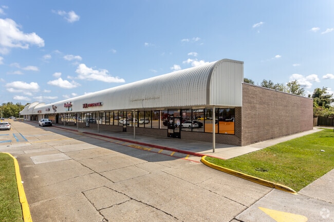
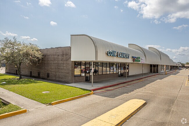
Property Record
3407 Lapalco Blvd, Harvey, LA 70058

Save to a Folder
{{folder.Name}}
{{folder.ListingIds.length}} Properties
{{folder.ListingIds.length}} Property
Create a New Folder
Property Detail
3407 Lapalco Blvd
New Orleans-Metairie, LA
HARVEY CANAL PROP 10932107 10932108
0400004821
Jefferson
Miscpropertynotclassed
Louisiana
2025
6.35 AC
2025
Outer Jefferson Parish
027811
New Orleans/Metairie/Kenner
NEARBY LISTINGS FOR SALE OR LEASE
-
-
-
-
-
No Photo
-
-
-
View all Harvey listings for lease on LoopNet.com
DEMOGRAPHICS near 3407 Lapalco Blvd
1 mile
3 mile
5 mile
2025 Total Population
9,614
93,119
212,719
2030 Population
9,443
91,180
208,020
Pop Growth 2025-2030
(1.78%)
(2.08%)
(2.21%)
Average Age
41
40
40
2025 Total Households
3,298
34,578
85,933
HH Growth 2025-2030
(1.85%)
(2.14%)
(2.36%)
Median Household Inc
$79,380
$53,819
$61,622
Avg Household Size
2.80
2.60
2.40
2025 Avg HH Vehicles
2.00
2.00
2.00
Median Home Value
$221,940
$215,112
$249,479
Median Year Built
1980
1976
1972
Nearby Places
Map Layers
Map Styles
 Street
 Aerial
Layers
 Traffic
 Biking
Places
Listings with unknown addresses are not visible on the map
- Restaurants
- Banks
- Shops
- Fitness
- Groceries
PUBLIC TRANSPORTATION
COMMUTER RAIL
New Orleans Union Passenger Terminal (City of New Orleans - Amtrak, Crescent - Amtrak, Sunset Limited - Amtrak)
Drive
Walk
Distance
New Orleans Union Passenger Terminal (City of New Orleans - Amtrak, Crescent - Amtrak, Sunset Limited - Amtrak)
16 min
9.4 mi
AIRPORT
Louis Armstrong New Orleans International
Drive
Walk
Distance
Louis Armstrong New Orleans International
34 min
23.8 mi
Freight Ports
Port of New Orleans
Drive
Walk
Distance
Port of New Orleans
21 min
10.1 mi
SALE & LEASE HISTORY
LISTING DATE
SALE/LEASE

May 01, 2025
For Lease
Mar 30, 2017
For Lease
Dec 17, 2019
For Lease
Aug 09, 2017
For Lease
Apr 24, 2019
For Lease
Nearby Properties
Address
Land Use
TOTAL SIZE
Lot Size
Zoning
Address
Land Use
TOTAL SIZE
Lot Size
Zoning
Address
Land Use
TOTAL SIZE
Lot Size
Zoning
0.14 AC
Address
Land Use
TOTAL SIZE
Lot Size
Zoning
Address
Land Use
TOTAL SIZE
Lot Size
Zoning
53.64 AC
Address
Land Use
TOTAL SIZE
Lot Size
Zoning
1.15 AC
Address
Land Use
TOTAL SIZE
Lot Size
Zoning
Address
Land Use
TOTAL SIZE
Lot Size
Zoning
0.17 AC
Address
Land Use
TOTAL SIZE
Lot Size
Zoning
0.23 AC
Address
Land Use
TOTAL SIZE
Lot Size
Zoning
12.79 AC
Address
Land Use
TOTAL SIZE
Lot Size
Zoning
0.16 AC
Address
Land Use
TOTAL SIZE
Lot Size
Zoning
14.69 AC
Address
Land Use
TOTAL SIZE
Lot Size
Zoning
0.14 AC
Address
Land Use
TOTAL SIZE
Lot Size
Zoning
20.52 AC
MUCD
Address
Land Use
TOTAL SIZE
Lot Size
Zoning
21.96 AC
MUCD
Address
Land Use
TOTAL SIZE
Lot Size
Zoning
Address
Land Use
TOTAL SIZE
Lot Size
Zoning
2.76 AC
Address
Land Use
TOTAL SIZE
Lot Size
Zoning
Address
Land Use
TOTAL SIZE
Lot Size
Zoning
0.14 AC
Address
Land Use
TOTAL SIZE
Lot Size
Zoning
16.87 AC
R1A
Address
Land Use
TOTAL SIZE
Lot Size
Zoning
0.18 AC
Address
Land Use
TOTAL SIZE
Lot Size
Zoning
42.23 AC
Address
Land Use
TOTAL SIZE
Lot Size
Zoning
31.14 AC
MUCD
Address
Land Use
TOTAL SIZE
Lot Size
Zoning
0.16 AC
Address
Land Use
TOTAL SIZE
Lot Size
Zoning
9.57 AC
Address
Land Use
TOTAL SIZE
Lot Size
Zoning
Address
Land Use
TOTAL SIZE
Lot Size
Zoning
12.33 AC
Address
Land Use
TOTAL SIZE
Lot Size
Zoning
0.12 AC
Address
Land Use
TOTAL SIZE
Lot Size
Zoning
0.14 AC
Address
Land Use
TOTAL SIZE
Lot Size
Zoning
0.22 AC
Address
Land Use
TOTAL SIZE
Lot Size
Zoning
The World's #1 Commercial Real Estate Marketplace
Connect with us
© 2026 CoStar Group
The information above has been obtained from sources believed reliable. While we do not doubt its accuracy we have not verified it and make no guarantee, warranty or representation about it. It is your responsibility to independently confirm its accuracy and completeness. Any projections, opinions, assumptions, or estimates used are for example only and do not represent the current or future performance of the property. The value of this transaction to you depends on tax and other factors which should be evaluated by your tax, financial, and legal advisors. You and your advisors should conduct a careful, independent investigation of the property to determine to your satisfaction the suitability of the property for your needs.