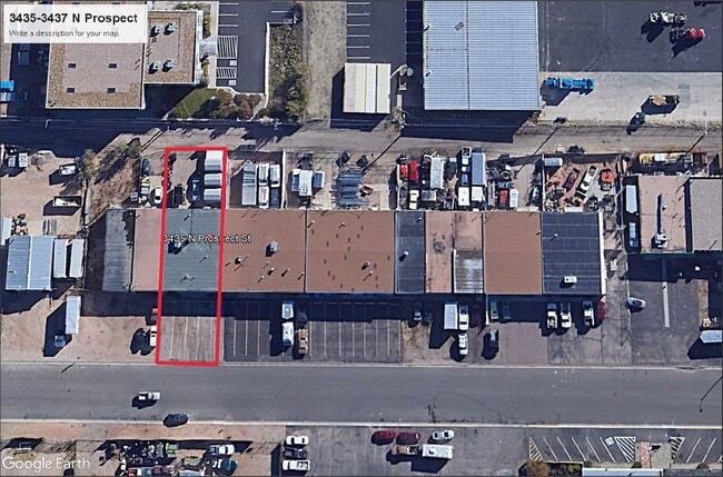
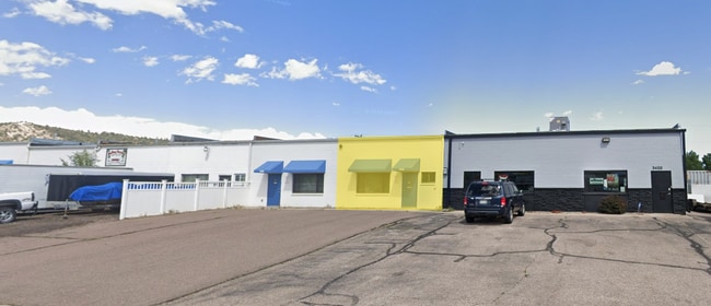
Property Record
3421 N Prospect St, Colorado Springs, CO 80907
This Property Is For Sale
NEARBY LISTINGS FOR SALE OR LEASE
Property Detail
3421 N Prospect St
Colorado Springs
Pikes Peak Industrial District
Colorado Springs, CO
LOT 5 FOSTER ELECTRIC
63293-02-010
El Paso
Warehouse
Colorado
2024
5
2025
0.08 AC
000302
North
1,320 SF
DEMOGRAPHICS near 3421 N Prospect St
1 Mile
3 Mile
5 Mile
2024 Total Population
9,534
89,207
250,663
2029 Population
9,836
92,753
261,180
Pop Growth 2024-2029
+ 3.17%
+ 3.98%
+ 4.20%
Average Age
41
41
40
2024 Total Households
4,272
39,315
107,886
HH Growth 2024-2029
+ 3.44%
+ 4.21%
+ 4.45%
Median Household Inc
$53,183
$65,488
$67,379
Avg Household Size
2.10
2.10
2.20
2024 Avg HH Vehicles
2.00
2.00
2.00
Median Home Value
$239,552
$381,428
$378,125
Median Year Built
1971
1973
1977
Nearby Places
Map Layers
Map Styles
 Street
 Aerial
- Restaurants
- Banks
- Shops
- Fitness
- Groceries
PUBLIC TRANSPORTATION
AIRPORT
City of Colorado Springs Municipal
DRIVE
WALK
Distance
City of Colorado Springs Municipal
24 min
10.9 mi
Nearby Properties
Address
Land Use
TOTAL SIZE
Lot Size
Zoning
Address
Land Use
TOTAL SIZE
Lot Size
Zoning
1,072,186 SF
15.14 AC
MX-N HR CU
Address
Land Use
TOTAL SIZE
Lot Size
Zoning
586,419 SF
17.77 AC
R-5 CU
Address
Land Use
TOTAL SIZE
Lot Size
Zoning
107,247 SF
56.98 AC
R-E PF
Address
Land Use
TOTAL SIZE
Lot Size
Zoning
662,208 SF
14.96 AC
BP
Address
Land Use
TOTAL SIZE
Lot Size
Zoning
604,992 SF
28.95 AC
MX-T CU
Address
Land Use
TOTAL SIZE
Lot Size
Zoning
271,048 SF
3.67 AC
FBZ-T2A
Address
Land Use
TOTAL SIZE
Lot Size
Zoning
62,201 SF
5.68 AC
MX-N
Address
Land Use
TOTAL SIZE
Lot Size
Zoning
167,120 SF
10.59 AC
MX-L/CR CU
Address
Land Use
TOTAL SIZE
Lot Size
Zoning
197,578 SF
7.98 AC
PDZ
Address
Land Use
TOTAL SIZE
Lot Size
Zoning
117,227 SF
12.28 AC
PDZ HS
Address
Land Use
TOTAL SIZE
Lot Size
Zoning
80,802 SF
14.45 AC
PF NNA
Address
Land Use
TOTAL SIZE
Lot Size
Zoning
198,916 SF
31.69 AC
PF/CR SS
Address
Land Use
TOTAL SIZE
Lot Size
Zoning
80,110 SF
2.61 AC
OR CU
Address
Land Use
TOTAL SIZE
Lot Size
Zoning
1,223 SF
725.94 AC
PF PK SS
Address
Land Use
TOTAL SIZE
Lot Size
Zoning
74,258 SF
4.60 AC
MX-T CU
Address
Land Use
TOTAL SIZE
Lot Size
Zoning
33,830 SF
1.09 AC
FBZ-T2A
Address
Land Use
TOTAL SIZE
Lot Size
Zoning
89,592 SF
7.60 AC
R-E CU
Address
Land Use
TOTAL SIZE
Lot Size
Zoning
71,542 SF
10.11 AC
PF
Address
Land Use
TOTAL SIZE
Lot Size
Zoning
134,592 SF
10.09 AC
MX-L LI CU
Address
Land Use
TOTAL SIZE
Lot Size
Zoning
39,627 SF
1.61 AC
R-5 SS
Address
Land Use
TOTAL SIZE
Lot Size
Zoning
131,696 SF
9.24 AC
MX-M
Address
Land Use
TOTAL SIZE
Lot Size
Zoning
100,930 SF
7.75 AC
BP CU
Address
Land Use
TOTAL SIZE
Lot Size
Zoning
99,488 SF
13.01 AC
PDZ
Address
Land Use
TOTAL SIZE
Lot Size
Zoning
45,044 SF
2 AC
R-1 6
Address
Land Use
TOTAL SIZE
Lot Size
Zoning
48,117 SF
2.96 AC
MX-M CU
Address
Land Use
TOTAL SIZE
Lot Size
Zoning
34,443 SF
5.14 AC
PF
Address
Land Use
TOTAL SIZE
Lot Size
Zoning
52,302 SF
1.74 AC
R-1 9 CU H
Address
Land Use
TOTAL SIZE
Lot Size
Zoning
49,023 SF
5.68 AC
MX-L NNA
Address
Land Use
TOTAL SIZE
Lot Size
Zoning
57,183 SF
1.83 AC
MX-T
Address
Land Use
TOTAL SIZE
Lot Size
Zoning
83,479 SF
0.03 AC
OC HS ??
The World's #1 Commercial Real Estate Marketplace
Connect with us
© 2026 CoStar Group
The information above has been obtained from sources believed reliable. While we do not doubt its accuracy we have not verified it and make no guarantee, warranty or representation about it. It is your responsibility to independently confirm its accuracy and completeness. Any projections, opinions, assumptions, or estimates used are for example only and do not represent the current or future performance of the property. The value of this transaction to you depends on tax and other factors which should be evaluated by your tax, financial, and legal advisors. You and your advisors should conduct a careful, independent investigation of the property to determine to your satisfaction the suitability of the property for your needs.