Property Record
3409 Brinkman St, Houston, TX 77018

NEARBY LISTINGS FOR SALE OR LEASE
Property Detail
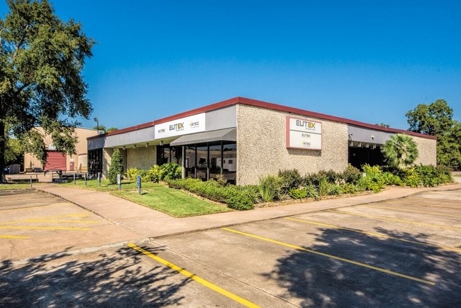
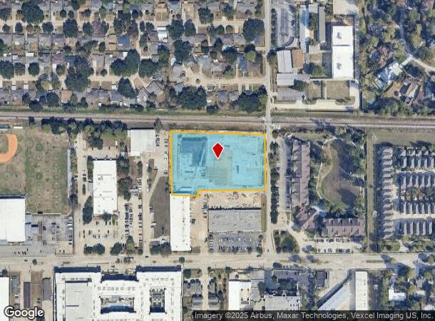
3409 Brinkman St
1050770000010
Dead Oak
Apartment
RES A DEAD OAK
X
Harris
48201C0660M
Texas
2024
2.77 AC
2025
Northwest Near
530200
Houston
402,433 SF
Houston-The Woodlands-Sugar Land, TX
DEMOGRAPHICS near 3409 Brinkman St
1 Mile
3 Mile
5 Mile
2024 Total Population
16,724
149,712
402,581
2029 Population
17,447
155,679
416,653
Pop Growth 2024-2029
+ 4.32%
+ 3.99%
+ 3.50%
Average Age
37
37
37
2024 Total Households
7,302
63,738
166,300
HH Growth 2024-2029
+ 4.42%
+ 4.03%
+ 3.71%
Median Household Inc
$123,549
$82,129
$70,701
Avg Household Size
2.30
2.30
2.40
2024 Avg HH Vehicles
2.00
2.00
2.00
Median Home Value
$459,890
$433,295
$382,871
Median Year Built
2003
1978
1983
Nearby Places
Map Layers
Map Styles
 Street
 Aerial
- Restaurants
- Banks
- Shops
- Fitness
- Groceries
PUBLIC TRANSPORTATION
COMMUTER RAIL
Houston (Sunset Limited - Amtrak)
DRIVE
WALK
Distance
Houston (Sunset Limited - Amtrak)
12 min
6.5 mi
AIRPORT
William P Hobby
DRIVE
WALK
Distance
William P Hobby
32 min
19.4 mi
George Bush Intcntl/Houston
DRIVE
WALK
Distance
George Bush Intcntl/Houston
25 min
19.7 mi
Freight Ports
Port of Houston
DRIVE
WALK
Distance
Port of Houston
24 min
15.0 mi
SALE & LEASE HISTORY
LISTING DATE
SALE/LEASE

Sep 25, 2017
For Lease
Sep 24, 2016
For Lease
Nov 11, 2019
For Sale
Mar 10, 2017
For Sale
Nearby Properties
Address
Land Use
TOTAL SIZE
Lot Size
Zoning
Address
Land Use
TOTAL SIZE
Lot Size
Zoning
453,456 SF
3.11 AC
Address
Land Use
TOTAL SIZE
Lot Size
Zoning
519,374 SF
6.18 AC
Address
Land Use
TOTAL SIZE
Lot Size
Zoning
563,626 SF
4.71 AC
Address
Land Use
TOTAL SIZE
Lot Size
Zoning
474,326 SF
43.16 AC
Address
Land Use
TOTAL SIZE
Lot Size
Zoning
315,439 SF
3.54 AC
Address
Land Use
TOTAL SIZE
Lot Size
Zoning
432,691 SF
3.26 AC
Address
Land Use
TOTAL SIZE
Lot Size
Zoning
324,709 SF
4 AC
Address
Land Use
TOTAL SIZE
Lot Size
Zoning
261,312 SF
1.81 AC
Address
Land Use
TOTAL SIZE
Lot Size
Zoning
457,647 SF
2.30 AC
Address
Land Use
TOTAL SIZE
Lot Size
Zoning
593,265 SF
3.73 AC
Address
Land Use
TOTAL SIZE
Lot Size
Zoning
366,386 SF
10.85 AC
Address
Land Use
TOTAL SIZE
Lot Size
Zoning
375,693 SF
9.16 AC
Address
Land Use
TOTAL SIZE
Lot Size
Zoning
255,545 SF
2.91 AC
Address
Land Use
TOTAL SIZE
Lot Size
Zoning
264,101 SF
3.58 AC
Address
Land Use
TOTAL SIZE
Lot Size
Zoning
279,934 SF
8 AC
Address
Land Use
TOTAL SIZE
Lot Size
Zoning
379,725 SF
2.84 AC
Address
Land Use
TOTAL SIZE
Lot Size
Zoning
587,156 SF
4.40 AC
Address
Land Use
TOTAL SIZE
Lot Size
Zoning
440,577 SF
4.13 AC
Address
Land Use
TOTAL SIZE
Lot Size
Zoning
270,845 SF
10.75 AC
Address
Land Use
TOTAL SIZE
Lot Size
Zoning
443,228 SF
3.15 AC
Address
Land Use
TOTAL SIZE
Lot Size
Zoning
87,179 SF
4.13 AC
Address
Land Use
TOTAL SIZE
Lot Size
Zoning
322,880 SF
2.61 AC
Address
Land Use
TOTAL SIZE
Lot Size
Zoning
363,503 SF
12.81 AC
Address
Land Use
TOTAL SIZE
Lot Size
Zoning
263,475 SF
7.90 AC
Address
Land Use
TOTAL SIZE
Lot Size
Zoning
104,455 SF
5.58 AC
Address
Land Use
TOTAL SIZE
Lot Size
Zoning
280,241 SF
1.90 AC
Address
Land Use
TOTAL SIZE
Lot Size
Zoning
418,456 SF
5.72 AC
Address
Land Use
TOTAL SIZE
Lot Size
Zoning
123,494 SF
6.40 AC
Address
Land Use
TOTAL SIZE
Lot Size
Zoning
394,910 SF
15.04 AC
The World's #1 Commercial Real Estate Marketplace
Connect with us
© 2026 CoStar Group
The information above has been obtained from sources believed reliable. While we do not doubt its accuracy we have not verified it and make no guarantee, warranty or representation about it. It is your responsibility to independently confirm its accuracy and completeness. Any projections, opinions, assumptions, or estimates used are for example only and do not represent the current or future performance of the property. The value of this transaction to you depends on tax and other factors which should be evaluated by your tax, financial, and legal advisors. You and your advisors should conduct a careful, independent investigation of the property to determine to your satisfaction the suitability of the property for your needs.