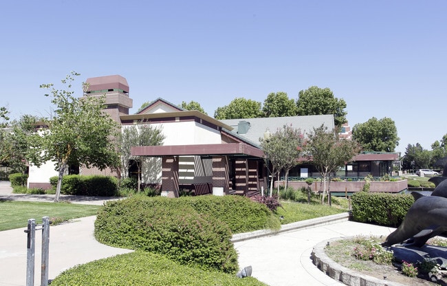
Property Record
3409 Brookside Rd, Stockton, CA 95219


NEARBY LISTINGS FOR SALE OR LEASE
Property Detail
3409 Brookside Rd
116-280-07
Brookside Estates 02
Medicalbuilding
REDRAWN OCT-16-1996 FROM ORIGINAL APN 114-360-09
X
San Joaquin
06077C0455F
California
2025
0.72 AC
2025
Stockton
003119
Stockton/Modesto
10,488 SF
Stockton-Lodi, CA
DEMOGRAPHICS near 3409 Brookside Rd
1 Mile
3 Mile
5 Mile
2024 Total Population
13,622
97,130
259,730
2029 Population
14,327
102,289
273,869
Pop Growth 2024-2029
+ 5.18%
+ 5.31%
+ 5.44%
Average Age
41
38
37
2024 Total Households
5,044
35,756
85,235
HH Growth 2024-2029
+ 5.13%
+ 5.41%
+ 5.56%
Median Household Inc
$108,527
$74,562
$69,418
Avg Household Size
2.70
2.60
2.90
2024 Avg HH Vehicles
2.00
2.00
2.00
Median Home Value
$608,087
$416,045
$379,029
Median Year Built
1991
1972
1975
Nearby Places
Map Layers
Map Styles
 Street
 Aerial
- Restaurants
- Banks
- Shops
- Fitness
- Groceries
PUBLIC TRANSPORTATION
COMMUTER RAIL
DRIVE
WALK
Distance
11 min
5.8 mi
Stockton (Altamont Corridor Express - Altamont Commuter Express (ACE))
DRIVE
WALK
Distance
Stockton (Altamont Corridor Express - Altamont Commuter Express (ACE))
11 min
6.3 mi
AIRPORT
Stockton Metro
DRIVE
WALK
Distance
Stockton Metro
18 min
11.1 mi
Freight Ports
Port of Stockton
DRIVE
WALK
Distance
Port of Stockton
8 min
3.6 mi
SALE & LEASE HISTORY
LISTING DATE
SALE/LEASE

May 16, 2023
For Sale
Nearby Properties
Address
Land Use
TOTAL SIZE
Lot Size
Zoning
Address
Land Use
TOTAL SIZE
Lot Size
Zoning
30,080 SF
82.44 AC
Address
Land Use
TOTAL SIZE
Lot Size
Zoning
60,137 SF
7.22 AC
Address
Land Use
TOTAL SIZE
Lot Size
Zoning
10,208 SF
47.57 AC
Address
Land Use
TOTAL SIZE
Lot Size
Zoning
22.89 AC
Address
Land Use
TOTAL SIZE
Lot Size
Zoning
161,229 SF
10.16 AC
Address
Land Use
TOTAL SIZE
Lot Size
Zoning
23,112 SF
9.20 AC
Address
Land Use
TOTAL SIZE
Lot Size
Zoning
151,271 SF
8.97 AC
Address
Land Use
TOTAL SIZE
Lot Size
Zoning
82,512 SF
4.14 AC
Address
Land Use
TOTAL SIZE
Lot Size
Zoning
18.66 AC
Address
Land Use
TOTAL SIZE
Lot Size
Zoning
97,276 SF
5.46 AC
RHD
Address
Land Use
TOTAL SIZE
Lot Size
Zoning
190,923 SF
3.96 AC
Address
Land Use
TOTAL SIZE
Lot Size
Zoning
17,573 SF
3.17 AC
Address
Land Use
TOTAL SIZE
Lot Size
Zoning
14,035 SF
10.02 AC
Address
Land Use
TOTAL SIZE
Lot Size
Zoning
77,568 SF
2.58 AC
Address
Land Use
TOTAL SIZE
Lot Size
Zoning
5,888 SF
3.64 AC
Address
Land Use
TOTAL SIZE
Lot Size
Zoning
119,341 SF
7.98 AC
Address
Land Use
TOTAL SIZE
Lot Size
Zoning
176,492 SF
10.55 AC
Address
Land Use
TOTAL SIZE
Lot Size
Zoning
146,660 SF
8.35 AC
Address
Land Use
TOTAL SIZE
Lot Size
Zoning
2,880 SF
36.83 AC
Address
Land Use
TOTAL SIZE
Lot Size
Zoning
5.70 AC
RL
Address
Land Use
TOTAL SIZE
Lot Size
Zoning
44,752 SF
2.31 AC
Address
Land Use
TOTAL SIZE
Lot Size
Zoning
11,720 SF
4.28 AC
Address
Land Use
TOTAL SIZE
Lot Size
Zoning
95,592 SF
3.20 AC
O
Address
Land Use
TOTAL SIZE
Lot Size
Zoning
64,656 SF
3.55 AC
Address
Land Use
TOTAL SIZE
Lot Size
Zoning
55,228 SF
4.04 AC
Address
Land Use
TOTAL SIZE
Lot Size
Zoning
46,982 SF
2.26 AC
Address
Land Use
TOTAL SIZE
Lot Size
Zoning
105,948 SF
9.70 AC
Address
Land Use
TOTAL SIZE
Lot Size
Zoning
59,524 SF
2.69 AC
Address
Land Use
TOTAL SIZE
Lot Size
Zoning
60,840 SF
10 AC
CC
The World's #1 Commercial Real Estate Marketplace
Connect with us
© 2026 CoStar Group
The information above has been obtained from sources believed reliable. While we do not doubt its accuracy we have not verified it and make no guarantee, warranty or representation about it. It is your responsibility to independently confirm its accuracy and completeness. Any projections, opinions, assumptions, or estimates used are for example only and do not represent the current or future performance of the property. The value of this transaction to you depends on tax and other factors which should be evaluated by your tax, financial, and legal advisors. You and your advisors should conduct a careful, independent investigation of the property to determine to your satisfaction the suitability of the property for your needs.