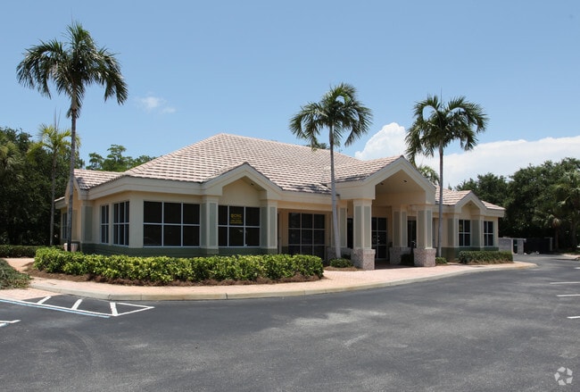
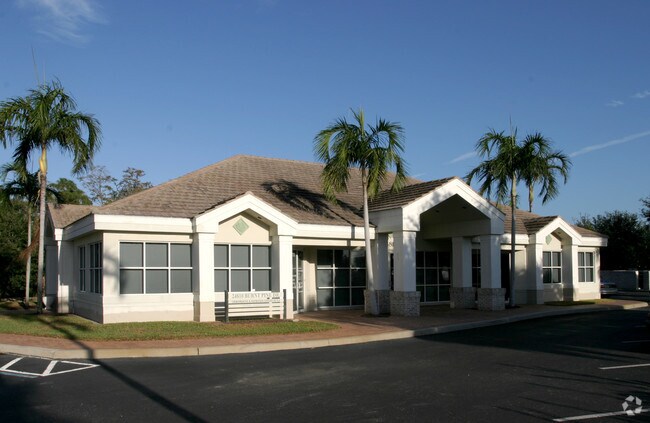
Property Record
24810 Burnt Pine Dr, Bonita Springs, FL 34134

NEARBY LISTINGS FOR SALE OR LEASE
Property Detail
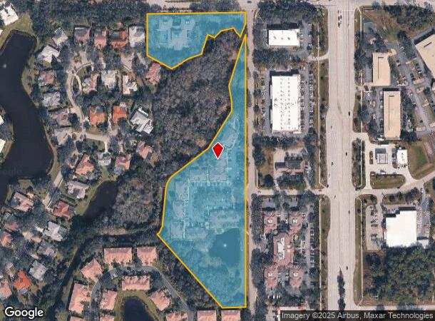
24810 Burnt Pine Dr
16-47-25-B3-00002.1020
S. 41 To Bonita
Officebuilding
PAR IN SE 1/4 OF SEC W OF US 41 - DESC OR 2352/0893 AKA PAR B + F
AE
Lee
12071C0593H
Florida
2024
7.93 AC
2025
Bonita Springs
050322
Southwest Florida
62,484 SF
Cape Coral-Fort Myers, FL
DEMOGRAPHICS near 24810 Burnt Pine Dr
1 Mile
3 Mile
5 Mile
2024 Total Population
4,534
39,986
95,275
2029 Population
5,511
48,206
114,835
Pop Growth 2024-2029
+ 21.55%
+ 20.56%
+ 20.53%
Average Age
66
59
56
2024 Total Households
2,465
19,663
45,600
HH Growth 2024-2029
+ 21.18%
+ 20.36%
+ 20.29%
Median Household Inc
$104,023
$90,313
$83,013
Avg Household Size
1.80
2.00
2.00
2024 Avg HH Vehicles
2.00
2.00
2.00
Median Home Value
$441,424
$437,243
$387,807
Median Year Built
1996
1999
1998
Nearby Places
Map Layers
Map Styles
 Street
 Aerial
- Restaurants
- Banks
- Shops
- Fitness
- Groceries
PUBLIC TRANSPORTATION
AIRPORT
Southwest Florida International
DRIVE
WALK
Distance
Southwest Florida International
27 min
17.2 mi
Nearby Properties
Address
Land Use
TOTAL SIZE
Lot Size
Zoning
Address
Land Use
TOTAL SIZE
Lot Size
Zoning
785,522 SF
70.04 AC
MPD
Address
Land Use
TOTAL SIZE
Lot Size
Zoning
177,930 SF
20.74 AC
MPD
Address
Land Use
TOTAL SIZE
Lot Size
Zoning
687,668 SF
27.19 AC
CPD
Address
Land Use
TOTAL SIZE
Lot Size
Zoning
406,601 SF
19.88 AC
RPD
Address
Land Use
TOTAL SIZE
Lot Size
Zoning
221,244 SF
65.55 AC
MPD
Address
Land Use
TOTAL SIZE
Lot Size
Zoning
540,648 SF
19.75 AC
MPD
Address
Land Use
TOTAL SIZE
Lot Size
Zoning
293,332 SF
7.03 AC
CPD
Address
Land Use
TOTAL SIZE
Lot Size
Zoning
274,691 SF
6.62 AC
MPD
Address
Land Use
TOTAL SIZE
Lot Size
Zoning
464,234 SF
22.53 AC
CPD
Address
Land Use
TOTAL SIZE
Lot Size
Zoning
48,538 SF
4.46 AC
CC
Address
Land Use
TOTAL SIZE
Lot Size
Zoning
97,916 SF
19.72 AC
CF-2
Address
Land Use
TOTAL SIZE
Lot Size
Zoning
181,680 SF
9.89 AC
MPD
Address
Land Use
TOTAL SIZE
Lot Size
Zoning
8.87 AC
CT
Address
Land Use
TOTAL SIZE
Lot Size
Zoning
144,993 SF
8.73 AC
PUD
Address
Land Use
TOTAL SIZE
Lot Size
Zoning
35,085 SF
1.70 AC
TFC2
Address
Land Use
TOTAL SIZE
Lot Size
Zoning
103,495 SF
13.29 AC
CPD
Address
Land Use
TOTAL SIZE
Lot Size
Zoning
126,947 SF
15.86 AC
CF-2
Address
Land Use
TOTAL SIZE
Lot Size
Zoning
87,430 SF
7.30 AC
IPD
Address
Land Use
TOTAL SIZE
Lot Size
Zoning
67,650 SF
2.27 AC
MPD
Address
Land Use
TOTAL SIZE
Lot Size
Zoning
73,370 SF
2.42 AC
MPD
Address
Land Use
TOTAL SIZE
Lot Size
Zoning
137,260 SF
5.37 AC
CPD
Address
Land Use
TOTAL SIZE
Lot Size
Zoning
84,782 SF
8.30 AC
MPD
Address
Land Use
TOTAL SIZE
Lot Size
Zoning
112,563 SF
13.05 AC
CC-1
Address
Land Use
TOTAL SIZE
Lot Size
Zoning
75,403 SF
2.67 AC
CPD
Address
Land Use
TOTAL SIZE
Lot Size
Zoning
62,509 SF
4.82 AC
PUD
Address
Land Use
TOTAL SIZE
Lot Size
Zoning
122,309 SF
1.95 AC
MPD
Address
Land Use
TOTAL SIZE
Lot Size
Zoning
192,281 SF
13.86 AC
MPD
Address
Land Use
TOTAL SIZE
Lot Size
Zoning
50,952 SF
10.22 AC
CPD
Address
Land Use
TOTAL SIZE
Lot Size
Zoning
83,094 SF
10.06 AC
MPD
Address
Land Use
TOTAL SIZE
Lot Size
Zoning
35,236 SF
144 AC
CFPD
The World's #1 Commercial Real Estate Marketplace
Connect with us
© 2025 CoStar Group
The information above has been obtained from sources believed reliable. While we do not doubt its accuracy we have not verified it and make no guarantee, warranty or representation about it. It is your responsibility to independently confirm its accuracy and completeness. Any projections, opinions, assumptions, or estimates used are for example only and do not represent the current or future performance of the property. The value of this transaction to you depends on tax and other factors which should be evaluated by your tax, financial, and legal advisors. You and your advisors should conduct a careful, independent investigation of the property to determine to your satisfaction the suitability of the property for your needs.