Property Record
3409 Us Highway 64 E, Asheboro, NC 27203

NEARBY LISTINGS FOR SALE OR LEASE
Property Detail
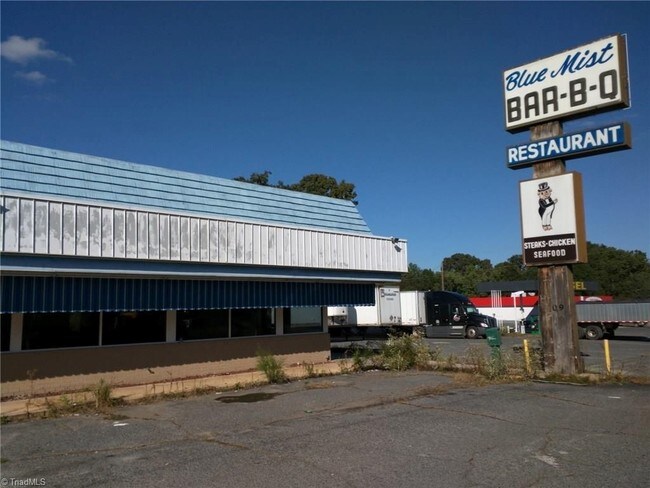
3409 Us Highway 64 E
7771-99-8739
Charles T & Peggy C Trogdon
Storebuilding
R64;N PL:UNREC-2016
X
Randolph
3710777100J
North Carolina
2025
5.13 AC
2025
SE Randolph County
030806
Greensboro/Winston-Salem
9,838 SF
Greensboro-High Point, NC
DEMOGRAPHICS near 3409 Us Highway 64 E
1 Mile
3 Mile
5 Mile
2024 Total Population
783
6,754
36,665
2029 Population
818
7,058
38,201
Pop Growth 2024-2029
+ 4.47%
+ 4.50%
+ 4.19%
Average Age
39
39
39
2024 Total Households
308
2,539
14,411
HH Growth 2024-2029
+ 4.22%
+ 4.49%
+ 4.15%
Median Household Inc
$42,500
$41,419
$47,810
Avg Household Size
2.50
2.60
2.50
2024 Avg HH Vehicles
2.00
2.00
2.00
Median Home Value
$124,138
$132,479
$136,333
Median Year Built
1991
1988
1980
Nearby Places
Map Layers
Map Styles
 Street
 Aerial
- Restaurants
- Banks
- Shops
- Fitness
- Groceries
PUBLIC TRANSPORTATION
AIRPORT
Piedmont Triad International
DRIVE
WALK
Distance
Piedmont Triad International
52 min
37.1 mi
Freight Ports
Port of Wilmington
DRIVE
WALK
Distance
Port of Wilmington
230 min
194.6 mi
SALE & LEASE HISTORY
LISTING DATE
SALE/LEASE

Sep 24, 2016
For Sale
Nearby Properties
Address
Land Use
TOTAL SIZE
Lot Size
Zoning
Address
Land Use
TOTAL SIZE
Lot Size
Zoning
178,413 SF
36.13 AC
B2
Address
Land Use
TOTAL SIZE
Lot Size
Zoning
178,413 SF
35.87 AC
B2
Address
Land Use
TOTAL SIZE
Lot Size
Zoning
29,212 SF
104.58 AC
B2
Address
Land Use
TOTAL SIZE
Lot Size
Zoning
83,900 SF
8.22 AC
B2
Address
Land Use
TOTAL SIZE
Lot Size
Zoning
38,113 SF
8.56 AC
B2
Address
Land Use
TOTAL SIZE
Lot Size
Zoning
38,113 SF
8.16 AC
B2
Address
Land Use
TOTAL SIZE
Lot Size
Zoning
53,871 SF
11.36 AC
B2
Address
Land Use
TOTAL SIZE
Lot Size
Zoning
89,012 SF
74.39 AC
RA
Address
Land Use
TOTAL SIZE
Lot Size
Zoning
14,800 SF
6.03 AC
I1
Address
Land Use
TOTAL SIZE
Lot Size
Zoning
25,492 SF
16.98 AC
B2
Address
Land Use
TOTAL SIZE
Lot Size
Zoning
7,870 SF
3.81 AC
B2
Address
Land Use
TOTAL SIZE
Lot Size
Zoning
20,149 SF
4.11 AC
B2
Address
Land Use
TOTAL SIZE
Lot Size
Zoning
19,267 SF
3.60 AC
B2
Address
Land Use
TOTAL SIZE
Lot Size
Zoning
9,476 SF
44.39 AC
B2
Address
Land Use
TOTAL SIZE
Lot Size
Zoning
23,946 SF
5.51 AC
B2
Address
Land Use
TOTAL SIZE
Lot Size
Zoning
59,174 SF
13.07 AC
LI
Address
Land Use
TOTAL SIZE
Lot Size
Zoning
7,611 SF
1.35 AC
B2
Address
Land Use
TOTAL SIZE
Lot Size
Zoning
9,440 SF
3.62 AC
RA6
Address
Land Use
TOTAL SIZE
Lot Size
Zoning
3,750 SF
60.29 AC
RA
Address
Land Use
TOTAL SIZE
Lot Size
Zoning
21,140 SF
12.84 AC
I2
Address
Land Use
TOTAL SIZE
Lot Size
Zoning
33,699 SF
15.01 AC
HC
Address
Land Use
TOTAL SIZE
Lot Size
Zoning
19,800 SF
21.90 AC
HC-CD
Address
Land Use
TOTAL SIZE
Lot Size
Zoning
2,800 SF
238.08 AC
RA
Address
Land Use
TOTAL SIZE
Lot Size
Zoning
11,920 SF
1.05 AC
B2
Address
Land Use
TOTAL SIZE
Lot Size
Zoning
3,428 SF
0.94 AC
B2
Address
Land Use
TOTAL SIZE
Lot Size
Zoning
12,240 SF
1.08 AC
B2
Address
Land Use
TOTAL SIZE
Lot Size
Zoning
8,594 SF
4.94 AC
HC
Address
Land Use
TOTAL SIZE
Lot Size
Zoning
21,200 SF
11.92 AC
LI
Address
Land Use
TOTAL SIZE
Lot Size
Zoning
4,800 SF
12.40 AC
RA
Address
Land Use
TOTAL SIZE
Lot Size
Zoning
9.02 AC
B2
The World's #1 Commercial Real Estate Marketplace
Connect with us
© 2025 CoStar Group
The information above has been obtained from sources believed reliable. While we do not doubt its accuracy we have not verified it and make no guarantee, warranty or representation about it. It is your responsibility to independently confirm its accuracy and completeness. Any projections, opinions, assumptions, or estimates used are for example only and do not represent the current or future performance of the property. The value of this transaction to you depends on tax and other factors which should be evaluated by your tax, financial, and legal advisors. You and your advisors should conduct a careful, independent investigation of the property to determine to your satisfaction the suitability of the property for your needs.