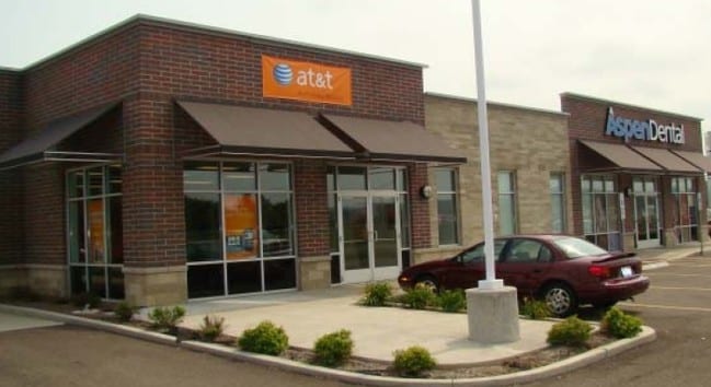
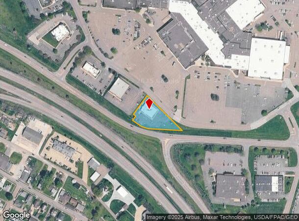
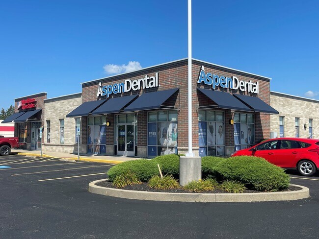
Property Record
341 Graff Rd Se, New Philadelphia, OH 44663
NEARBY LISTINGS FOR SALE OR LEASE
-
-
No Photo
-
-
View all New Philadelphia listings for sale on LoopNet.com
Property Detail
341 Graff Rd Se
4307587005
2 8 1 OL 155-156 .724A
Commercialnec
Tuscarawas
X
Ohio
39157C0255D
155
2024
0.72 AC
2024
Ohio North Area
021501
Other Market Areas
4,786 SF
New Philadelphia-Dover, OH
DEMOGRAPHICS near 341 Graff Rd Se
1 Mile
3 Mile
5 Mile
2024 Total Population
7,342
24,029
39,111
2029 Population
7,297
23,909
38,829
Pop Growth 2024-2029
(0.61%)
(0.50%)
(0.72%)
Average Age
42
42
42
2024 Total Households
3,180
10,275
16,170
HH Growth 2024-2029
(0.69%)
(0.57%)
(0.80%)
Median Household Inc
$43,181
$51,188
$53,984
Avg Household Size
2.20
2.20
2.30
2024 Avg HH Vehicles
2.00
2.00
2.00
Median Home Value
$135,493
$157,641
$162,497
Median Year Built
1971
1965
1964
Nearby Places
Map Layers
Map Styles
 Street
 Aerial
- Restaurants
- Banks
- Shops
- Fitness
- Groceries
SALE & LEASE HISTORY
LISTING DATE
SALE/LEASE

Sep 07, 2023
For Sale
Dec 27, 2023
For Sale
Nearby Properties
Address
Land Use
TOTAL SIZE
Lot Size
Zoning
Address
Land Use
TOTAL SIZE
Lot Size
Zoning
321,690 SF
50 AC
Address
Land Use
TOTAL SIZE
Lot Size
Zoning
71,013 SF
11.82 AC
Address
Land Use
TOTAL SIZE
Lot Size
Zoning
432,396 SF
39.33 AC
Address
Land Use
TOTAL SIZE
Lot Size
Zoning
33,685 SF
13.89 AC
Address
Land Use
TOTAL SIZE
Lot Size
Zoning
14,227 SF
10 AC
Address
Land Use
TOTAL SIZE
Lot Size
Zoning
11,806 SF
0.53 AC
Address
Land Use
TOTAL SIZE
Lot Size
Zoning
23,528 SF
1.25 AC
Address
Land Use
TOTAL SIZE
Lot Size
Zoning
23,632 SF
2.66 AC
Address
Land Use
TOTAL SIZE
Lot Size
Zoning
28,902 SF
1.61 AC
Address
Land Use
TOTAL SIZE
Lot Size
Zoning
50,661 SF
28.95 AC
Address
Land Use
TOTAL SIZE
Lot Size
Zoning
35,434 SF
1.76 AC
Address
Land Use
TOTAL SIZE
Lot Size
Zoning
4,477 SF
0.63 AC
Address
Land Use
TOTAL SIZE
Lot Size
Zoning
35,828 SF
4.16 AC
Address
Land Use
TOTAL SIZE
Lot Size
Zoning
20,000 SF
1.08 AC
Address
Land Use
TOTAL SIZE
Lot Size
Zoning
50,400 SF
3.58 AC
Address
Land Use
TOTAL SIZE
Lot Size
Zoning
18,952 SF
0.50 AC
Address
Land Use
TOTAL SIZE
Lot Size
Zoning
12,708 SF
0.36 AC
Address
Land Use
TOTAL SIZE
Lot Size
Zoning
27,968 SF
4 AC
Address
Land Use
TOTAL SIZE
Lot Size
Zoning
2,570 SF
156.19 AC
Address
Land Use
TOTAL SIZE
Lot Size
Zoning
11,986 SF
1.48 AC
Address
Land Use
TOTAL SIZE
Lot Size
Zoning
64,564 SF
5.18 AC
Address
Land Use
TOTAL SIZE
Lot Size
Zoning
11,126 SF
1.66 AC
Address
Land Use
TOTAL SIZE
Lot Size
Zoning
29,130 SF
9.57 AC
Address
Land Use
TOTAL SIZE
Lot Size
Zoning
13,659 SF
0.96 AC
Address
Land Use
TOTAL SIZE
Lot Size
Zoning
38,076 SF
2.57 AC
Address
Land Use
TOTAL SIZE
Lot Size
Zoning
8,770 SF
32.51 AC
Address
Land Use
TOTAL SIZE
Lot Size
Zoning
15,088 SF
91.33 AC
Address
Land Use
TOTAL SIZE
Lot Size
Zoning
15,340 SF
51.66 AC
Address
Land Use
TOTAL SIZE
Lot Size
Zoning
8,281 SF
2.35 AC
The World's #1 Commercial Real Estate Marketplace
Connect with us
© 2026 CoStar Group
The information above has been obtained from sources believed reliable. While we do not doubt its accuracy we have not verified it and make no guarantee, warranty or representation about it. It is your responsibility to independently confirm its accuracy and completeness. Any projections, opinions, assumptions, or estimates used are for example only and do not represent the current or future performance of the property. The value of this transaction to you depends on tax and other factors which should be evaluated by your tax, financial, and legal advisors. You and your advisors should conduct a careful, independent investigation of the property to determine to your satisfaction the suitability of the property for your needs.