Property Record
341 Mosher Rd, Gorham, ME 04038
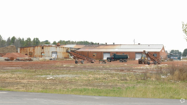

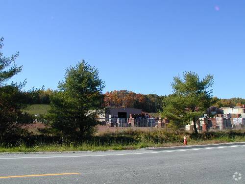
Property Detail
341 Mosher Rd
Industrialgeneral
CUMBERLAND
I
Maine
B and X Area of moderate flood hazard, usually the area between the limits of the 100-year and 500-year floods.
12.19 AC
2025
SW Cumberland County
2025
Portland/South Portland
004001
Portland-South Portland, ME
43,822 SF
GRHM-000034-000009
NEARBY LISTINGS FOR SALE OR LEASE
DEMOGRAPHICS near 341 Mosher Rd
1 mile
3 mile
5 mile
2025 Total Population
433
24,724
49,017
2030 Population
448
25,943
50,779
Pop Growth 2025-2030
+ 3.46%
+ 4.93%
+ 3.59%
Average Age
40
39
40
2025 Total Households
151
9,329
19,039
HH Growth 2025-2030
+ 3.31%
+ 4.98%
+ 3.63%
Median Household Inc
$114,087
$112,247
$106,751
Avg Household Size
2.80
2.40
2.40
2025 Avg HH Vehicles
2.00
2.00
2.00
Median Home Value
$466,911
$468,283
$445,043
Median Year Built
1995
1985
1981
Nearby Places
Map Layers
Map Styles
 Street
 Aerial
Transit
 Traffic
 Biking
Places
Listings with unknown addresses are not visible on the map
- Restaurants
- Banks
- Shops
- Fitness
- Groceries
PUBLIC TRANSPORTATION
COMMUTER RAIL
Portland (Downeaster - Amtrak)
Drive
Walk
Distance
Portland (Downeaster - Amtrak)
17 min
8.2 mi
AIRPORT
Portland International Jetport
Drive
Walk
Distance
Portland International Jetport
18 min
7.6 mi
Freight Ports
Portland, ME
Drive
Walk
Distance
Portland, ME
20 min
10.9 mi
Nearby Properties
Address
Land Use
TOTAL SIZE
Lot Size
Zoning
Address
Land Use
TOTAL SIZE
Lot Size
Zoning
10.08 AC
Address
Land Use
TOTAL SIZE
Lot Size
Zoning
13.20 AC
I
Address
Land Use
TOTAL SIZE
Lot Size
Zoning
55.70 AC
14
Address
Land Use
TOTAL SIZE
Lot Size
Zoning
19.46 AC
UR
Address
Land Use
TOTAL SIZE
Lot Size
Zoning
139,588 SF
0.85 AC
16
Address
Land Use
TOTAL SIZE
Lot Size
Zoning
93,041 SF
5.53 AC
UR
Address
Land Use
TOTAL SIZE
Lot Size
Zoning
59,965 SF
27.72 AC
R
Address
Land Use
TOTAL SIZE
Lot Size
Zoning
148,964 SF
35.12 AC
UR
Address
Land Use
TOTAL SIZE
Lot Size
Zoning
7,860 SF
3.07 AC
UC
Address
Land Use
TOTAL SIZE
Lot Size
Zoning
79.65 AC
UR
Address
Land Use
TOTAL SIZE
Lot Size
Zoning
3.44 AC
27
Address
Land Use
TOTAL SIZE
Lot Size
Zoning
83,135 SF
7.23 AC
11
Address
Land Use
TOTAL SIZE
Lot Size
Zoning
25.14 AC
I
Address
Land Use
TOTAL SIZE
Lot Size
Zoning
60,869 SF
17.96 AC
UR
Address
Land Use
TOTAL SIZE
Lot Size
Zoning
97,200 SF
12.50 AC
12
Address
Land Use
TOTAL SIZE
Lot Size
Zoning
9.12 AC
11
Address
Land Use
TOTAL SIZE
Lot Size
Zoning
46,764 SF
4.64 AC
UC
Address
Land Use
TOTAL SIZE
Lot Size
Zoning
Address
Land Use
TOTAL SIZE
Lot Size
Zoning
13.07 AC
11
Address
Land Use
TOTAL SIZE
Lot Size
Zoning
171,000 SF
1.47 AC
16
Address
Land Use
TOTAL SIZE
Lot Size
Zoning
183,784 SF
7.20 AC
17
Address
Land Use
TOTAL SIZE
Lot Size
Zoning
114,224 SF
3.48 AC
16
Address
Land Use
TOTAL SIZE
Lot Size
Zoning
14.78 AC
I
Address
Land Use
TOTAL SIZE
Lot Size
Zoning
107,540 SF
18.50 AC
I
Address
Land Use
TOTAL SIZE
Lot Size
Zoning
67,344 SF
0.60 AC
Address
Land Use
TOTAL SIZE
Lot Size
Zoning
1.79 AC
14
Address
Land Use
TOTAL SIZE
Lot Size
Zoning
14.05 AC
17
Address
Land Use
TOTAL SIZE
Lot Size
Zoning
3.66 AC
11
Address
Land Use
TOTAL SIZE
Lot Size
Zoning
35,845 SF
5.01 AC
UR
Address
Land Use
TOTAL SIZE
Lot Size
Zoning
33,180 SF
7.95 AC
I
The World's #1 Commercial Real Estate Marketplace
Connect with us
© 2026 CoStar Group
The information above has been obtained from sources believed reliable. While we do not doubt its accuracy we have not verified it and make no guarantee, warranty or representation about it. It is your responsibility to independently confirm its accuracy and completeness. Any projections, opinions, assumptions, or estimates used are for example only and do not represent the current or future performance of the property. The value of this transaction to you depends on tax and other factors which should be evaluated by your tax, financial, and legal advisors. You and your advisors should conduct a careful, independent investigation of the property to determine to your satisfaction the suitability of the property for your needs.