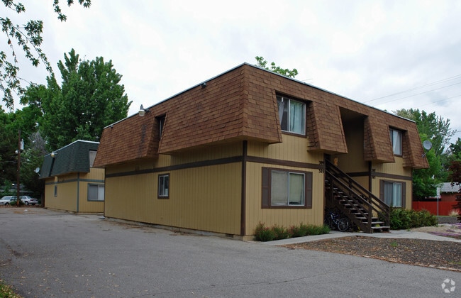
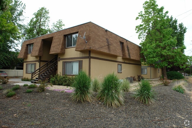
Property Record
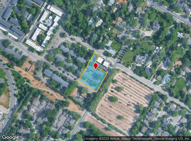
341 S Walnut St, Boise, ID 83712
NEARBY LISTINGS FOR SALE OR LEASE
Property Detail
341 S Walnut St
S1011347060
PAR #7060 OF SW4 SEC 11 3N 2E
Commercialbuilding
Ada
X
Idaho
16001C0281J
0.97 AC
2024
East End
2025
Boise City/Nampa
000701
Boise City, ID
19,680 SF
DEMOGRAPHICS near 341 S Walnut St
1 Mile
3 Mile
5 Mile
2024 Total Population
13,762
89,958
157,930
2029 Population
15,792
102,304
179,230
Pop Growth 2024-2029
+ 14.75%
+ 13.72%
+ 13.49%
Average Age
38
39
39
2024 Total Households
6,868
40,958
69,127
HH Growth 2024-2029
+ 15.36%
+ 14.19%
+ 13.89%
Median Household Inc
$70,174
$66,855
$67,390
Avg Household Size
1.90
2.10
2.20
2024 Avg HH Vehicles
2.00
2.00
2.00
Median Home Value
$649,779
$514,029
$484,124
Median Year Built
1986
1980
1982
Nearby Places
Map Layers
Map Styles
 Street
 Aerial
- Restaurants
- Banks
- Shops
- Fitness
- Groceries
PUBLIC TRANSPORTATION
AIRPORT
Boise Air Trml/Gowen Field
DRIVE
WALK
Distance
Boise Air Trml/Gowen Field
25 min
9.3 mi
Freight Ports
Port of Portland
DRIVE
WALK
Distance
Port of Portland
481 min
434.3 mi
Nearby Properties
Address
Land Use
TOTAL SIZE
Lot Size
Zoning
Address
Land Use
TOTAL SIZE
Lot Size
Zoning
369,584 SF
1 AC
ZC-259
Address
Land Use
TOTAL SIZE
Lot Size
Zoning
635,403 SF
23.42 AC
ZC-243
Address
Land Use
TOTAL SIZE
Lot Size
Zoning
434,370 SF
0.56 AC
ZC-259
Address
Land Use
TOTAL SIZE
Lot Size
Zoning
129,663 SF
0.92 AC
ZC-259
Address
Land Use
TOTAL SIZE
Lot Size
Zoning
240,481 SF
1.79 AC
ZC-264
Address
Land Use
TOTAL SIZE
Lot Size
Zoning
251,614 SF
12.62 AC
ZC-245
Address
Land Use
TOTAL SIZE
Lot Size
Zoning
13.90 AC
R-2
Address
Land Use
TOTAL SIZE
Lot Size
Zoning
279,694 SF
2.09 AC
ZC-264
Address
Land Use
TOTAL SIZE
Lot Size
Zoning
258,747 SF
3.30 AC
ZC-266
Address
Land Use
TOTAL SIZE
Lot Size
Zoning
413,253 SF
3.33 AC
ZC-260
Address
Land Use
TOTAL SIZE
Lot Size
Zoning
402,504 SF
5.78 AC
ZC-259
Address
Land Use
TOTAL SIZE
Lot Size
Zoning
334,334 SF
3.21 AC
ZC-259
Address
Land Use
TOTAL SIZE
Lot Size
Zoning
156,000 SF
4.57 AC
ZC-241
Address
Land Use
TOTAL SIZE
Lot Size
Zoning
197,268 SF
10.95 AC
R-3
Address
Land Use
TOTAL SIZE
Lot Size
Zoning
204,396 SF
0.82 AC
ZC-261
Address
Land Use
TOTAL SIZE
Lot Size
Zoning
203,503 SF
7.93 AC
ZC-243
Address
Land Use
TOTAL SIZE
Lot Size
Zoning
366,126 SF
0.82 AC
ZC-259
Address
Land Use
TOTAL SIZE
Lot Size
Zoning
223,171 SF
0.85 AC
ZC-264
Address
Land Use
TOTAL SIZE
Lot Size
Zoning
214,318 SF
13.77 AC
R-2
Address
Land Use
TOTAL SIZE
Lot Size
Zoning
359,820 SF
1.79 AC
ZC-259
Address
Land Use
TOTAL SIZE
Lot Size
Zoning
459,218 SF
1.79 AC
ZC-241
Address
Land Use
TOTAL SIZE
Lot Size
Zoning
159,859 SF
0.80 AC
ZC-264
Address
Land Use
TOTAL SIZE
Lot Size
Zoning
259,565 SF
4.07 AC
SP-02
Address
Land Use
TOTAL SIZE
Lot Size
Zoning
10.03 AC
R-3
Address
Land Use
TOTAL SIZE
Lot Size
Zoning
205,522 SF
0.82 AC
ZC-259
Address
Land Use
TOTAL SIZE
Lot Size
Zoning
276,099 SF
8.70 AC
ZC-261
Address
Land Use
TOTAL SIZE
Lot Size
Zoning
157,347 SF
7.97 AC
R-3
Address
Land Use
TOTAL SIZE
Lot Size
Zoning
216,371 SF
0.78 AC
ZC-261
Address
Land Use
TOTAL SIZE
Lot Size
Zoning
189,100 SF
0.60 AC
ZC-259
Address
Land Use
TOTAL SIZE
Lot Size
Zoning
182,950 SF
0.41 AC
ZC-259
The World's #1 Commercial Real Estate Marketplace
Connect with us
© 2026 CoStar Group
The information above has been obtained from sources believed reliable. While we do not doubt its accuracy we have not verified it and make no guarantee, warranty or representation about it. It is your responsibility to independently confirm its accuracy and completeness. Any projections, opinions, assumptions, or estimates used are for example only and do not represent the current or future performance of the property. The value of this transaction to you depends on tax and other factors which should be evaluated by your tax, financial, and legal advisors. You and your advisors should conduct a careful, independent investigation of the property to determine to your satisfaction the suitability of the property for your needs.