Property Record
341 Snowden Bridge Blvd, Stephenson, VA 22656
NEARBY LISTINGS FOR SALE OR LEASE
Property Detail
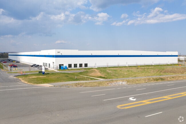
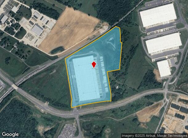
341 Snowden Bridge Blvd
44A-26B
LOT 3 26.40 ACRES
Multipleuses
Frederick
X
Virginia
54037C0200E
3
2025
26.40 AC
2025
Frederick County VA
050100
Washington, DC
348,500 SF
Winchester, VA-WV
DEMOGRAPHICS near 341 Snowden Bridge Blvd
1 Mile
3 Mile
5 Mile
2024 Total Population
743
30,440
60,855
2029 Population
837
32,631
64,617
Pop Growth 2024-2029
+ 12.65%
+ 7.20%
+ 6.18%
Average Age
37
38
40
2024 Total Households
262
11,113
22,889
HH Growth 2024-2029
+ 12.60%
+ 6.96%
+ 5.87%
Median Household Inc
$77,989
$70,318
$75,217
Avg Household Size
2.80
2.60
2.50
2024 Avg HH Vehicles
2.00
2.00
2.00
Median Home Value
$264,150
$262,081
$308,893
Median Year Built
2009
1986
1985
Nearby Places
Map Layers
Map Styles
 Street
 Aerial
- Restaurants
- Banks
- Shops
- Fitness
- Groceries
SALE & LEASE HISTORY
LISTING DATE
SALE/LEASE

Dec 05, 2018
For Lease
Nearby Properties
Address
Land Use
TOTAL SIZE
Lot Size
Zoning
Address
Land Use
TOTAL SIZE
Lot Size
Zoning
79,038 SF
128.48 AC
RA
Address
Land Use
TOTAL SIZE
Lot Size
Zoning
40,820 SF
31.78 AC
M1
Address
Land Use
TOTAL SIZE
Lot Size
Zoning
465,856 SF
43.50 AC
M1
Address
Land Use
TOTAL SIZE
Lot Size
Zoning
400,400 SF
27.18 AC
M1
Address
Land Use
TOTAL SIZE
Lot Size
Zoning
161,923 SF
17.10 AC
M1
Address
Land Use
TOTAL SIZE
Lot Size
Zoning
331,925 SF
21.17 AC
M1
Address
Land Use
TOTAL SIZE
Lot Size
Zoning
330,050 SF
25.05 AC
M1
Address
Land Use
TOTAL SIZE
Lot Size
Zoning
423,360 SF
24.23 AC
M1
Address
Land Use
TOTAL SIZE
Lot Size
Zoning
287,000 SF
19.29 AC
M1
Address
Land Use
TOTAL SIZE
Lot Size
Zoning
325,000 SF
18.09 AC
M1
Address
Land Use
TOTAL SIZE
Lot Size
Zoning
300,000 SF
29.04 AC
M1
Address
Land Use
TOTAL SIZE
Lot Size
Zoning
347,200 SF
25.50 AC
M1
Address
Land Use
TOTAL SIZE
Lot Size
Zoning
1,530 SF
14.10 AC
RP
Address
Land Use
TOTAL SIZE
Lot Size
Zoning
56,746 SF
30 AC
M1
Address
Land Use
TOTAL SIZE
Lot Size
Zoning
84,375 SF
20 AC
R4
Address
Land Use
TOTAL SIZE
Lot Size
Zoning
80,744 SF
21.41 AC
B2
Address
Land Use
TOTAL SIZE
Lot Size
Zoning
257,491 SF
24.40 AC
M1
Address
Land Use
TOTAL SIZE
Lot Size
Zoning
209,560 SF
18.59 AC
M1
Address
Land Use
TOTAL SIZE
Lot Size
Zoning
76,936 SF
10 AC
RA
Address
Land Use
TOTAL SIZE
Lot Size
Zoning
91,468 SF
7.37 AC
EIP
Address
Land Use
TOTAL SIZE
Lot Size
Zoning
69,975 SF
14.77 AC
B2
Address
Land Use
TOTAL SIZE
Lot Size
Zoning
67,200 SF
16.89 AC
M1
Address
Land Use
TOTAL SIZE
Lot Size
Zoning
142,200 SF
12.88 AC
B2
Address
Land Use
TOTAL SIZE
Lot Size
Zoning
164,530 SF
39.29 AC
M1
Address
Land Use
TOTAL SIZE
Lot Size
Zoning
52,640 SF
11.62 AC
M1
Address
Land Use
TOTAL SIZE
Lot Size
Zoning
175,500 SF
17.40 AC
M1
Address
Land Use
TOTAL SIZE
Lot Size
Zoning
90,000 SF
14.12 AC
M1
Address
Land Use
TOTAL SIZE
Lot Size
Zoning
242,931 SF
23.53 AC
M1
Address
Land Use
TOTAL SIZE
Lot Size
Zoning
201,904 SF
10.95 AC
M1
The World's #1 Commercial Real Estate Marketplace
Connect with us
© 2025 CoStar Group
The information above has been obtained from sources believed reliable. While we do not doubt its accuracy we have not verified it and make no guarantee, warranty or representation about it. It is your responsibility to independently confirm its accuracy and completeness. Any projections, opinions, assumptions, or estimates used are for example only and do not represent the current or future performance of the property. The value of this transaction to you depends on tax and other factors which should be evaluated by your tax, financial, and legal advisors. You and your advisors should conduct a careful, independent investigation of the property to determine to your satisfaction the suitability of the property for your needs.