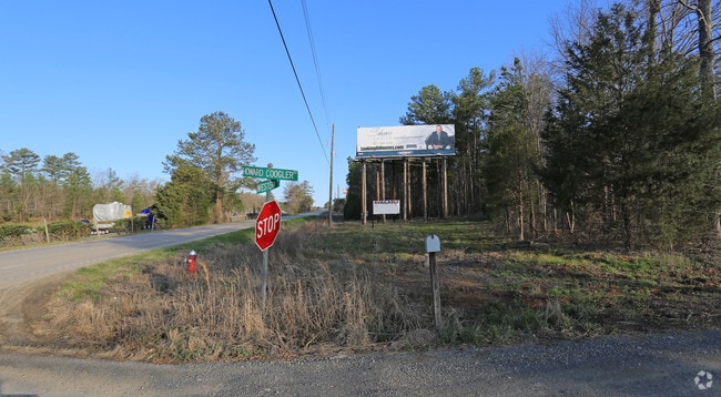
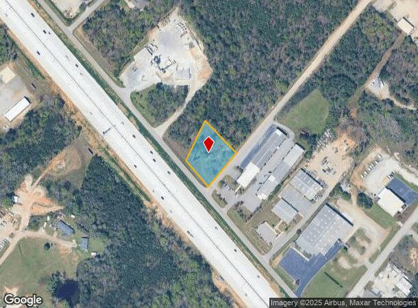
Property Record
341 Western Ln, Irmo, SC 29063
NEARBY LISTINGS FOR SALE OR LEASE
Property Detail
341 Western Ln
Columbia, SC
Irmo Whiterock Ballentine
04000-03-03
PARCEL A 163.9X208.7X208.7X208.7 #SU #PR 44-143
Commercialnec
Richland
X
South Carolina
45063C0127J
0.86 AC
2025
Dutch Fork/Irmo
2023
Columbia
010308
DEMOGRAPHICS near 341 Western Ln
1 mile
3 mile
5 mile
2024 Total Population
4,046
39,942
70,371
2029 Population
4,060
41,072
72,888
Pop Growth 2024-2029
+ 0.35%
+ 2.83%
+ 3.58%
Average Age
39
40
41
2024 Total Households
1,588
15,711
28,447
HH Growth 2024-2029
+ 0.31%
+ 3.02%
+ 3.79%
Median Household Inc
$68,686
$84,422
$80,102
Avg Household Size
2.50
2.50
2.40
2024 Avg HH Vehicles
2.00
2.00
2.00
Median Home Value
$152,681
$209,446
$211,480
Median Year Built
1986
1992
1990
Nearby Places
Map Layers
Map Styles
 Street
 Aerial
Transit
 Traffic
 Biking
Places
Listings with unknown addresses are not visible on the map
- Restaurants
- Banks
- Shops
- Fitness
- Groceries
PUBLIC TRANSPORTATION
AIRPORT
Columbia Metro
Drive
Walk
Distance
Columbia Metro
36 min
18.3 mi
SALE & LEASE HISTORY
LISTING DATE
SALE/LEASE

Sep 24, 2016
For Sale
Mar 22, 2019
For Sale
Apr 20, 2017
For Sale
Nearby Properties
Address
Land Use
TOTAL SIZE
Lot Size
Zoning
Address
Land Use
TOTAL SIZE
Lot Size
Zoning
24.90 AC
PD
Address
Land Use
TOTAL SIZE
Lot Size
Zoning
370,876 SF
14.43 AC
PD
Address
Land Use
TOTAL SIZE
Lot Size
Zoning
241,756 SF
14.25 AC
PD
Address
Land Use
TOTAL SIZE
Lot Size
Zoning
215,796 SF
12.71 AC
PD
Address
Land Use
TOTAL SIZE
Lot Size
Zoning
191,009 SF
28.02 AC
CG
Address
Land Use
TOTAL SIZE
Lot Size
Zoning
86,542 SF
3.25 AC
PD
Address
Land Use
TOTAL SIZE
Lot Size
Zoning
88,284 SF
0.78 AC
PD
Address
Land Use
TOTAL SIZE
Lot Size
Zoning
81,197 SF
10.34 AC
C-3
Address
Land Use
TOTAL SIZE
Lot Size
Zoning
153,210 SF
31.78 AC
LM
Address
Land Use
TOTAL SIZE
Lot Size
Zoning
32.33 AC
PD
Address
Land Use
TOTAL SIZE
Lot Size
Zoning
70,390 SF
12.76 AC
CAC
Address
Land Use
TOTAL SIZE
Lot Size
Zoning
77,644 SF
2.59 AC
PD
Address
Land Use
TOTAL SIZE
Lot Size
Zoning
75,358 SF
13.84 AC
M-1
Address
Land Use
TOTAL SIZE
Lot Size
Zoning
66,351 SF
2.20 AC
PD
Address
Land Use
TOTAL SIZE
Lot Size
Zoning
8,358 SF
9.12 AC
CG
Address
Land Use
TOTAL SIZE
Lot Size
Zoning
243,045 SF
12.97 AC
PD
Address
Land Use
TOTAL SIZE
Lot Size
Zoning
76,204 SF
2.26 AC
CN
Address
Land Use
TOTAL SIZE
Lot Size
Zoning
21,580 SF
16.15 AC
GC
Address
Land Use
TOTAL SIZE
Lot Size
Zoning
66,612 SF
5.56 AC
CG
Address
Land Use
TOTAL SIZE
Lot Size
Zoning
54,842 SF
1.73 AC
PD
Address
Land Use
TOTAL SIZE
Lot Size
Zoning
23,907 SF
14 AC
PD
Address
Land Use
TOTAL SIZE
Lot Size
Zoning
85,201 SF
48.22 AC
CG
Address
Land Use
TOTAL SIZE
Lot Size
Zoning
13.81 AC
M-1
Address
Land Use
TOTAL SIZE
Lot Size
Zoning
49,840 SF
2.25 AC
CG
Address
Land Use
TOTAL SIZE
Lot Size
Zoning
7.81 AC
PD
Address
Land Use
TOTAL SIZE
Lot Size
Zoning
67,864 SF
3.94 AC
CG
Address
Land Use
TOTAL SIZE
Lot Size
Zoning
54,544 SF
5.71 AC
CAC
Address
Land Use
TOTAL SIZE
Lot Size
Zoning
95,450 SF
3.68 AC
PDD
Address
Land Use
TOTAL SIZE
Lot Size
Zoning
56,958 SF
6.21 AC
CG
Address
Land Use
TOTAL SIZE
Lot Size
Zoning
9.83 AC
CG
The World's #1 Commercial Real Estate Marketplace
Connect with us
© 2026 CoStar Group
The information above has been obtained from sources believed reliable. While we do not doubt its accuracy we have not verified it and make no guarantee, warranty or representation about it. It is your responsibility to independently confirm its accuracy and completeness. Any projections, opinions, assumptions, or estimates used are for example only and do not represent the current or future performance of the property. The value of this transaction to you depends on tax and other factors which should be evaluated by your tax, financial, and legal advisors. You and your advisors should conduct a careful, independent investigation of the property to determine to your satisfaction the suitability of the property for your needs.