Property Record
3410 E Highway 34 E, Sharpsburg, GA 30277

NEARBY LISTINGS FOR SALE OR LEASE
-
-
View all Sharpsburg listings for sale on LoopNet.com
Property Detail
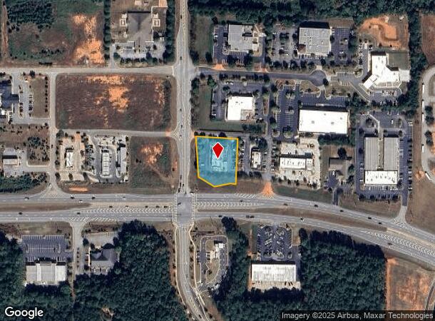
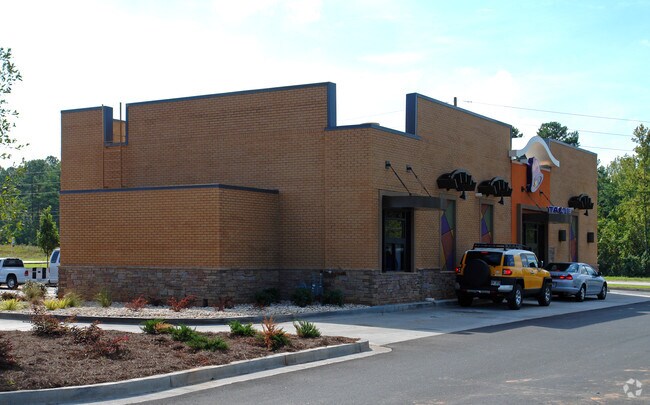
3410 E Highway 34 E
Atlanta-Sandy Springs-Roswell, GA
Thomas Grace Anx
121-6070-004
TACO BELL/.872 ACS LL 70 6LD
Restaurantdrivein
Coweta
X
Georgia
13077C0170D
70
2025
0.87 AC
2025
Coweta County
170404
Atlanta
2,880 SF
DEMOGRAPHICS near 3410 E Highway 34 E
1 Mile
3 Mile
5 Mile
2024 Total Population
2,703
21,850
66,395
2029 Population
3,015
24,215
72,871
Pop Growth 2024-2029
+ 11.54%
+ 10.82%
+ 9.75%
Average Age
43
42
41
2024 Total Households
978
7,786
24,364
HH Growth 2024-2029
+ 11.66%
+ 10.93%
+ 9.81%
Median Household Inc
$99,999
$109,182
$101,547
Avg Household Size
2.70
2.80
2.70
2024 Avg HH Vehicles
3.00
3.00
2.00
Median Home Value
$272,612
$281,768
$309,264
Median Year Built
1993
1995
1997
Nearby Places
Map Layers
Map Styles
 Street
 Aerial
- Restaurants
- Banks
- Shops
- Fitness
- Groceries
PUBLIC TRANSPORTATION
AIRPORT
Hartsfield - Jackson Atlanta International
DRIVE
WALK
Distance
Hartsfield - Jackson Atlanta International
37 min
27.5 mi
Nearby Properties
Address
Land Use
TOTAL SIZE
Lot Size
Zoning
Address
Land Use
TOTAL SIZE
Lot Size
Zoning
117,354 SF
48.81 AC
ND
Address
Land Use
TOTAL SIZE
Lot Size
Zoning
134,417 SF
13.01 AC
R1
Address
Land Use
TOTAL SIZE
Lot Size
Zoning
216,250 SF
20.12 AC
R1
Address
Land Use
TOTAL SIZE
Lot Size
Zoning
108,138 SF
6.36 AC
002
Address
Land Use
TOTAL SIZE
Lot Size
Zoning
71,888 SF
23.48 AC
R1
Address
Land Use
TOTAL SIZE
Lot Size
Zoning
70,162 SF
12.32 AC
001
Address
Land Use
TOTAL SIZE
Lot Size
Zoning
47,598 SF
4.29 AC
C
Address
Land Use
TOTAL SIZE
Lot Size
Zoning
121,290 SF
11.74 AC
R1
Address
Land Use
TOTAL SIZE
Lot Size
Zoning
59,250 SF
8.77 AC
R1
Address
Land Use
TOTAL SIZE
Lot Size
Zoning
186,249 SF
17.99 AC
R1
Address
Land Use
TOTAL SIZE
Lot Size
Zoning
63,876 SF
9.58 AC
ND
Address
Land Use
TOTAL SIZE
Lot Size
Zoning
186,695 SF
29.47 AC
R1
Address
Land Use
TOTAL SIZE
Lot Size
Zoning
80,630 SF
1.25 AC
002
Address
Land Use
TOTAL SIZE
Lot Size
Zoning
112,650 SF
5.70 AC
002
Address
Land Use
TOTAL SIZE
Lot Size
Zoning
137,702 SF
17.39 AC
R1
Address
Land Use
TOTAL SIZE
Lot Size
Zoning
53,968 SF
3.33 AC
M
Address
Land Use
TOTAL SIZE
Lot Size
Zoning
90,474 SF
12.56 AC
C
Address
Land Use
TOTAL SIZE
Lot Size
Zoning
117,635 SF
20 AC
001
Address
Land Use
TOTAL SIZE
Lot Size
Zoning
28,753 SF
4.83 AC
R1
Address
Land Use
TOTAL SIZE
Lot Size
Zoning
25,372 SF
2.27 AC
001
Address
Land Use
TOTAL SIZE
Lot Size
Zoning
103,594 SF
18.83 AC
R1
Address
Land Use
TOTAL SIZE
Lot Size
Zoning
47,540 SF
6.33 AC
R1
Address
Land Use
TOTAL SIZE
Lot Size
Zoning
28,560 SF
10.91 AC
R1
Address
Land Use
TOTAL SIZE
Lot Size
Zoning
80,564 SF
16.23 AC
R1
Address
Land Use
TOTAL SIZE
Lot Size
Zoning
31,794 SF
2.65 AC
R1
Address
Land Use
TOTAL SIZE
Lot Size
Zoning
37.78 AC
002
Address
Land Use
TOTAL SIZE
Lot Size
Zoning
76,920 SF
6.40 AC
R1
Address
Land Use
TOTAL SIZE
Lot Size
Zoning
98,838 SF
8.18 AC
R1
Address
Land Use
TOTAL SIZE
Lot Size
Zoning
67,604 SF
29.71 AC
R1
Address
Land Use
TOTAL SIZE
Lot Size
Zoning
41,355 SF
25.21 AC
R1
The World's #1 Commercial Real Estate Marketplace
Connect with us
© 2025 CoStar Group
The information above has been obtained from sources believed reliable. While we do not doubt its accuracy we have not verified it and make no guarantee, warranty or representation about it. It is your responsibility to independently confirm its accuracy and completeness. Any projections, opinions, assumptions, or estimates used are for example only and do not represent the current or future performance of the property. The value of this transaction to you depends on tax and other factors which should be evaluated by your tax, financial, and legal advisors. You and your advisors should conduct a careful, independent investigation of the property to determine to your satisfaction the suitability of the property for your needs.