Property Record
3410 E Johnson Ave, Jonesboro, AR 72405
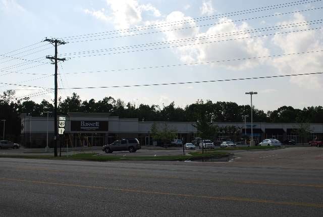

Property Detail
3410 E Johnson Ave
Jonesboro, AR
AMENDED PLAT OF QUINN HILLTOP 5TH REPLAT OF THE QUINN HILLTOP 4TH REPLAT & LOTS 9 AND 10 OF FW CALDWELL'S SUBDIVISION PT SW NW
01-144102-09900
CRAIGHEAD
Regionalshoppingcenterormallwithanchorstore
Arkansas
B and X Area of moderate flood hazard, usually the area between the limits of the 100-year and 500-year floods.
1
2024
6.78 AC
2025
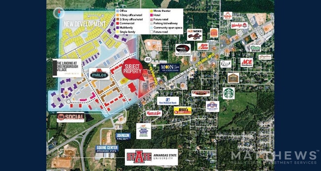
Downtown Jonesboro
000601
Other Market Areas
62,340 SF
NEARBY LISTINGS FOR SALE OR LEASE
DEMOGRAPHICS near 3410 E Johnson Ave
1 mile
3 mile
5 mile
2025 Total Population
3,585
36,477
68,432
2030 Population
3,756
38,079
71,253
Pop Growth 2025-2030
+ 4.77%
+ 4.39%
+ 4.12%
Average Age
35
35
37
2025 Total Households
1,480
14,003
27,396
HH Growth 2025-2030
+ 5.00%
+ 4.96%
+ 4.54%
Median Household Inc
$60,046
$41,269
$48,826
Avg Household Size
2.40
2.40
2.30
2025 Avg HH Vehicles
2.00
2.00
2.00
Median Home Value
$203,493
$186,706
$184,936
Median Year Built
2006
1994
1992
Nearby Places
Map Layers
Map Styles
 Street
 Aerial
Layers
 Traffic
 Biking
Places
Listings with unknown addresses are not visible on the map
- Restaurants
- Banks
- Shops
- Fitness
- Groceries
SALE & LEASE HISTORY
LISTING DATE
SALE/LEASE

Sep 25, 2016
For Lease
Oct 31, 2022
For Sale
Oct 30, 2018
For Lease
Apr 22, 2022
For Sale
Nearby Properties
Address
Land Use
TOTAL SIZE
Lot Size
Zoning
Address
Land Use
TOTAL SIZE
Lot Size
Zoning
217,426 SF
48.05 AC
Address
Land Use
TOTAL SIZE
Lot Size
Zoning
353,512 SF
15.01 AC
Address
Land Use
TOTAL SIZE
Lot Size
Zoning
45,783 SF
346.92 AC
Address
Land Use
TOTAL SIZE
Lot Size
Zoning
94,649 SF
18.69 AC
Address
Land Use
TOTAL SIZE
Lot Size
Zoning
61,868 SF
15.69 AC
Address
Land Use
TOTAL SIZE
Lot Size
Zoning
56,279 SF
8.37 AC
Address
Land Use
TOTAL SIZE
Lot Size
Zoning
219,080 SF
10.93 AC
Address
Land Use
TOTAL SIZE
Lot Size
Zoning
99,212 SF
7.49 AC
Address
Land Use
TOTAL SIZE
Lot Size
Zoning
120,208 SF
10.21 AC
Address
Land Use
TOTAL SIZE
Lot Size
Zoning
152,814 SF
13.62 AC
Address
Land Use
TOTAL SIZE
Lot Size
Zoning
Address
Land Use
TOTAL SIZE
Lot Size
Zoning
24,719 SF
24.88 AC
Address
Land Use
TOTAL SIZE
Lot Size
Zoning
65,020 SF
0.30 AC
Address
Land Use
TOTAL SIZE
Lot Size
Zoning
29,766 SF
2.41 AC
Address
Land Use
TOTAL SIZE
Lot Size
Zoning
62,735 SF
5.05 AC
Address
Land Use
TOTAL SIZE
Lot Size
Zoning
74,067 SF
8.71 AC
Address
Land Use
TOTAL SIZE
Lot Size
Zoning
47,512 SF
6.98 AC
Address
Land Use
TOTAL SIZE
Lot Size
Zoning
49,568 SF
14 AC
Address
Land Use
TOTAL SIZE
Lot Size
Zoning
69,840 SF
7.73 AC
Address
Land Use
TOTAL SIZE
Lot Size
Zoning
128,476 SF
10.91 AC
Address
Land Use
TOTAL SIZE
Lot Size
Zoning
74,690 SF
5.34 AC
Address
Land Use
TOTAL SIZE
Lot Size
Zoning
57,576 SF
2.06 AC
Address
Land Use
TOTAL SIZE
Lot Size
Zoning
51,612 SF
5.05 AC
Address
Land Use
TOTAL SIZE
Lot Size
Zoning
2,685 SF
3.05 AC
Address
Land Use
TOTAL SIZE
Lot Size
Zoning
14,830 SF
1.60 AC
Address
Land Use
TOTAL SIZE
Lot Size
Zoning
91,447 SF
3 AC
Address
Land Use
TOTAL SIZE
Lot Size
Zoning
108,337 SF
8.17 AC
Address
Land Use
TOTAL SIZE
Lot Size
Zoning
55,727 SF
2.29 AC
The World's #1 Commercial Real Estate Marketplace
Connect with us
© 2026 CoStar Group
The information above has been obtained from sources believed reliable. While we do not doubt its accuracy we have not verified it and make no guarantee, warranty or representation about it. It is your responsibility to independently confirm its accuracy and completeness. Any projections, opinions, assumptions, or estimates used are for example only and do not represent the current or future performance of the property. The value of this transaction to you depends on tax and other factors which should be evaluated by your tax, financial, and legal advisors. You and your advisors should conduct a careful, independent investigation of the property to determine to your satisfaction the suitability of the property for your needs.