Property Record
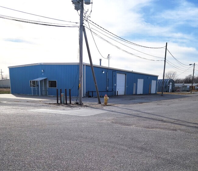
3410 Hancock St, Bellevue, NE 68005


Property Detail
3410 Hancock St
Omaha, NE-IA
LOT 5 HAYS ADDITION REPLAT I
011154780
Sarpy
Commercialnec
Nebraska
2024
5
2025
0.35 AC
010402
Sarpy East
5,120 SF
Omaha/Council Bluffs
NEARBY LISTINGS FOR SALE OR LEASE
-
-
View all Bellevue listings for lease on LoopNet.com
DEMOGRAPHICS near 3410 Hancock St
1 mile
3 mile
5 mile
2025 Total Population
4,160
25,553
65,657
2030 Population
4,425
27,120
69,801
Pop Growth 2025-2030
+ 6.37%
+ 6.13%
+ 6.31%
Average Age
38
39
37
2025 Total Households
1,738
10,502
25,159
HH Growth 2025-2030
+ 6.67%
+ 6.47%
+ 6.59%
Median Household Inc
$62,391
$73,815
$90,681
Avg Household Size
2.30
2.30
2.50
2025 Avg HH Vehicles
2.00
2.00
2.00
Median Home Value
$138,454
$236,140
$278,676
Median Year Built
1959
1974
1987
Nearby Places
Map Layers
Map Styles
 Street
 Aerial
Layers
 Traffic
 Biking
Places
Listings with unknown addresses are not visible on the map
- Restaurants
- Banks
- Shops
- Fitness
- Groceries
PUBLIC TRANSPORTATION
AIRPORT
Eppley Airfield
Drive
Walk
Distance
Eppley Airfield
29 min
16.3 mi
Freight Ports
Tulsa Port Of Catoosa
Drive
Walk
Distance
Tulsa Port Of Catoosa
451 min
407.0 mi
SALE & LEASE HISTORY
LISTING DATE
SALE/LEASE

Dec 01, 2020
For Lease
Dec 01, 2020
For Sale
Nearby Properties
Address
Land Use
TOTAL SIZE
Lot Size
Zoning
Address
Land Use
TOTAL SIZE
Lot Size
Zoning
24,969 SF
3.79 AC
RG20
Address
Land Use
TOTAL SIZE
Lot Size
Zoning
160,000 SF
22.48 AC
Address
Land Use
TOTAL SIZE
Lot Size
Zoning
254,734 SF
18.90 AC
Address
Land Use
TOTAL SIZE
Lot Size
Zoning
2,440 SF
18.88 AC
RG28
Address
Land Use
TOTAL SIZE
Lot Size
Zoning
18,825 SF
15.18 AC
Address
Land Use
TOTAL SIZE
Lot Size
Zoning
3.95 AC
Address
Land Use
TOTAL SIZE
Lot Size
Zoning
121,660 SF
9.23 AC
RG28
Address
Land Use
TOTAL SIZE
Lot Size
Zoning
2,032 SF
8.67 AC
Address
Land Use
TOTAL SIZE
Lot Size
Zoning
1,103 SF
9.27 AC
Address
Land Use
TOTAL SIZE
Lot Size
Zoning
63,669 SF
6.58 AC
Address
Land Use
TOTAL SIZE
Lot Size
Zoning
18,752 SF
7.06 AC
Address
Land Use
TOTAL SIZE
Lot Size
Zoning
2,328 SF
6.18 AC
Address
Land Use
TOTAL SIZE
Lot Size
Zoning
136,462 SF
9.66 AC
RG20
Address
Land Use
TOTAL SIZE
Lot Size
Zoning
131,549 SF
6.13 AC
Address
Land Use
TOTAL SIZE
Lot Size
Zoning
Address
Land Use
TOTAL SIZE
Lot Size
Zoning
24,599 SF
4.36 AC
Address
Land Use
TOTAL SIZE
Lot Size
Zoning
67,107 SF
7.59 AC
Address
Land Use
TOTAL SIZE
Lot Size
Zoning
37,466 SF
3.60 AC
Address
Land Use
TOTAL SIZE
Lot Size
Zoning
79,895 SF
4.81 AC
Address
Land Use
TOTAL SIZE
Lot Size
Zoning
7,778 SF
3.31 AC
Address
Land Use
TOTAL SIZE
Lot Size
Zoning
4,864 SF
7.19 AC
Address
Land Use
TOTAL SIZE
Lot Size
Zoning
45,412 SF
3 AC
Address
Land Use
TOTAL SIZE
Lot Size
Zoning
70,800 SF
3.49 AC
Address
Land Use
TOTAL SIZE
Lot Size
Zoning
14,034 SF
3.19 AC
Address
Land Use
TOTAL SIZE
Lot Size
Zoning
101,606 SF
5.01 AC
RG20
Address
Land Use
TOTAL SIZE
Lot Size
Zoning
1,150 SF
5.77 AC
Address
Land Use
TOTAL SIZE
Lot Size
Zoning
42,464 SF
6.66 AC
Address
Land Use
TOTAL SIZE
Lot Size
Zoning
7,410 SF
1.78 AC
Address
Land Use
TOTAL SIZE
Lot Size
Zoning
42,558 SF
3.55 AC
The World's #1 Commercial Real Estate Marketplace
Connect with us
© 2026 CoStar Group
The information above has been obtained from sources believed reliable. While we do not doubt its accuracy we have not verified it and make no guarantee, warranty or representation about it. It is your responsibility to independently confirm its accuracy and completeness. Any projections, opinions, assumptions, or estimates used are for example only and do not represent the current or future performance of the property. The value of this transaction to you depends on tax and other factors which should be evaluated by your tax, financial, and legal advisors. You and your advisors should conduct a careful, independent investigation of the property to determine to your satisfaction the suitability of the property for your needs.