Property Record
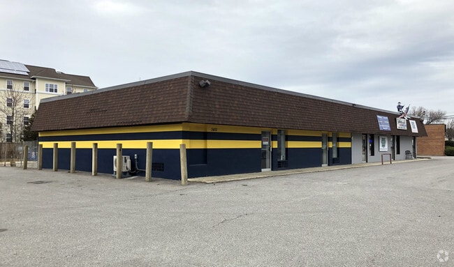
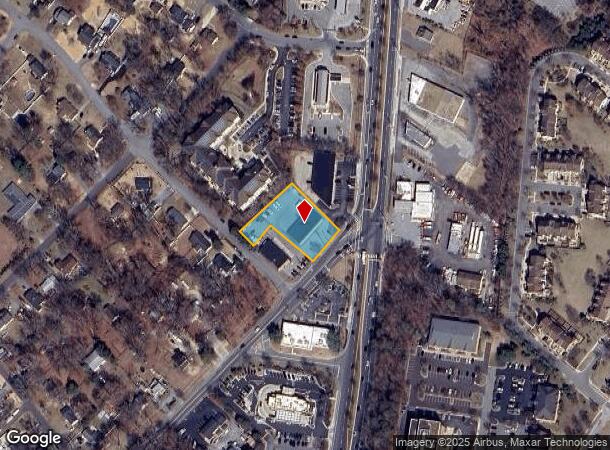
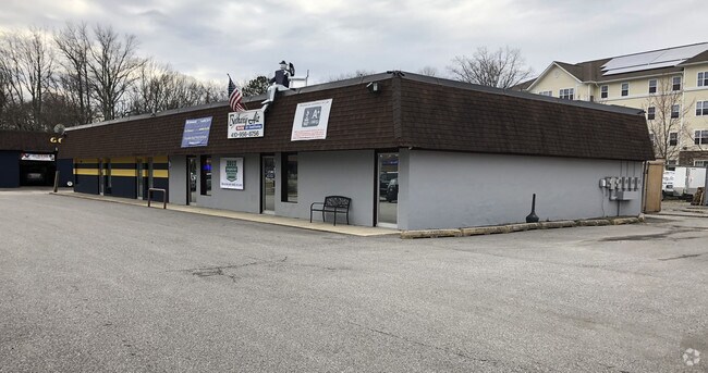
3410 Pike Ridge Rd, Edgewater, MD 21037
NEARBY LISTINGS FOR SALE OR LEASE
Property Detail
3410 Pike Ridge Rd
01-000-04489406
Kramer Comm Complex
Storebuilding
.775 ACRE PARCEL 1 KRAMER COMM COMPLEX
X
Anne Arundel
24003C0237F
Maryland
2024
0.78 AC
2025
Southern Anne Arundel
701101
Baltimore
4,725 SF
Baltimore-Columbia-Towson, MD
DEMOGRAPHICS near 3410 Pike Ridge Rd
1 Mile
3 Mile
5 Mile
2024 Total Population
6,410
26,542
89,766
2029 Population
6,529
27,119
92,027
Pop Growth 2024-2029
+ 1.86%
+ 2.17%
+ 2.52%
Average Age
42
43
42
2024 Total Households
2,461
10,338
36,590
HH Growth 2024-2029
+ 1.91%
+ 2.28%
+ 2.62%
Median Household Inc
$111,391
$133,072
$113,458
Avg Household Size
2.50
2.50
2.40
2024 Avg HH Vehicles
2.00
2.00
2.00
Median Home Value
$407,511
$508,821
$504,220
Median Year Built
1980
1984
1981
Nearby Places
Map Layers
Map Styles
 Street
 Aerial
- Restaurants
- Banks
- Shops
- Fitness
- Groceries
PUBLIC TRANSPORTATION
AIRPORT
Baltimore/Washington International Thurgood Marshall
DRIVE
WALK
Distance
Baltimore/Washington International Thurgood Marshall
36 min
25.1 mi
Ronald Reagan Washington Ntl
DRIVE
WALK
Distance
Ronald Reagan Washington Ntl
49 min
31.1 mi
Freight Ports
Port of Baltimore
DRIVE
WALK
Distance
Port of Baltimore
43 min
30.6 mi
SALE & LEASE HISTORY
LISTING DATE
SALE/LEASE

Mar 23, 2018
For Lease
Nearby Properties
Address
Land Use
TOTAL SIZE
Lot Size
Zoning
Address
Land Use
TOTAL SIZE
Lot Size
Zoning
365,268 SF
4.85 AC
W1
Address
Land Use
TOTAL SIZE
Lot Size
Zoning
589,210 SF
111.38 AC
RA
Address
Land Use
TOTAL SIZE
Lot Size
Zoning
285,174 SF
24 AC
R2
Address
Land Use
TOTAL SIZE
Lot Size
Zoning
73.33 AC
R2
Address
Land Use
TOTAL SIZE
Lot Size
Zoning
91.22 AC
C2
Address
Land Use
TOTAL SIZE
Lot Size
Zoning
138,592 SF
8.47 AC
W1
Address
Land Use
TOTAL SIZE
Lot Size
Zoning
134,693 SF
6 AC
R2
Address
Land Use
TOTAL SIZE
Lot Size
Zoning
9.15 AC
C2
Address
Land Use
TOTAL SIZE
Lot Size
Zoning
117,008 SF
1.40 AC
C4
Address
Land Use
TOTAL SIZE
Lot Size
Zoning
149,300 SF
2.93 AC
C2
Address
Land Use
TOTAL SIZE
Lot Size
Zoning
132,000 SF
5.55 AC
W1B
Address
Land Use
TOTAL SIZE
Lot Size
Zoning
82,022 SF
50.50 AC
RA
Address
Land Use
TOTAL SIZE
Lot Size
Zoning
112,662 SF
14.44 AC
C3
Address
Land Use
TOTAL SIZE
Lot Size
Zoning
77,261 SF
3.56 AC
C3
Address
Land Use
TOTAL SIZE
Lot Size
Zoning
94,932 SF
9.52 AC
C4
Address
Land Use
TOTAL SIZE
Lot Size
Zoning
77,280 SF
7.52 AC
C2
Address
Land Use
TOTAL SIZE
Lot Size
Zoning
65,836 SF
10.73 AC
R2
Address
Land Use
TOTAL SIZE
Lot Size
Zoning
71,934 SF
8.34 AC
W1
Address
Land Use
TOTAL SIZE
Lot Size
Zoning
63,558 SF
0.43 AC
C2
Address
Land Use
TOTAL SIZE
Lot Size
Zoning
63,558 SF
0.43 AC
C2
Address
Land Use
TOTAL SIZE
Lot Size
Zoning
63,558 SF
0.43 AC
C2
Address
Land Use
TOTAL SIZE
Lot Size
Zoning
63,558 SF
0.43 AC
C2
Address
Land Use
TOTAL SIZE
Lot Size
Zoning
61,141 SF
5.05 AC
C3
Address
Land Use
TOTAL SIZE
Lot Size
Zoning
66,108 SF
3.78 AC
W1
Address
Land Use
TOTAL SIZE
Lot Size
Zoning
54,600 SF
8.18 AC
W1A
Address
Land Use
TOTAL SIZE
Lot Size
Zoning
72,031 SF
2.38 AC
C2
Address
Land Use
TOTAL SIZE
Lot Size
Zoning
41,817 SF
15.53 AC
R1
Address
Land Use
TOTAL SIZE
Lot Size
Zoning
95,316 SF
4.36 AC
W1B
Address
Land Use
TOTAL SIZE
Lot Size
Zoning
41,038 SF
3.84 AC
C2
Address
Land Use
TOTAL SIZE
Lot Size
Zoning
24,283 SF
7 AC
R2
The World's #1 Commercial Real Estate Marketplace
Connect with us
© 2025 CoStar Group
The information above has been obtained from sources believed reliable. While we do not doubt its accuracy we have not verified it and make no guarantee, warranty or representation about it. It is your responsibility to independently confirm its accuracy and completeness. Any projections, opinions, assumptions, or estimates used are for example only and do not represent the current or future performance of the property. The value of this transaction to you depends on tax and other factors which should be evaluated by your tax, financial, and legal advisors. You and your advisors should conduct a careful, independent investigation of the property to determine to your satisfaction the suitability of the property for your needs.