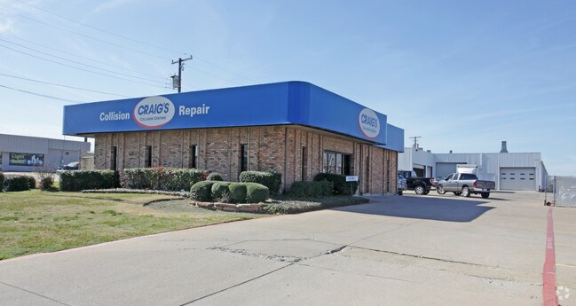
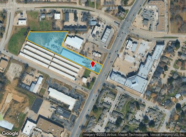
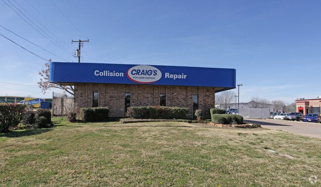
Property Record
3410 S Cooper St, Arlington, TX 76015
NEARBY LISTINGS FOR SALE OR LEASE
Property Detail
3410 S Cooper St
Dallas-Fort Worth-Arlington, TX
Schooler Tract Addition
04847830
SCHOOLER TRACT ADDITION LOT 3R
Commercialnec
Tarrant
X
Texas
48439C0335K
3r
2024
2.68 AC
2025
South Arlington
111553
Dallas/Ft Worth
19,670 SF
DEMOGRAPHICS near 3410 S Cooper St
1 Mile
3 Mile
5 Mile
2024 Total Population
12,825
126,345
337,353
2029 Population
13,393
132,868
354,874
Pop Growth 2024-2029
+ 4.43%
+ 5.16%
+ 5.19%
Average Age
37
37
37
2024 Total Households
5,019
45,727
118,450
HH Growth 2024-2029
+ 4.44%
+ 5.22%
+ 5.27%
Median Household Inc
$64,331
$62,576
$64,215
Avg Household Size
2.50
2.60
2.70
2024 Avg HH Vehicles
2.00
2.00
2.00
Median Home Value
$225,899
$238,734
$242,384
Median Year Built
1979
1980
1983
Nearby Places
Map Layers
Map Styles
 Street
 Aerial
- Restaurants
- Banks
- Shops
- Fitness
- Groceries
PUBLIC TRANSPORTATION
COMMUTER RAIL
Hurst/Bell (Trinity Railway Express - Dallas Area Rapid Transit (DART))
DRIVE
WALK
Distance
Hurst/Bell (Trinity Railway Express - Dallas Area Rapid Transit (DART))
24 min
9.7 mi
AIRPORT
Dallas-Fort Worth International
DRIVE
WALK
Distance
Dallas-Fort Worth International
31 min
19.9 mi
Dallas Love Field
DRIVE
WALK
Distance
Dallas Love Field
42 min
28.6 mi
Nearby Properties
Address
Land Use
TOTAL SIZE
Lot Size
Zoning
Address
Land Use
TOTAL SIZE
Lot Size
Zoning
1,342,617 SF
40.67 AC
Address
Land Use
TOTAL SIZE
Lot Size
Zoning
569,876 SF
47.80 AC
Address
Land Use
TOTAL SIZE
Lot Size
Zoning
320,636 SF
12.71 AC
Address
Land Use
TOTAL SIZE
Lot Size
Zoning
537,189 SF
29.08 AC
Address
Land Use
TOTAL SIZE
Lot Size
Zoning
799,893 SF
19.43 AC
Address
Land Use
TOTAL SIZE
Lot Size
Zoning
529,992 SF
35.21 AC
Address
Land Use
TOTAL SIZE
Lot Size
Zoning
462,207 SF
2.82 AC
Address
Land Use
TOTAL SIZE
Lot Size
Zoning
422,300 SF
2.50 AC
Address
Land Use
TOTAL SIZE
Lot Size
Zoning
347,421 SF
4.47 AC
Address
Land Use
TOTAL SIZE
Lot Size
Zoning
377,463 SF
19.50 AC
Address
Land Use
TOTAL SIZE
Lot Size
Zoning
569,312 SF
71.52 AC
Address
Land Use
TOTAL SIZE
Lot Size
Zoning
492,837 SF
4.99 AC
Address
Land Use
TOTAL SIZE
Lot Size
Zoning
462,396 SF
25.76 AC
Address
Land Use
TOTAL SIZE
Lot Size
Zoning
280,000 SF
10.85 AC
Address
Land Use
TOTAL SIZE
Lot Size
Zoning
296,092 SF
7.66 AC
Address
Land Use
TOTAL SIZE
Lot Size
Zoning
252,416 SF
15.86 AC
Address
Land Use
TOTAL SIZE
Lot Size
Zoning
162,537 SF
19.70 AC
Address
Land Use
TOTAL SIZE
Lot Size
Zoning
858,995 SF
41.93 AC
Address
Land Use
TOTAL SIZE
Lot Size
Zoning
202,262 SF
12.59 AC
Address
Land Use
TOTAL SIZE
Lot Size
Zoning
386,575 SF
42.27 AC
Address
Land Use
TOTAL SIZE
Lot Size
Zoning
28,825 SF
81.97 AC
Address
Land Use
TOTAL SIZE
Lot Size
Zoning
257,077 SF
14.49 AC
Address
Land Use
TOTAL SIZE
Lot Size
Zoning
260,031 SF
11.41 AC
Address
Land Use
TOTAL SIZE
Lot Size
Zoning
242,811 SF
13.60 AC
Address
Land Use
TOTAL SIZE
Lot Size
Zoning
268,340 SF
70 AC
Address
Land Use
TOTAL SIZE
Lot Size
Zoning
258,465 SF
8.99 AC
Address
Land Use
TOTAL SIZE
Lot Size
Zoning
425,000 SF
21.26 AC
Address
Land Use
TOTAL SIZE
Lot Size
Zoning
415,800 SF
20.97 AC
Address
Land Use
TOTAL SIZE
Lot Size
Zoning
230,960 SF
9.63 AC
Address
Land Use
TOTAL SIZE
Lot Size
Zoning
218,110 SF
8.85 AC
The World's #1 Commercial Real Estate Marketplace
Connect with us
© 2026 CoStar Group
The information above has been obtained from sources believed reliable. While we do not doubt its accuracy we have not verified it and make no guarantee, warranty or representation about it. It is your responsibility to independently confirm its accuracy and completeness. Any projections, opinions, assumptions, or estimates used are for example only and do not represent the current or future performance of the property. The value of this transaction to you depends on tax and other factors which should be evaluated by your tax, financial, and legal advisors. You and your advisors should conduct a careful, independent investigation of the property to determine to your satisfaction the suitability of the property for your needs.