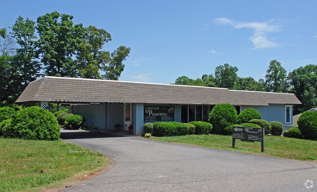
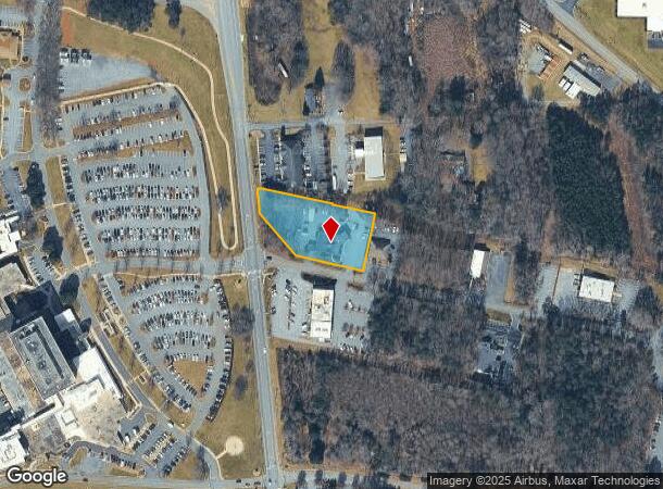
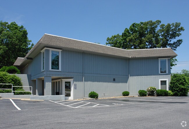
Property Record
3411 Graystone Pl Se, Conover, NC 28613
NEARBY LISTINGS FOR SALE OR LEASE
Property Detail
3411 Graystone Pl Se
Hickory-Lenoir-Morganton, NC
Medical Village
3722167287940000
LOT 2-3&PT1 MEDICAL V PL 55-168
Medicalbuilding
Catawba
X
North Carolina
3710372200J
2-3&1
0
1.16 AC
2025
Catawba County
010204
Charlotte
7,353 SF
DEMOGRAPHICS near 3411 Graystone Pl Se
1 Mile
3 Mile
5 Mile
2024 Total Population
1,470
18,939
68,089
2029 Population
1,545
19,752
71,238
Pop Growth 2024-2029
+ 5.10%
+ 4.29%
+ 4.62%
Average Age
36
39
40
2024 Total Households
493
7,523
27,756
HH Growth 2024-2029
+ 5.07%
+ 4.17%
+ 4.60%
Median Household Inc
$33,564
$52,694
$52,578
Avg Household Size
2.70
2.40
2.30
2024 Avg HH Vehicles
2.00
2.00
2.00
Median Home Value
$96,896
$161,396
$170,225
Median Year Built
1978
1985
1981
Nearby Places
Map Layers
Map Styles
 Street
 Aerial
- Restaurants
- Banks
- Shops
- Fitness
- Groceries
PUBLIC TRANSPORTATION
AIRPORT
Charlotte/Douglas International
DRIVE
WALK
Distance
Charlotte/Douglas International
74 min
47.2 mi
Nearby Properties
Address
Land Use
TOTAL SIZE
Lot Size
Zoning
Address
Land Use
TOTAL SIZE
Lot Size
Zoning
83,982 SF
96.78 AC
OI
Address
Land Use
TOTAL SIZE
Lot Size
Zoning
30,725 SF
17.17 AC
PD
Address
Land Use
TOTAL SIZE
Lot Size
Zoning
502,665 SF
53.28 AC
EM-1-CD
Address
Land Use
TOTAL SIZE
Lot Size
Zoning
57.59 AC
OI
Address
Land Use
TOTAL SIZE
Lot Size
Zoning
29,600 SF
19.05 AC
PD
Address
Land Use
TOTAL SIZE
Lot Size
Zoning
219,033 SF
32.95 AC
IND-CZ
Address
Land Use
TOTAL SIZE
Lot Size
Zoning
31,111 SF
8.79 AC
PD
Address
Land Use
TOTAL SIZE
Lot Size
Zoning
14,125 SF
16.76 AC
PD
Address
Land Use
TOTAL SIZE
Lot Size
Zoning
14,140 SF
15.26 AC
PD
Address
Land Use
TOTAL SIZE
Lot Size
Zoning
7,164 SF
45.82 AC
OI
Address
Land Use
TOTAL SIZE
Lot Size
Zoning
27,008 SF
12.02 AC
R-3
Address
Land Use
TOTAL SIZE
Lot Size
Zoning
94,152 SF
14.46 AC
IND
Address
Land Use
TOTAL SIZE
Lot Size
Zoning
19,444 SF
8.84 AC
PD
Address
Land Use
TOTAL SIZE
Lot Size
Zoning
57,658 SF
10.64 AC
OI
Address
Land Use
TOTAL SIZE
Lot Size
Zoning
326,813 SF
37.87 AC
IND
Address
Land Use
TOTAL SIZE
Lot Size
Zoning
31,854 SF
24.55 AC
PD
Address
Land Use
TOTAL SIZE
Lot Size
Zoning
353,092 SF
35.72 AC
IND
Address
Land Use
TOTAL SIZE
Lot Size
Zoning
7,684 SF
11.85 AC
R-20-CD
Address
Land Use
TOTAL SIZE
Lot Size
Zoning
300,990 SF
30.42 AC
IND-CZ
Address
Land Use
TOTAL SIZE
Lot Size
Zoning
125,920 SF
19.53 AC
C-3
Address
Land Use
TOTAL SIZE
Lot Size
Zoning
191,040 SF
25.30 AC
IND-CZ
Address
Land Use
TOTAL SIZE
Lot Size
Zoning
234,541 SF
9.07 AC
C-3
Address
Land Use
TOTAL SIZE
Lot Size
Zoning
123,778 SF
19.99 AC
C-3
Address
Land Use
TOTAL SIZE
Lot Size
Zoning
248,173 SF
53.73 AC
B-4
Address
Land Use
TOTAL SIZE
Lot Size
Zoning
201,590 SF
20.31 AC
C-3
Address
Land Use
TOTAL SIZE
Lot Size
Zoning
31,778 SF
2.53 AC
OI
Address
Land Use
TOTAL SIZE
Lot Size
Zoning
385,204 SF
14.33 AC
C-3
Address
Land Use
TOTAL SIZE
Lot Size
Zoning
60,130 SF
4.02 AC
IND
Address
Land Use
TOTAL SIZE
Lot Size
Zoning
30.63 AC
R-20
Address
Land Use
TOTAL SIZE
Lot Size
Zoning
39,752 SF
11.46 AC
PD
The World's #1 Commercial Real Estate Marketplace
Connect with us
© 2026 CoStar Group
The information above has been obtained from sources believed reliable. While we do not doubt its accuracy we have not verified it and make no guarantee, warranty or representation about it. It is your responsibility to independently confirm its accuracy and completeness. Any projections, opinions, assumptions, or estimates used are for example only and do not represent the current or future performance of the property. The value of this transaction to you depends on tax and other factors which should be evaluated by your tax, financial, and legal advisors. You and your advisors should conduct a careful, independent investigation of the property to determine to your satisfaction the suitability of the property for your needs.