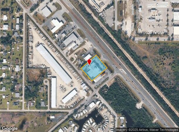
Property Record
3415 Tamiami Trl, Punta Gorda, FL 33950
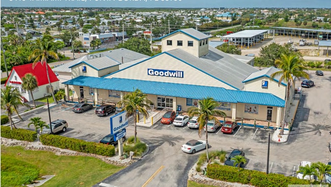
This Property Is For Sale
NEARBY LISTINGS FOR SALE OR LEASE
Property Detail
3415 Tamiami Trl
Punta Gorda, FL
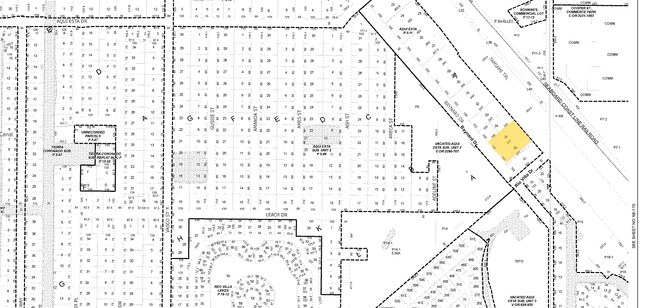
Aqui Esta
412318428009
AQUI ESTA BLK A LTS 35 & 36 LESS STATE RD ROW 101/407 313/279 500/396-97 C#75-408 PR85-314 POA1354/1186 DC1364/657 PR94-762 1485/1668 1732/407 1842/2154 4444/994 4511/741
Storemultistory
Charlotte
AE
Florida
12015C0241G
35,36
2024
1.10 AC
2025
Charlotte County
010301
Southwest Florida
18,074 SF
DEMOGRAPHICS near 3415 Tamiami Trl
1 Mile
3 Mile
5 Mile
2024 Total Population
4,514
28,554
43,323
2029 Population
5,375
34,431
52,172
Pop Growth 2024-2029
+ 19.07%
+ 20.58%
+ 20.43%
Average Age
60
59
58
2024 Total Households
2,353
14,228
21,355
HH Growth 2024-2029
+ 19.12%
+ 20.78%
+ 20.68%
Median Household Inc
$57,628
$64,691
$59,938
Avg Household Size
1.90
1.90
2.00
2024 Avg HH Vehicles
2.00
2.00
2.00
Median Home Value
$284,081
$402,408
$332,929
Median Year Built
1995
1994
1991
Nearby Places
- Restaurants
- Banks
- Shops
- Fitness
- Groceries
PUBLIC TRANSPORTATION
AIRPORT
Punta Gorda
DRIVE
WALK
Distance
Punta Gorda
8 min
3.9 mi
Southwest Florida International
DRIVE
WALK
Distance
Southwest Florida International
46 min
35.5 mi
Nearby Properties
Address
Land Use
TOTAL SIZE
Lot Size
Zoning
Address
Land Use
TOTAL SIZE
Lot Size
Zoning
349,844 SF
78.47 AC
P
Address
Land Use
TOTAL SIZE
Lot Size
Zoning
164,121 SF
44.20 AC
ECAP
Address
Land Use
TOTAL SIZE
Lot Size
Zoning
77,154 SF
10.30 AC
CC
Address
Land Use
TOTAL SIZE
Lot Size
Zoning
161,439 SF
171 AC
RE1
Address
Land Use
TOTAL SIZE
Lot Size
Zoning
265,949 SF
22.80 AC
PD-CC
Address
Land Use
TOTAL SIZE
Lot Size
Zoning
253,440 SF
30.47 AC
ECAP
Address
Land Use
TOTAL SIZE
Lot Size
Zoning
378,000 SF
29.24 AC
ECAP
Address
Land Use
TOTAL SIZE
Lot Size
Zoning
345,043 SF
33.12 AC
ECAP
Address
Land Use
TOTAL SIZE
Lot Size
Zoning
47,443 SF
7.94 AC
CC
Address
Land Use
TOTAL SIZE
Lot Size
Zoning
62,415 SF
281.65 AC
ECAP
Address
Land Use
TOTAL SIZE
Lot Size
Zoning
114,417 SF
4.36 AC
GM-15
Address
Land Use
TOTAL SIZE
Lot Size
Zoning
15,253 SF
13.27 AC
P
Address
Land Use
TOTAL SIZE
Lot Size
Zoning
198,916 SF
25.79 AC
HC
Address
Land Use
TOTAL SIZE
Lot Size
Zoning
208,560 SF
36.69 AC
PD-GM
Address
Land Use
TOTAL SIZE
Lot Size
Zoning
385,350 SF
374.81 AC
ECAP
Address
Land Use
TOTAL SIZE
Lot Size
Zoning
142,812 SF
7.89 AC
HC
Address
Land Use
TOTAL SIZE
Lot Size
Zoning
6,313 SF
15.49 AC
P
Address
Land Use
TOTAL SIZE
Lot Size
Zoning
73,095 SF
5 AC
NC
Address
Land Use
TOTAL SIZE
Lot Size
Zoning
44,185 SF
1.22 AC
CC
Address
Land Use
TOTAL SIZE
Lot Size
Zoning
25,356 SF
1.40 AC
CC
Address
Land Use
TOTAL SIZE
Lot Size
Zoning
96,845 SF
17.62 AC
HC
Address
Land Use
TOTAL SIZE
Lot Size
Zoning
8,406 SF
31.48 AC
ECAP
Address
Land Use
TOTAL SIZE
Lot Size
Zoning
82,379 SF
0.88 AC
CC
Address
Land Use
TOTAL SIZE
Lot Size
Zoning
12,159 SF
0.56 AC
CC
Address
Land Use
TOTAL SIZE
Lot Size
Zoning
24,880 SF
84.50 AC
PKR
Address
Land Use
TOTAL SIZE
Lot Size
Zoning
43,755 SF
8.19 AC
CC
Address
Land Use
TOTAL SIZE
Lot Size
Zoning
30,472 SF
3.19 AC
NR-10
Address
Land Use
TOTAL SIZE
Lot Size
Zoning
30,940 SF
0.42 AC
NC
Address
Land Use
TOTAL SIZE
Lot Size
Zoning
68,492 SF
6.38 AC
HC
Address
Land Use
TOTAL SIZE
Lot Size
Zoning
43,914 SF
4.06 AC
HC
The World's #1 Commercial Real Estate Marketplace
Connect with us
© 2025 CoStar Group
The information above has been obtained from sources believed reliable. While we do not doubt its accuracy we have not verified it and make no guarantee, warranty or representation about it. It is your responsibility to independently confirm its accuracy and completeness. Any projections, opinions, assumptions, or estimates used are for example only and do not represent the current or future performance of the property. The value of this transaction to you depends on tax and other factors which should be evaluated by your tax, financial, and legal advisors. You and your advisors should conduct a careful, independent investigation of the property to determine to your satisfaction the suitability of the property for your needs.