Property Record
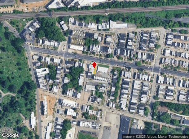
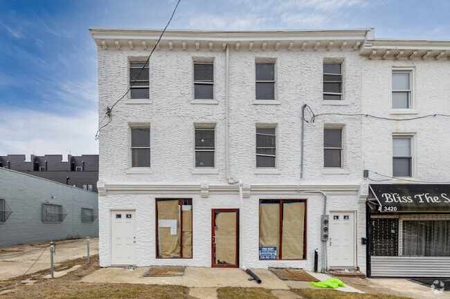
3416 W Allegheny Ave, Philadelphia, PA 19132

Current Lease Availabilities
NEARBY LISTINGS FOR SALE OR LEASE
Property Detail
3416 W Allegheny Ave
871553850
125W OF 34TH ST
Commercialnec
Philadelphia
X
Pennsylvania
42091C0395G
176
2024
0.02 AC
2026
Northwest Philadelphia
017000
Philadelphia
2,115 SF
Philadelphia-Camden-Wilmington, PA-NJ-DE-MD
DEMOGRAPHICS near 3416 W Allegheny Ave
1 Mile
3 Mile
5 Mile
2024 Total Population
28,317
356,106
1,025,876
2029 Population
28,034
351,323
1,003,341
Pop Growth 2024-2029
(1.00%)
(1.34%)
(2.20%)
Average Age
39
37
38
2024 Total Households
12,203
147,964
433,496
HH Growth 2024-2029
(1.43%)
(1.56%)
(2.43%)
Median Household Inc
$39,110
$41,200
$53,892
Avg Household Size
2.20
2.20
2.20
2024 Avg HH Vehicles
1.00
1.00
1.00
Median Home Value
$145,138
$207,260
$231,154
Median Year Built
1947
1948
1948
Nearby Places
- Restaurants
- Banks
- Shops
- Fitness
- Groceries
PUBLIC TRANSPORTATION
TRANSIT/SUBWAY
East Falls (R6 - Southeastern Pennsylvania Transportation Authority Regional Rail (SEPTA Regional Rail))
DRIVE
WALK
Distance
East Falls (R6 - Southeastern Pennsylvania Transportation Authority Regional Rail (SEPTA Regional Rail))
3 min
16 min
0.8 mi
COMMUTER RAIL
East Falls (R6 - Southeastern Pennsylvania Transportation Authority Regional Rail (SEPTA Regional Rail))
DRIVE
WALK
Distance
East Falls (R6 - Southeastern Pennsylvania Transportation Authority Regional Rail (SEPTA Regional Rail))
3 min
16 min
0.8 mi
Allegheny (R6 - Southeastern Pennsylvania Transportation Authority Regional Rail (SEPTA Regional Rail))
DRIVE
WALK
Distance
Allegheny (R6 - Southeastern Pennsylvania Transportation Authority Regional Rail (SEPTA Regional Rail))
3 min
1.1 mi
AIRPORT
Philadelphia International
DRIVE
WALK
Distance
Philadelphia International
29 min
14.5 mi
Trenton Mercer
DRIVE
WALK
Distance
Trenton Mercer
53 min
33.5 mi
Freight Ports
Port of Philadelphia
DRIVE
WALK
Distance
Port of Philadelphia
14 min
6.0 mi
Nearby Properties
Address
Land Use
TOTAL SIZE
Lot Size
Zoning
Address
Land Use
TOTAL SIZE
Lot Size
Zoning
26,690 SF
500 AC
SPINS
Address
Land Use
TOTAL SIZE
Lot Size
Zoning
500,165 SF
2.16 AC
SPPOA
Address
Land Use
TOTAL SIZE
Lot Size
Zoning
1.88 AC
SPINS
Address
Land Use
TOTAL SIZE
Lot Size
Zoning
391,885 SF
7.15 AC
RM4
Address
Land Use
TOTAL SIZE
Lot Size
Zoning
552,275 SF
1 AC
CMX3
Address
Land Use
TOTAL SIZE
Lot Size
Zoning
461,286 SF
2.64 AC
CMX4
Address
Land Use
TOTAL SIZE
Lot Size
Zoning
500,875 SF
4.31 AC
RM1
Address
Land Use
TOTAL SIZE
Lot Size
Zoning
455,889 SF
33 AC
I2
Address
Land Use
TOTAL SIZE
Lot Size
Zoning
285,615 SF
1.46 AC
SPINS
Address
Land Use
TOTAL SIZE
Lot Size
Zoning
520,280 SF
14.84 AC
RM3
Address
Land Use
TOTAL SIZE
Lot Size
Zoning
304,552 SF
1 AC
SPINS
Address
Land Use
TOTAL SIZE
Lot Size
Zoning
254,947 SF
1.73 AC
CMX4
Address
Land Use
TOTAL SIZE
Lot Size
Zoning
96,574 SF
2.42 AC
RM2
Address
Land Use
TOTAL SIZE
Lot Size
Zoning
22,648 SF
38.69 AC
RM3
Address
Land Use
TOTAL SIZE
Lot Size
Zoning
485,616 SF
8.96 AC
CMX3
Address
Land Use
TOTAL SIZE
Lot Size
Zoning
242,655 SF
3.29 AC
CMX3
Address
Land Use
TOTAL SIZE
Lot Size
Zoning
1,455,130 SF
6.80 AC
RSD3
Address
Land Use
TOTAL SIZE
Lot Size
Zoning
451,857 SF
3.57 AC
CMX2
Address
Land Use
TOTAL SIZE
Lot Size
Zoning
162,000 SF
8.16 AC
SPPOA
Address
Land Use
TOTAL SIZE
Lot Size
Zoning
425,535 SF
4.60 AC
RM3
Address
Land Use
TOTAL SIZE
Lot Size
Zoning
253,400 SF
10.90 AC
RM2
Address
Land Use
TOTAL SIZE
Lot Size
Zoning
3,590 SF
50 AC
SPPOA
Address
Land Use
TOTAL SIZE
Lot Size
Zoning
121,578 SF
3.13 AC
RSA3
Address
Land Use
TOTAL SIZE
Lot Size
Zoning
324,477 SF
1.99 AC
CMX4
Address
Land Use
TOTAL SIZE
Lot Size
Zoning
587,330 SF
34.37 AC
SPINS
Address
Land Use
TOTAL SIZE
Lot Size
Zoning
293,510 SF
7.03 AC
SPINS
Address
Land Use
TOTAL SIZE
Lot Size
Zoning
368,612 SF
20.06 AC
CMX2
Address
Land Use
TOTAL SIZE
Lot Size
Zoning
17,886 SF
80 AC
SPPOA
Address
Land Use
TOTAL SIZE
Lot Size
Zoning
164,412 SF
4.44 AC
SPINS
Address
Land Use
TOTAL SIZE
Lot Size
Zoning
418,017 SF
19.10 AC
CO
The World's #1 Commercial Real Estate Marketplace
Connect with us
© 2025 CoStar Group
The information above has been obtained from sources believed reliable. While we do not doubt its accuracy we have not verified it and make no guarantee, warranty or representation about it. It is your responsibility to independently confirm its accuracy and completeness. Any projections, opinions, assumptions, or estimates used are for example only and do not represent the current or future performance of the property. The value of this transaction to you depends on tax and other factors which should be evaluated by your tax, financial, and legal advisors. You and your advisors should conduct a careful, independent investigation of the property to determine to your satisfaction the suitability of the property for your needs.