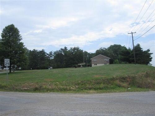
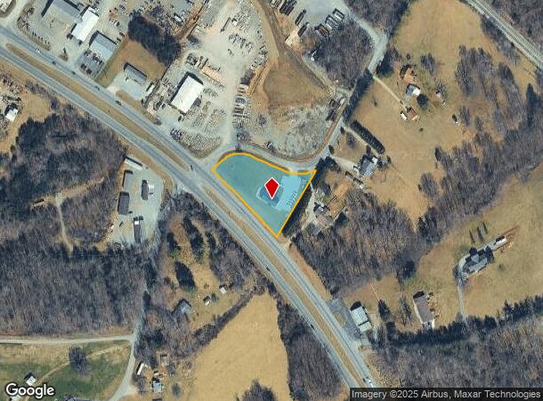
Property Record
3416 Iron Ridge Rd, Wirtz, VA 24184
NEARBY LISTINGS FOR SALE OR LEASE
-
-
View all Wirtz listings for sale on LoopNet.com
Property Detail
3416 Iron Ridge Rd
0440017400
N E SIDE 220 S SIDE 775
Officebuilding
Franklin
X
Virginia
51067C0185C
1.19 AC
2025
North Franklin County
2025
Roanoke
020400
Roanoke, VA
1,566 SF
DEMOGRAPHICS near 3416 Iron Ridge Rd
1 Mile
3 Mile
5 Mile
2024 Total Population
739
3,921
11,793
2029 Population
740
3,928
11,839
Pop Growth 2024-2029
+ 0.14%
+ 0.18%
+ 0.39%
Average Age
42
42
42
2024 Total Households
300
1,593
4,920
HH Growth 2024-2029
(0.33%)
0.00%
+ 0.18%
Median Household Inc
$60,170
$64,025
$55,683
Avg Household Size
2.50
2.40
2.30
2024 Avg HH Vehicles
2.00
2.00
2.00
Median Home Value
$190,093
$212,915
$191,085
Median Year Built
1985
1981
1979
Nearby Places
Map Layers
Map Styles
 Street
 Aerial
- Restaurants
- Banks
- Shops
- Fitness
- Groceries
PUBLIC TRANSPORTATION
AIRPORT
Roanoke/Blacksburg Regional (Woodrum Field)
DRIVE
WALK
Distance
Roanoke/Blacksburg Regional (Woodrum Field)
35 min
24.8 mi
Freight Ports
Virginia Port Authority - Richmond
DRIVE
WALK
Distance
Virginia Port Authority - Richmond
230 min
165.9 mi
SALE & LEASE HISTORY
LISTING DATE
SALE/LEASE

Mar 31, 2017
For Sale
Nearby Properties
Address
Land Use
TOTAL SIZE
Lot Size
Zoning
Address
Land Use
TOTAL SIZE
Lot Size
Zoning
50,216 SF
7.91 AC
B2
Address
Land Use
TOTAL SIZE
Lot Size
Zoning
115,920 SF
7.62 AC
SM
Address
Land Use
TOTAL SIZE
Lot Size
Zoning
39,172 SF
8.73 AC
A1
Address
Land Use
TOTAL SIZE
Lot Size
Zoning
21,012 SF
8.60 AC
REP
Address
Land Use
TOTAL SIZE
Lot Size
Zoning
6,760 SF
2.75 AC
SM
Address
Land Use
TOTAL SIZE
Lot Size
Zoning
5,000 SF
32.72 AC
SM
Address
Land Use
TOTAL SIZE
Lot Size
Zoning
14.54 AC
A1
Address
Land Use
TOTAL SIZE
Lot Size
Zoning
18,750 SF
2.41 AC
PCD
Address
Land Use
TOTAL SIZE
Lot Size
Zoning
56,000 SF
13.73 AC
B2
Address
Land Use
TOTAL SIZE
Lot Size
Zoning
30,100 SF
2.76 AC
SM
Address
Land Use
TOTAL SIZE
Lot Size
Zoning
51,280 SF
5.64 AC
B2
Address
Land Use
TOTAL SIZE
Lot Size
Zoning
6,621 SF
7.25 AC
SM
Address
Land Use
TOTAL SIZE
Lot Size
Zoning
16,112 SF
8 AC
B2
Address
Land Use
TOTAL SIZE
Lot Size
Zoning
28,990 SF
1.90 AC
B2
Address
Land Use
TOTAL SIZE
Lot Size
Zoning
50,400 SF
8.89 AC
REP
Address
Land Use
TOTAL SIZE
Lot Size
Zoning
16,200 SF
3.45 AC
Address
Land Use
TOTAL SIZE
Lot Size
Zoning
36,200 SF
2.30 AC
B2
Address
Land Use
TOTAL SIZE
Lot Size
Zoning
15,280 SF
16.48 AC
B2
Address
Land Use
TOTAL SIZE
Lot Size
Zoning
11,032 SF
1.80 AC
PCD
Address
Land Use
TOTAL SIZE
Lot Size
Zoning
9,220 SF
2.43 AC
B2
Address
Land Use
TOTAL SIZE
Lot Size
Zoning
13,422 SF
5.90 AC
A1
Address
Land Use
TOTAL SIZE
Lot Size
Zoning
3.39 AC
B2
Address
Land Use
TOTAL SIZE
Lot Size
Zoning
9,400 SF
11.88 AC
B2
Address
Land Use
TOTAL SIZE
Lot Size
Zoning
3,524 SF
3.94 AC
B2
Address
Land Use
TOTAL SIZE
Lot Size
Zoning
39.91 AC
SM
Address
Land Use
TOTAL SIZE
Lot Size
Zoning
7,800 SF
1.83 AC
A1
Address
Land Use
TOTAL SIZE
Lot Size
Zoning
21,416 SF
71.64 AC
M1
Address
Land Use
TOTAL SIZE
Lot Size
Zoning
30,000 SF
2.07 AC
M1
Address
Land Use
TOTAL SIZE
Lot Size
Zoning
Address
Land Use
TOTAL SIZE
Lot Size
Zoning
16,889 SF
3.37 AC
B2
The World's #1 Commercial Real Estate Marketplace
Connect with us
© 2025 CoStar Group
The information above has been obtained from sources believed reliable. While we do not doubt its accuracy we have not verified it and make no guarantee, warranty or representation about it. It is your responsibility to independently confirm its accuracy and completeness. Any projections, opinions, assumptions, or estimates used are for example only and do not represent the current or future performance of the property. The value of this transaction to you depends on tax and other factors which should be evaluated by your tax, financial, and legal advisors. You and your advisors should conduct a careful, independent investigation of the property to determine to your satisfaction the suitability of the property for your needs.