Property Record
Dye Rd, Swartz Creek, MI 48473
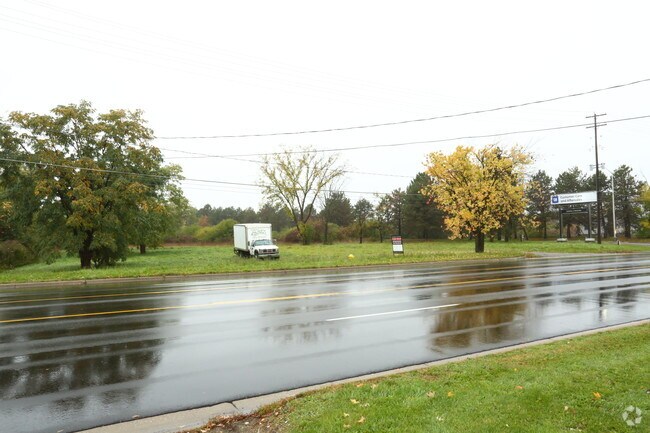
This Property Is For Sale
Property Detail
Dye Rd
Flint, MI
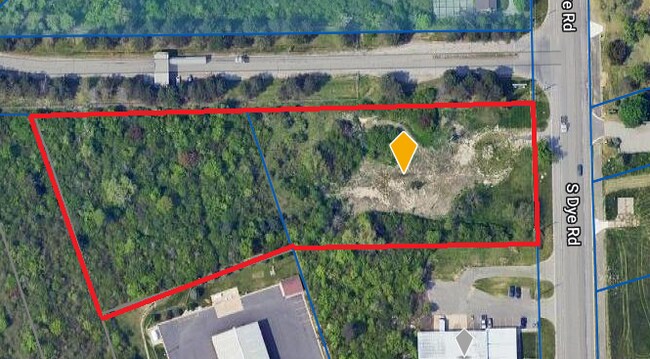
LOTS 15, 16 & 17 EXC SLY 655 FT & A 30 FT EASEMENT ALONG WLY 30 FT OF SLY 655 FT OF LOT 15 SUPERVISORS PLAT NO 44 (08) FR
58-29-551-030
GENESEE
Commercialacreage
Michigan
GBD
15-17
B and X Area of moderate flood hazard, usually the area between the limits of the 100-year and 500-year floods.
1.82 AC
2025
Flint
2025
Detroit
012802
NEARBY LISTINGS FOR SALE OR LEASE
DEMOGRAPHICS near Dye Rd
1 mile
3 mile
5 mile
2025 Total Population
1,385
20,584
76,840
2030 Population
1,378
20,271
76,163
Pop Growth 2025-2030
(0.51%)
(1.52%)
(0.88%)
Average Age
41
44
41
2025 Total Households
567
9,091
32,368
HH Growth 2025-2030
(0.53%)
(1.47%)
(0.88%)
Median Household Inc
$77,155
$63,720
$56,941
Avg Household Size
2.40
2.20
2.30
2025 Avg HH Vehicles
2.00
2.00
2.00
Median Home Value
$160,185
$165,780
$149,259
Median Year Built
1972
1971
1965
Nearby Places
Map Layers
Map Styles
 Street
 Aerial
Layers
 Traffic
 Biking
Places
Listings with unknown addresses are not visible on the map
- Restaurants
- Banks
- Shops
- Fitness
- Groceries
PUBLIC TRANSPORTATION
COMMUTER RAIL
Flint Amtrak Station (Blue Water - Amtrak)
Drive
Walk
Distance
Flint Amtrak Station (Blue Water - Amtrak)
12 min
8.2 mi
AIRPORT
Bishop International
Drive
Walk
Distance
Bishop International
14 min
3.6 mi
Freight Ports
Port of Toledo
Drive
Walk
Distance
Port of Toledo
134 min
112.6 mi
Nearby Properties
Address
Land Use
TOTAL SIZE
Lot Size
Zoning
Address
Land Use
TOTAL SIZE
Lot Size
Zoning
260,000 SF
15.55 AC
PC
Address
Land Use
TOTAL SIZE
Lot Size
Zoning
101,590 SF
5.54 AC
Address
Land Use
TOTAL SIZE
Lot Size
Zoning
51.34 AC
I-2
Address
Land Use
TOTAL SIZE
Lot Size
Zoning
179,638 SF
17.78 AC
RM-1
Address
Land Use
TOTAL SIZE
Lot Size
Zoning
190,917 SF
58.79 AC
GBD
Address
Land Use
TOTAL SIZE
Lot Size
Zoning
585,182 SF
78.28 AC
Address
Land Use
TOTAL SIZE
Lot Size
Zoning
401,680 SF
20.41 AC
PC
Address
Land Use
TOTAL SIZE
Lot Size
Zoning
112,232 SF
196 AC
Address
Land Use
TOTAL SIZE
Lot Size
Zoning
406,416 SF
21.10 AC
PC
Address
Land Use
TOTAL SIZE
Lot Size
Zoning
99,992 SF
8.39 AC
Address
Land Use
TOTAL SIZE
Lot Size
Zoning
460,000 SF
51.12 AC
PC
Address
Land Use
TOTAL SIZE
Lot Size
Zoning
85,936 SF
12.71 AC
Address
Land Use
TOTAL SIZE
Lot Size
Zoning
61,892 SF
10.61 AC
Address
Land Use
TOTAL SIZE
Lot Size
Zoning
153,343 SF
14.83 AC
Address
Land Use
TOTAL SIZE
Lot Size
Zoning
74.13 AC
I-2
Address
Land Use
TOTAL SIZE
Lot Size
Zoning
48,557 SF
2.99 AC
Address
Land Use
TOTAL SIZE
Lot Size
Zoning
27,100 SF
4.73 AC
Address
Land Use
TOTAL SIZE
Lot Size
Zoning
91,712 SF
9 AC
RM-1
Address
Land Use
TOTAL SIZE
Lot Size
Zoning
127,924 SF
22.33 AC
RM-1
Address
Land Use
TOTAL SIZE
Lot Size
Zoning
76,823 SF
114 AC
Address
Land Use
TOTAL SIZE
Lot Size
Zoning
23,500 SF
4.96 AC
Address
Land Use
TOTAL SIZE
Lot Size
Zoning
207,043 SF
24.20 AC
Address
Land Use
TOTAL SIZE
Lot Size
Zoning
214,422 SF
208 AC
Address
Land Use
TOTAL SIZE
Lot Size
Zoning
187,019 SF
180 AC
Address
Land Use
TOTAL SIZE
Lot Size
Zoning
235,611 SF
24 AC
Address
Land Use
TOTAL SIZE
Lot Size
Zoning
254,935 SF
3.33 AC
Address
Land Use
TOTAL SIZE
Lot Size
Zoning
6,051 SF
3.82 AC
Address
Land Use
TOTAL SIZE
Lot Size
Zoning
209,058 SF
9.02 AC
Address
Land Use
TOTAL SIZE
Lot Size
Zoning
64,065 SF
9.19 AC
GBD
Address
Land Use
TOTAL SIZE
Lot Size
Zoning
95,300 SF
9.26 AC
The World's #1 Commercial Real Estate Marketplace
Connect with us
© 2026 CoStar Group
The information above has been obtained from sources believed reliable. While we do not doubt its accuracy we have not verified it and make no guarantee, warranty or representation about it. It is your responsibility to independently confirm its accuracy and completeness. Any projections, opinions, assumptions, or estimates used are for example only and do not represent the current or future performance of the property. The value of this transaction to you depends on tax and other factors which should be evaluated by your tax, financial, and legal advisors. You and your advisors should conduct a careful, independent investigation of the property to determine to your satisfaction the suitability of the property for your needs.