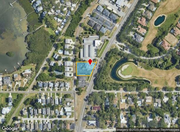
Property Record
3419 Alt 19, Palm Harbor, FL 34683
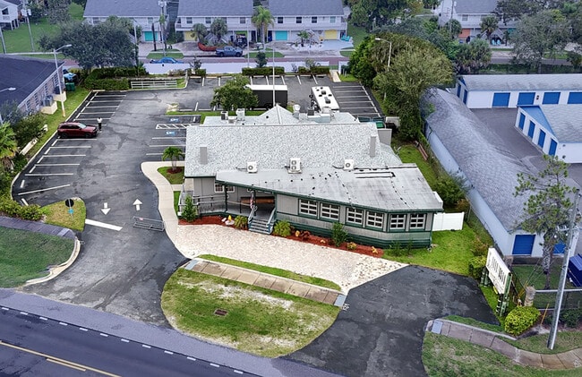
This Property Is For Sale
NEARBY LISTINGS FOR SALE OR LEASE
Property Detail
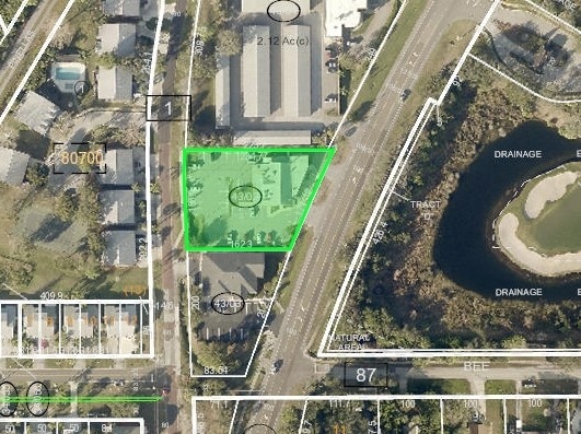
3419 Alt 19
26-27-15-00000-430-0200
Part Of Sw 1/4 Of Se 1/4
Restaurantbuilding
PART OF SW 1/4 OF SE 1/4 OF SEC 26-27-15 DESC FROM SW COR OF SE 1/4 OF SEC TH S89D5027E 30FT TH N01D0427W 200FT FOR POB TH N01D0427W 156.91FT TH S89D5027E 234.17FT TO WLY R/W OF US HWY 19A TH CUR LT RAD 2914.75FT ARC 171.42FT CB S23D5500W 171.41FT TH
AE
Pinellas
12103C0057H
Florida
2024
0.72 AC
2025
North Pinellas
027202
Tampa/St Petersburg
5,002 SF
Tampa-St. Petersburg-Clearwater, FL
DEMOGRAPHICS near 3419 Alt 19
1 Mile
3 Mile
5 Mile
2024 Total Population
4,180
47,099
115,976
2029 Population
3,957
46,721
115,572
Pop Growth 2024-2029
(5.33%)
(0.80%)
(0.35%)
Average Age
47
48
48
2024 Total Households
1,676
21,096
51,766
HH Growth 2024-2029
(6.03%)
(0.88%)
(0.47%)
Median Household Inc
$83,333
$66,216
$68,896
Avg Household Size
2.40
2.20
2.20
2024 Avg HH Vehicles
2.00
2.00
2.00
Median Home Value
$451,346
$323,366
$339,846
Median Year Built
1982
1983
1984
Nearby Places
Map Layers
Map Styles
 Street
 Aerial
- Restaurants
- Banks
- Shops
- Fitness
- Groceries
PUBLIC TRANSPORTATION
AIRPORT
Tampa International
DRIVE
WALK
Distance
Tampa International
37 min
21.4 mi
St Pete-Clearwater International
DRIVE
WALK
Distance
St Pete-Clearwater International
37 min
21.5 mi
Freight Ports
Port of Tampa Bay
DRIVE
WALK
Distance
Port of Tampa Bay
51 min
29.8 mi
Nearby Properties
Address
Land Use
TOTAL SIZE
Lot Size
Zoning
Address
Land Use
TOTAL SIZE
Lot Size
Zoning
535,063 SF
34.58 AC
RPD5
Address
Land Use
TOTAL SIZE
Lot Size
Zoning
341,775 SF
43.99 AC
Address
Land Use
TOTAL SIZE
Lot Size
Zoning
214,040 SF
8.47 AC
Address
Land Use
TOTAL SIZE
Lot Size
Zoning
270,606 SF
53.27 AC
AE
Address
Land Use
TOTAL SIZE
Lot Size
Zoning
286,598 SF
6.56 AC
Address
Land Use
TOTAL SIZE
Lot Size
Zoning
171,009 SF
49.16 AC
RPD10
Address
Land Use
TOTAL SIZE
Lot Size
Zoning
208,427 SF
12.11 AC
Address
Land Use
TOTAL SIZE
Lot Size
Zoning
188,845 SF
33.69 AC
RPD5
Address
Land Use
TOTAL SIZE
Lot Size
Zoning
144,838 SF
15.52 AC
CP1
Address
Land Use
TOTAL SIZE
Lot Size
Zoning
199,825 SF
22.75 AC
R2
Address
Land Use
TOTAL SIZE
Lot Size
Zoning
151,398 SF
15.55 AC
CP1
Address
Land Use
TOTAL SIZE
Lot Size
Zoning
311,414 SF
15.59 AC
RPD75
Address
Land Use
TOTAL SIZE
Lot Size
Zoning
116,975 SF
9 AC
AE
Address
Land Use
TOTAL SIZE
Lot Size
Zoning
137,649 SF
8.08 AC
Address
Land Use
TOTAL SIZE
Lot Size
Zoning
273,134 SF
1.44 AC
RPD5
Address
Land Use
TOTAL SIZE
Lot Size
Zoning
446,974 SF
11.32 AC
AE
Address
Land Use
TOTAL SIZE
Lot Size
Zoning
4,955 SF
135.03 AC
Address
Land Use
TOTAL SIZE
Lot Size
Zoning
92,817 SF
6.42 AC
PC
Address
Land Use
TOTAL SIZE
Lot Size
Zoning
112,719 SF
9.36 AC
CP1
Address
Land Use
TOTAL SIZE
Lot Size
Zoning
36,668 SF
65.18 AC
AE
Address
Land Use
TOTAL SIZE
Lot Size
Zoning
93,413 SF
12.35 AC
RPD10
Address
Land Use
TOTAL SIZE
Lot Size
Zoning
93,840 SF
8.66 AC
CP1
Address
Land Use
TOTAL SIZE
Lot Size
Zoning
81,053 SF
9.52 AC
Address
Land Use
TOTAL SIZE
Lot Size
Zoning
117,262 SF
15.32 AC
CP1
Address
Land Use
TOTAL SIZE
Lot Size
Zoning
65,929 SF
5.96 AC
C2
Address
Land Use
TOTAL SIZE
Lot Size
Zoning
103,393 SF
17.68 AC
R4
Address
Land Use
TOTAL SIZE
Lot Size
Zoning
67,179 SF
9.52 AC
Address
Land Use
TOTAL SIZE
Lot Size
Zoning
63,088 SF
7.50 AC
RPD10
Address
Land Use
TOTAL SIZE
Lot Size
Zoning
86,556 SF
7.44 AC
R6
Address
Land Use
TOTAL SIZE
Lot Size
Zoning
79,665 SF
7.26 AC
CP1
The World's #1 Commercial Real Estate Marketplace
Connect with us
© 2026 CoStar Group
The information above has been obtained from sources believed reliable. While we do not doubt its accuracy we have not verified it and make no guarantee, warranty or representation about it. It is your responsibility to independently confirm its accuracy and completeness. Any projections, opinions, assumptions, or estimates used are for example only and do not represent the current or future performance of the property. The value of this transaction to you depends on tax and other factors which should be evaluated by your tax, financial, and legal advisors. You and your advisors should conduct a careful, independent investigation of the property to determine to your satisfaction the suitability of the property for your needs.