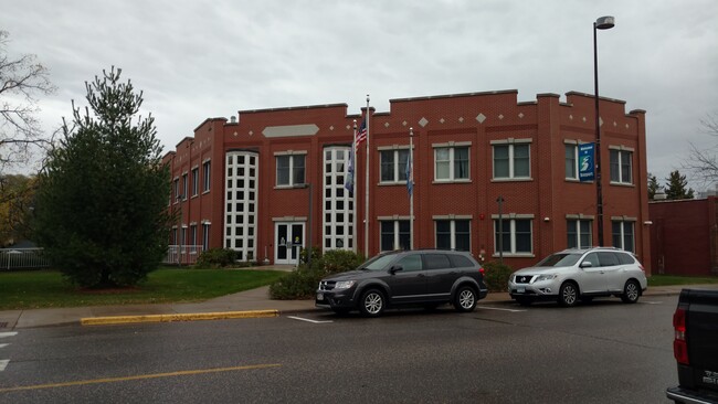
Property Record
342 5Th Ave N, Bayport, MN 55003

Current Lease Availabilities
NEARBY LISTINGS FOR SALE OR LEASE
Property Detail
342 5Th Ave N
Minneapolis-St. Paul-Bloomington, MN-WI
Bayport
03-029-20-44-0084
BLOCK 28 LOT 5 SUBDIVISIONCD 2670 SUBDIVISIONNAME BAYPORT (FORMERLY SO STILLWATER) BLOCK 28 LOT 8 SUBDIVISIONCD 2670 SUBDIVIS
Commercialnec
Washington
X
Minnesota
27163C0268E
5
2025
0.39 AC
2024
Washington Cnty Outlying
070704
Minneapolis/St Paul
13,112 SF
DEMOGRAPHICS near 342 5Th Ave N
1 Mile
3 Mile
5 Mile
2024 Total Population
2,827
22,220
55,196
2029 Population
3,078
24,009
59,793
Pop Growth 2024-2029
+ 8.88%
+ 8.05%
+ 8.33%
Average Age
41
44
43
2024 Total Households
1,185
9,520
22,261
HH Growth 2024-2029
+ 8.95%
+ 8.22%
+ 8.44%
Median Household Inc
$91,353
$101,009
$108,680
Avg Household Size
2.40
2.30
2.40
2024 Avg HH Vehicles
2.00
2.00
2.00
Median Home Value
$368,965
$374,958
$388,826
Median Year Built
1971
1979
1985
Nearby Places
Map Layers
Map Styles
 Street
 Aerial
- Restaurants
- Banks
- Shops
- Fitness
- Groceries
PUBLIC TRANSPORTATION
AIRPORT
Minneapolis-St Paul International/Wold-Chamberlain
DRIVE
WALK
Distance
Minneapolis-St Paul International/Wold-Chamberlain
41 min
29.7 mi
Freight Ports
Port Milwaukee
DRIVE
WALK
Distance
Port Milwaukee
349 min
317.4 mi
Nearby Properties
Address
Land Use
TOTAL SIZE
Lot Size
Zoning
Address
Land Use
TOTAL SIZE
Lot Size
Zoning
395,455 SF
Address
Land Use
TOTAL SIZE
Lot Size
Zoning
519,636 SF
40.40 AC
Address
Land Use
TOTAL SIZE
Lot Size
Zoning
600,000 SF
77.70 AC
Address
Land Use
TOTAL SIZE
Lot Size
Zoning
197,300 SF
0.55 AC
Address
Land Use
TOTAL SIZE
Lot Size
Zoning
198,596 SF
5 AC
Address
Land Use
TOTAL SIZE
Lot Size
Zoning
Address
Land Use
TOTAL SIZE
Lot Size
Zoning
84.75 AC
Address
Land Use
TOTAL SIZE
Lot Size
Zoning
81,240 SF
18.16 AC
Address
Land Use
TOTAL SIZE
Lot Size
Zoning
74,608 SF
0.66 AC
Address
Land Use
TOTAL SIZE
Lot Size
Zoning
Address
Land Use
TOTAL SIZE
Lot Size
Zoning
212,733 SF
23.97 AC
Address
Land Use
TOTAL SIZE
Lot Size
Zoning
132,967 SF
18.10 AC
Address
Land Use
TOTAL SIZE
Lot Size
Zoning
110,932 SF
1.59 AC
Address
Land Use
TOTAL SIZE
Lot Size
Zoning
66,665 SF
9.77 AC
Address
Land Use
TOTAL SIZE
Lot Size
Zoning
7,312 SF
3.43 AC
Address
Land Use
TOTAL SIZE
Lot Size
Zoning
46,145 SF
4.75 AC
Address
Land Use
TOTAL SIZE
Lot Size
Zoning
126,423 SF
2.84 AC
Address
Land Use
TOTAL SIZE
Lot Size
Zoning
84,546 SF
1.10 AC
Address
Land Use
TOTAL SIZE
Lot Size
Zoning
95,480 SF
1.11 AC
Address
Land Use
TOTAL SIZE
Lot Size
Zoning
71,848 SF
1.52 AC
Address
Land Use
TOTAL SIZE
Lot Size
Zoning
91,354 SF
5.51 AC
Address
Land Use
TOTAL SIZE
Lot Size
Zoning
125,897 SF
9.98 AC
Address
Land Use
TOTAL SIZE
Lot Size
Zoning
70,273 SF
8.49 AC
Address
Land Use
TOTAL SIZE
Lot Size
Zoning
91,378 SF
10.06 AC
Address
Land Use
TOTAL SIZE
Lot Size
Zoning
119,795 SF
1.48 AC
Address
Land Use
TOTAL SIZE
Lot Size
Zoning
243,612 SF
3.32 AC
Address
Land Use
TOTAL SIZE
Lot Size
Zoning
194,684 SF
14.86 AC
Address
Land Use
TOTAL SIZE
Lot Size
Zoning
268,209 SF
4.55 AC
Address
Land Use
TOTAL SIZE
Lot Size
Zoning
84,832 SF
1.61 AC
Address
Land Use
TOTAL SIZE
Lot Size
Zoning
47,664 SF
14.92 AC
The World's #1 Commercial Real Estate Marketplace
Connect with us
© 2025 CoStar Group
The information above has been obtained from sources believed reliable. While we do not doubt its accuracy we have not verified it and make no guarantee, warranty or representation about it. It is your responsibility to independently confirm its accuracy and completeness. Any projections, opinions, assumptions, or estimates used are for example only and do not represent the current or future performance of the property. The value of this transaction to you depends on tax and other factors which should be evaluated by your tax, financial, and legal advisors. You and your advisors should conduct a careful, independent investigation of the property to determine to your satisfaction the suitability of the property for your needs.